You are here: Home > Network List > TA - USArray Transportable Network (new EarthScope stations) Stations List
> Station TASL Snake Pit, Albuquerque Seismic Lab, NM, USA > Earthquake Result Viewer
TASL Snake Pit, Albuquerque Seismic Lab, NM, USA - Earthquake Result Viewer

| Earthquake location: |
Near Coast Of Peru |
| Earthquake latitude/longitude: |
-14.4/-75.6 |
| Earthquake time(UTC): |
2012/07/02 (184) 23:31:37 GMT |
| Earthquake Depth: |
40 km |
| Earthquake Magnitude: |
6.0 MB, 5.2 MS, 5.7 MW, 5.6 MW |
| Earthquake Catalog/Contributor: |
WHDF/NEIC |
|
| Network: |
TA USArray Transportable Network (new EarthScope stations) |
| Station: |
TASL Snake Pit, Albuquerque Seismic Lab, NM, USA |
| Lat/Lon: |
34.95 N/106.46 W |
| Elevation: |
1838 m |
|
| Distance: |
57.2 deg |
| Az: |
329.904 deg |
| Baz: |
143.743 deg |
| Ray Param: |
0.06358203 |
| Estimated Moho Depth: |
10.0 km |
| Estimated Crust Vp/Vs: |
1.91 |
| Assumed Crust Vp: |
6.502 km/s |
| Estimated Crust Vs: |
3.395 km/s |
| Estimated Crust Poisson's Ratio: |
0.31 |
|
| Radial Match: |
93.00774 % |
| Radial Bump: |
400 |
| Transverse Match: |
73.856606 % |
| Transverse Bump: |
400 |
| SOD ConfigId: |
463687 |
| Insert Time: |
2013-02-20 18:33:58.606 +0000 |
| GWidth: |
2.5 |
| Max Bumps: |
400 |
| Tol: |
0.001 |
|
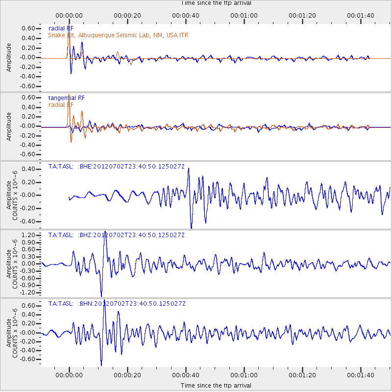
Signal To Noise
| Channel | StoN | STA | LTA |
| TA:TASL: :BHZ:20120702T23:40:50.125027Z | 5.112384 | 2.4460607E-7 | 4.78458E-8 |
| TA:TASL: :BHN:20120702T23:40:50.125027Z | 3.2655115 | 1.3174652E-7 | 4.0344833E-8 |
| TA:TASL: :BHE:20120702T23:40:50.125027Z | 2.1427426 | 9.180294E-8 | 4.2843663E-8 |
| Arrivals |
| Ps | 1.5 SECOND |
| PpPs | 4.3 SECOND |
| PsPs/PpSs | 5.8 SECOND |


