You are here: Home > Network List > AK - Alaska Regional Network Stations List
> Station GLM Gilmore Dome, AK, USA > Earthquake Result Viewer
GLM Gilmore Dome, AK, USA - Earthquake Result Viewer
| Earthquake location: |
Kuril Islands |
| Earthquake latitude/longitude: |
45.5/151.3 |
| Earthquake time(UTC): |
2012/07/08 (190) 11:33:02 GMT |
| Earthquake Depth: |
20 km |
| Earthquake Magnitude: |
5.7 MB, 5.6 MS, 6.0 MW, 5.8 MW |
| Earthquake Catalog/Contributor: |
WHDF/NEIC |
|
| Network: |
AK Alaska Regional Network |
| Station: |
GLM Gilmore Dome, AK, USA |
| Lat/Lon: |
64.99 N/147.40 W |
| Elevation: |
701 m |
|
| Distance: |
38.1 deg |
| Az: |
37.19 deg |
| Baz: |
269.686 deg |
| Ray Param: |
0.07573263 |
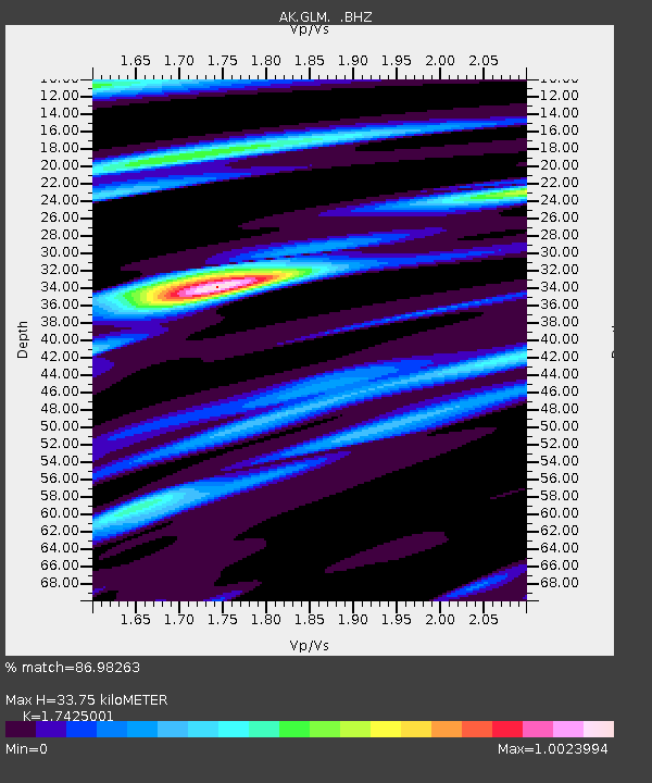
| Estimated Moho Depth: |
33.75 km |
| Estimated Crust Vp/Vs: |
1.74 |
| Assumed Crust Vp: |
6.566 km/s |
| Estimated Crust Vs: |
3.768 km/s |
| Estimated Crust Poisson's Ratio: |
0.25 |
|
| Radial Match: |
86.98263 % |
| Radial Bump: |
327 |
| Transverse Match: |
66.65125 % |
| Transverse Bump: |
400 |
| SOD ConfigId: |
463687 |
| Insert Time: |
2013-02-20 19:45:08.515 +0000 |
| GWidth: |
2.5 |
| Max Bumps: |
400 |
| Tol: |
0.001 |
|

Signal To Noise
| Channel | StoN | STA | LTA |
| AK:GLM: :BHZ:20120708T11:39:49.587999Z | 9.97754 | 9.019503E-7 | 9.039806E-8 |
| AK:GLM: :BHN:20120708T11:39:49.587999Z | 1.4263529 | 1.415935E-7 | 9.926963E-8 |
| AK:GLM: :BHE:20120708T11:39:49.587999Z | 4.216694 | 4.808139E-7 | 1.1402628E-7 |
| Arrivals |
| Ps | 4.1 SECOND |
| PpPs | 13 SECOND |
| PsPs/PpSs | 17 SECOND |


