You are here: Home > Network List > GS - US Geological Survey Networks Stations List
> Station CVRD ???? Centerville Rd, Mineral, VA 23117 USA > Earthquake Result Viewer
CVRD ???? Centerville Rd, Mineral, VA 23117 USA - Earthquake Result Viewer
| Earthquake location: |
Kuril Islands |
| Earthquake latitude/longitude: |
45.5/151.3 |
| Earthquake time(UTC): |
2012/07/08 (190) 11:33:02 GMT |
| Earthquake Depth: |
20 km |
| Earthquake Magnitude: |
5.7 MB, 5.6 MS, 6.0 MW, 5.8 MW |
| Earthquake Catalog/Contributor: |
WHDF/NEIC |
|
| Network: |
GS US Geological Survey Networks |
| Station: |
CVRD ???? Centerville Rd, Mineral, VA 23117 USA |
| Lat/Lon: |
38.07 N/77.81 W |
| Elevation: |
100 m |
|
| Distance: |
85.8 deg |
| Az: |
36.737 deg |
| Baz: |
327.791 deg |
| Ray Param: |
0.044477716 |
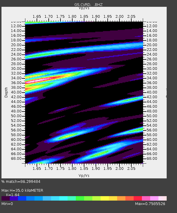
| Estimated Moho Depth: |
35.0 km |
| Estimated Crust Vp/Vs: |
1.64 |
| Assumed Crust Vp: |
6.419 km/s |
| Estimated Crust Vs: |
3.914 km/s |
| Estimated Crust Poisson's Ratio: |
0.20 |
|
| Radial Match: |
86.299484 % |
| Radial Bump: |
400 |
| Transverse Match: |
52.271805 % |
| Transverse Bump: |
400 |
| SOD ConfigId: |
463687 |
| Insert Time: |
2013-02-20 19:53:38.077 +0000 |
| GWidth: |
2.5 |
| Max Bumps: |
400 |
| Tol: |
0.001 |
|

Signal To Noise
| Channel | StoN | STA | LTA |
| GS:CVRD: :BHZ:20120708T11:45:09.414995Z | 6.2075706 | 4.5757923E-7 | 7.371309E-8 |
| GS:CVRD: :BHN:20120708T11:45:09.414995Z | 1.6883739 | 1.9397297E-7 | 1.1488745E-7 |
| GS:CVRD: :BHE:20120708T11:45:09.414995Z | 1.2460842 | 1.2516485E-7 | 1.0044655E-7 |
| Arrivals |
| Ps | 3.6 SECOND |
| PpPs | 14 SECOND |
| PsPs/PpSs | 18 SECOND |


