You are here: Home > Network List > TA - USArray Transportable Network (new EarthScope stations) Stations List
> Station TASL Snake Pit, Albuquerque Seismic Lab, NM, USA > Earthquake Result Viewer
TASL Snake Pit, Albuquerque Seismic Lab, NM, USA - Earthquake Result Viewer
| Earthquake location: |
Kuril Islands |
| Earthquake latitude/longitude: |
49.4/155.9 |
| Earthquake time(UTC): |
2012/07/20 (202) 06:10:25 GMT |
| Earthquake Depth: |
19 km |
| Earthquake Magnitude: |
5.7 MB, 5.7 MS, 6.0 MW, 6.1 MW |
| Earthquake Catalog/Contributor: |
WHDF/NEIC |
|
| Network: |
TA USArray Transportable Network (new EarthScope stations) |
| Station: |
TASL Snake Pit, Albuquerque Seismic Lab, NM, USA |
| Lat/Lon: |
34.95 N/106.46 W |
| Elevation: |
1838 m |
|
| Distance: |
68.9 deg |
| Az: |
60.796 deg |
| Baz: |
316.048 deg |
| Ray Param: |
0.056001414 |
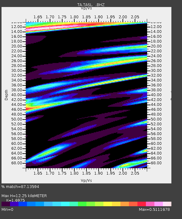
| Estimated Moho Depth: |
12.25 km |
| Estimated Crust Vp/Vs: |
1.70 |
| Assumed Crust Vp: |
6.502 km/s |
| Estimated Crust Vs: |
3.83 km/s |
| Estimated Crust Poisson's Ratio: |
0.23 |
|
| Radial Match: |
87.13594 % |
| Radial Bump: |
327 |
| Transverse Match: |
71.44339 % |
| Transverse Bump: |
400 |
| SOD ConfigId: |
469095 |
| Insert Time: |
2013-02-21 23:26:10.471 +0000 |
| GWidth: |
2.5 |
| Max Bumps: |
400 |
| Tol: |
0.001 |
|
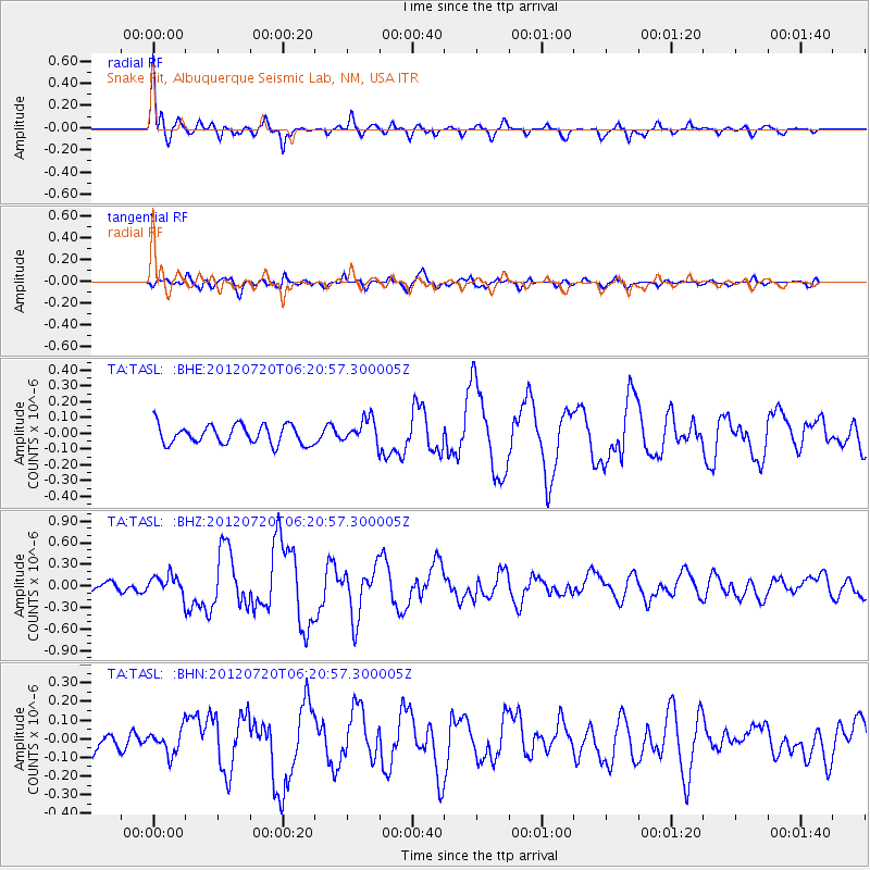
Signal To Noise
| Channel | StoN | STA | LTA |
| TA:TASL: :BHZ:20120720T06:20:57.300005Z | 3.2382922 | 1.3745904E-7 | 4.2448004E-8 |
| TA:TASL: :BHN:20120720T06:20:57.300005Z | 1.1099212 | 6.4710086E-8 | 5.8301513E-8 |
| TA:TASL: :BHE:20120720T06:20:57.300005Z | 1.313384 | 7.898312E-8 | 6.013711E-8 |
| Arrivals |
| Ps | 1.4 SECOND |
| PpPs | 4.9 SECOND |
| PsPs/PpSs | 6.2 SECOND |


