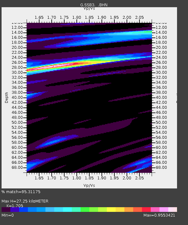
SSB3 Saint Sauveur Badole, France - Earthquake Result Viewer

Earthquake location: Andreanof Islands, Aleutian Is.
Earthquake latitude/longitude: 51.3/-178.7
Earthquake time(UTC): 1993/05/15 (135) 21:52:25 GMT
Earthquake Depth: 33 km
Earthquake Magnitude: 6.2 MB, 6.5 MS, 6.3 UNKNOWN, 6.1 ML
Earthquake Catalog/Contributor: WHDF/NEIC
Network: G GEOSCOPE
Station: SSB3 Saint Sauveur Badole, France
Lat/Lon: 45.28 N/4.54 E
Elevation: 700 m
Distance: 83.7 deg
Az: 357.726 deg
Baz: 2.02 deg
Ray Param: 0.04594221
Estimated Moho Depth: 27.25 km
Estimated Crust Vp/Vs: 1.71
Assumed Crust Vp: 6.1 km/s
Estimated Crust Vs: 3.578 km/s
Estimated Crust Poisson's Ratio: 0.24
Radial Match: 95.31175 %
Radial Bump: 352
Transverse Match: 74.32989 %
Transverse Bump: 400
SOD ConfigId: 16938
Insert Time: 2010-02-27 00:23:03.522 +0000
GWidth: 2.5
Max Bumps: 400
Tol: 0.001

Signal To Noise

ChannelStoNSTALTA
G:SSB3: :BHN:19930515T22:04:19.800024Z3.42362933.3995687E-79.9297225E-8
G:SSB3: :BHE:19930515T22:04:19.800024Z0.89640931.3677383E-71.5257967E-7
G:SSB3: :BHZ:19930515T22:04:19.800024Z4.35266161.000572E-62.298759E-7
Arrivals
Ps3.2 SECOND
PpPs12 SECOND
PsPs/PpSs15 SECOND