
Station G SSB3 - Saint Sauveur Badole, France
Network: G - GEOSCOPE
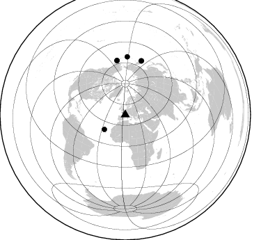
Nearby stations (2 deg radius)
| Station | Name | (Lat, Lon) | Start / End | Elevation |
| SSB3 | Saint Sauveur Badole, France | (45.28, 4.54) | 1993-05-04 / 1993-06-16 | 700 m |
| Crust2 Type: | M1,extended crust, 3 km seds. |
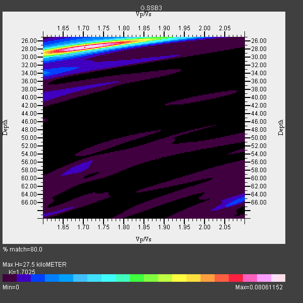
| Thickness Estimate: | 28 km |
| Thickness StdDev: | 0.2 km |
| Vp/Vs Estimate: | 1.70 |
| Vp/Vs StdDev: | 0.02 |
| Vs Estimate: | 3.583 km/s |
| Poisson's Ratio: | 0.24 |
| Peak Value: | 0.08 |
| Assumed Vp: | 6.1 km/s |
| Ps Weight: | 0.33333334 |
| PpPs Weight: | 0.33333334 |
| PsPs Weight: | 0.33333328 |
| Residual Complexity: | 0.209 |
| Nearby stations H: | 28 km +- 0.0 km |
| (2.0 deg) Vp/Vs: | 1.68 +- 0.03 |
4 with match > 90% ( 44.444443 %) and 6 with match > 80% ( 66.666664 %) out of 9.
Download stack as xyz text file.
Azimuth Distribution of Events:
Prior Results for this Station
| Study | Thickness | Vp/Vs | Vp | Vs | Poissons Ratio | Extra |
| EARS | 28 km | 1.70 | 6.1 km/s | 3.583 km/s | 0.24 | |
| Crust2.0 | 31 km | 1.78 | 6.1 km/s | 3.426 km/s | 0.27 | M1,extended crust, 3 km seds. |
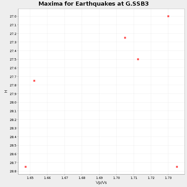
| Global Maxima | 28 km | 1.70 | 6.1 km/s | 3.583 km/s | 0.24 | amp=0.08061152 |
| Local Maxima 1 | 25 km | 1.91 | 6.1 km/s | 3.198 km/s | 0.31 | amp=0.017125225 |
| Local Maxima 2 | 34 km | 1.60 | 6.1 km/s | 3.812 km/s | 0.18 | amp=0.009928571 |
| Local Maxima 3 | 30 km | 1.60 | 6.1 km/s | 3.812 km/s | 0.18 | amp=0.00898766 |
| Local Maxima 4 | 38 km | 1.65 | 6.1 km/s | 3.697 km/s | 0.21 | amp=0.0066275 |
| Predicted Arrivals for vertical incidence (zero ray parameter) | |
| Ps | 3.17 SECOND |
| PpPs | 12.18 SECOND |
| PsPs/PpSs | 15.35 SECOND |
Events Processed for this Station
Download zip of receiver functions as SAC
Plot maxima for each earthquake.
Events Used in the Stack
(6 events)| Radial Match | Distance | Baz | FERegion | Time | Lat/Lon | Depth | Magnitude |
| 97.63881 | 81.1 deg | 16.621 deg | Near East Coast Of Kamchatka | 1993/06/08 13:03:37 GMT | (51.2, 157.8) | 81 km | 6.4 MB, 7.3 MS |
| 97.484566 | 79.1 deg | 351.304 deg | Alaska Peninsula | 1993/05/13 11:59:49 GMT | (55.2, -160.5) | 32 km | 6.4 MB, 6.8 MS, 6.8 UNKNOWN |
| 95.31175 | 83.7 deg | 2.02 deg | Andreanof Islands, Aleutian Is. | 1993/05/15 21:52:25 GMT | (51.3, -178.7) | 33 km | 6.2 MB, 6.5 MS, 6.3 UNKNOWN, 6.1 ML |
| 91.30062 | 36.7 deg | 234.738 deg | North Atlantic Ocean | 1993/05/29 06:50:13 GMT | (19.1, -26.5) | 10 km | 5.9 MB, 6.2 MS, 6.2 UNKNOWN |
| 84.06233 | 79.3 deg | 351.289 deg | Alaska Peninsula | 1993/05/25 23:16:43 GMT | (55.0, -160.5) | 33 km | 6.2 MB, 5.8 MS, 6.3 ML |
| 82.4566 | 81.1 deg | 16.672 deg | Near East Coast Of Kamchatka | 1993/06/12 20:33:26 GMT | (51.2, 157.7) | 49 km | 6.0 MB, 5.9 MS, 5.5 UNKNOWN, 6.3 MW |
Losers
(3 events)| Radial Match | Distance | Baz | FERegion | Time | Lat/Lon | Depth | Magnitude | Reason |
| 75.343315 | 87.0 deg | 290.738 deg | Near Coast Of Guerrero, Mexico | 1993/05/15 03:12:33 GMT | (16.7, -98.4) | 28 km | 5.9 MB, 5.9 MS | |
| 67.53902 | 87.0 deg | 290.793 deg | Near Coast Of Guerrero, Mexico | 1993/05/15 03:09:40 GMT | (16.8, -98.4) | 27 km | 5.8 MB, 5.8 MS, 5.7 UNKNOWN | |
| 58.819572 | 86.3 deg | 254.159 deg | Western Brazil | 1993/05/06 13:03:19 GMT | (-8.5, -71.5) | 586 km | 5.8 MB, 5.8 UNKNOWN |
