You are here: Home > Network List > TA - USArray Transportable Network (new EarthScope stations) Stations List
> Station 059A Moore Haven, FL, USA > Earthquake Result Viewer
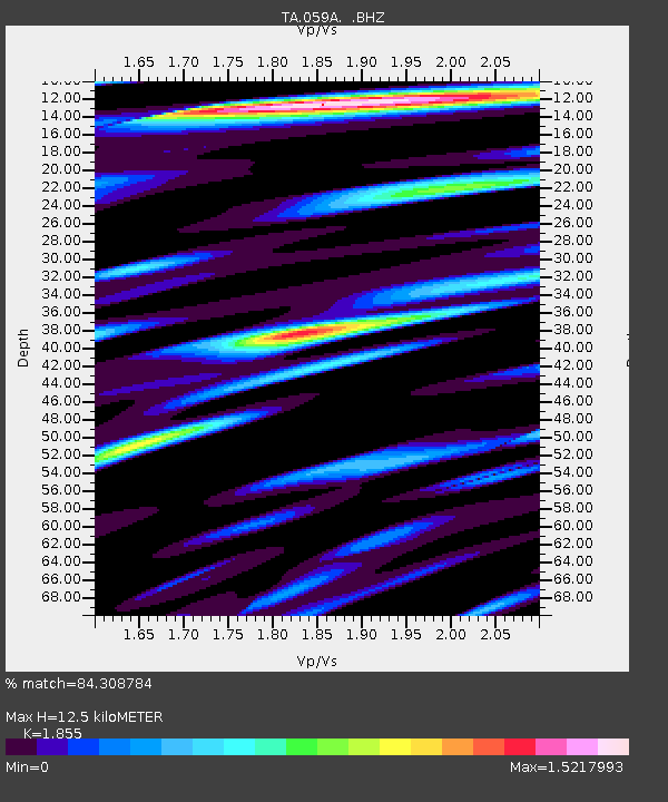
059A Moore Haven, FL, USA - Earthquake Result Viewer
| Earthquake location: |
Peru-Brazil Border Region |
| Earthquake latitude/longitude: |
-8.4/-74.3 |
| Earthquake time(UTC): |
2012/08/02 (215) 09:38:30 GMT |
| Earthquake Depth: |
145 km |
| Earthquake Magnitude: |
5.9 MB, 6.1 MW, 6.1 MW |
| Earthquake Catalog/Contributor: |
WHDF/NEIC |
|
| Network: |
TA USArray Transportable Network (new EarthScope stations) |
| Station: |
059A Moore Haven, FL, USA |
| Lat/Lon: |
26.97 N/81.14 W |
| Elevation: |
11 m |
|
| Distance: |
35.8 deg |
| Az: |
349.461 deg |
| Baz: |
168.302 deg |
| Ray Param: |
0.07652554 |
| Estimated Moho Depth: |
12.5 km |
| Estimated Crust Vp/Vs: |
1.86 |
| Assumed Crust Vp: |
6.347 km/s |
| Estimated Crust Vs: |
3.422 km/s |
| Estimated Crust Poisson's Ratio: |
0.30 |
|
| Radial Match: |
84.308784 % |
| Radial Bump: |
400 |
| Transverse Match: |
73.35876 % |
| Transverse Bump: |
400 |
| SOD ConfigId: |
469095 |
| Insert Time: |
2013-02-22 03:42:18.091 +0000 |
| GWidth: |
2.5 |
| Max Bumps: |
400 |
| Tol: |
0.001 |
|

Signal To Noise
| Channel | StoN | STA | LTA |
| TA:059A: :BHZ:20120802T09:44:45.850Z | 7.801372 | 1.9343954E-6 | 2.479558E-7 |
| TA:059A: :BHN:20120802T09:44:45.850Z | 2.8005404 | 1.0562089E-6 | 3.771447E-7 |
| TA:059A: :BHE:20120802T09:44:45.850Z | 1.4383264 | 5.31362E-7 | 3.6943075E-7 |
| Arrivals |
| Ps | 1.8 SECOND |
| PpPs | 5.2 SECOND |
| PsPs/PpSs | 7.1 SECOND |


