
Station TA 059A - Moore Haven, FL, USA
Network: TA - USArray Transportable Network (new EarthScope stations)
Nearby stations (2 deg radius)
| Station | Name | (Lat, Lon) | Start / End | Elevation |
| 059A | Moore Haven, FL, USA | (26.97, -81.14) | 2012-03-12 / 2599-12-31 | 11 m |
| Crust2 Type: | DH,thin Platform 4 km seds. |
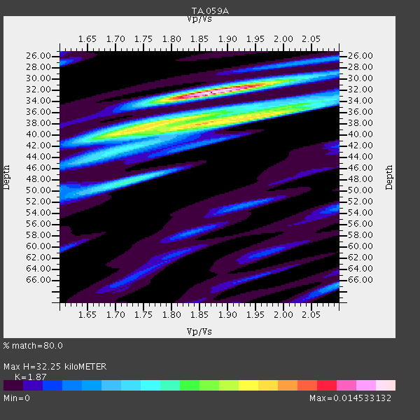
| Thickness Estimate: | 32 km |
| Thickness StdDev: | 4.2 km |
| Vp/Vs Estimate: | 1.87 |
| Vp/Vs StdDev: | 0.08 |
| Vs Estimate: | 3.394 km/s |
| Poisson's Ratio: | 0.30 |
| Peak Value: | 0.01 |
| Assumed Vp: | 6.347 km/s |
| Ps Weight: | 0.33333334 |
| PpPs Weight: | 0.33333334 |
| PsPs Weight: | 0.33333328 |
| Residual Complexity: | 0.746 |
| Nearby stations H: | +- |
| (2.0 deg) Vp/Vs: | +- |
5 with match > 90% ( 12.195122 %) and 11 with match > 80% ( 26.829268 %) out of 41.
Download stack as xyz text file.
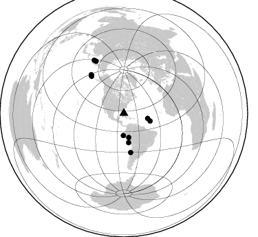
Azimuth Distribution of Events:
Prior Results for this Station
| Study | Thickness | Vp/Vs | Vp | Vs | Poissons Ratio | Extra |
| EARS | 32 km | 1.87 | 6.347 km/s | 3.394 km/s | 0.30 | |
| Crust2.0 | 34 km | 1.79 | 6.347 km/s | 3.553 km/s | 0.27 | DH,thin Platform 4 km seds. |
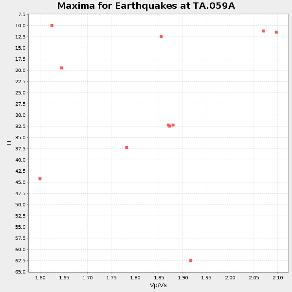
| Global Maxima | 32 km | 1.87 | 6.347 km/s | 3.394 km/s | 0.30 | amp=0.014533132 |
| Local Maxima 1 | 38 km | 1.86 | 6.347 km/s | 3.412 km/s | 0.30 | amp=0.010285502 |
| Local Maxima 2 | 48 km | 1.73 | 6.347 km/s | 3.674 km/s | 0.25 | amp=0.0063057607 |
| Local Maxima 3 | 37 km | 1.81 | 6.347 km/s | 3.502 km/s | 0.28 | amp=0.005556815 |
| Local Maxima 4 | 36 km | 1.99 | 6.347 km/s | 3.193 km/s | 0.33 | amp=0.0047935336 |
| Predicted Arrivals for vertical incidence (zero ray parameter) | |
| Ps | 4.42 SECOND |
| PpPs | 14.58 SECOND |
| PsPs/PpSs | 19.00 SECOND |
Events Processed for this Station
Download zip of receiver functions as SAC
Plot maxima for each earthquake.
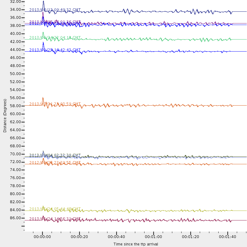
Events Used in the Stack
(11 events)| Radial Match | Distance | Baz | FERegion | Time | Lat/Lon | Depth | Magnitude |
| 95.34363 | 71.8 deg | 319.017 deg | Andreanof Islands, Aleutian Is. | 2013/08/30 16:25:02 GMT | (51.5, -175.2) | 29 km | 7.0 MWW, 6.5 ML, 6.8 MI, 6.9 MWC, 6.9 MWB, 7.0 MWW, 7.0 MI, 7.0 MWC |
| 94.074135 | 43.0 deg | 170.624 deg | Near Coast Of Peru | 2013/09/25 16:42:43 GMT | (-15.8, -74.5) | 40 km | 7.1 MWW, 6.8 MI, 7.0 MWB, 7.0 MWC, 7.1 MWW, 7.1 MWC |
| 93.16305 | 86.1 deg | 331.926 deg | Sea Of Okhotsk | 2013/05/24 05:44:48 GMT | (54.9, 153.2) | 598 km | 8.4 MW, 7.5 MB, 8.3 MW |
| 90.35735 | 73.5 deg | 319.805 deg | Andreanof Islands, Aleutian Is. | 2012/09/26 23:39:55 GMT | (51.6, -178.3) | 16 km | 6.3 MB, 6.5 MS, 6.4 MW, 6.4 MW |
| 90.05639 | 71.5 deg | 318.931 deg | Andreanof Islands, Aleutian Is. | 2013/09/04 02:32:30 GMT | (51.6, -174.8) | 20 km | 6.5 MWW, 5.9 ML, 6.3 MWB, 6.5 MI, 6.5 MWC, 6.5 MWW |
| 86.6311 | 35.4 deg | 102.006 deg | Northern Mid-Atlantic Ridge | 2013/09/05 04:01:36 GMT | (15.2, -45.2) | 10 km | 6.0 MWW, 5.9 MWB, 6.0 MWW, 6.0 MWC |
| 84.93819 | 32.2 deg | 181.463 deg | Near Coast Of Northern Peru | 2013/08/12 09:49:32 GMT | (-5.4, -81.9) | 10 km | 6.2 MWW, 6.1 MWB, 6.2 MWW, 6.2 MWC, 6.3 MWC |
| 84.38829 | 88.7 deg | 330.751 deg | Sea Of Okhotsk | 2013/05/24 14:56:31 GMT | (52.2, 151.4) | 624 km | 6.7 MW, 6.7 MB, 6.7 MW |
| 84.308784 | 35.8 deg | 168.302 deg | Peru-Brazil Border Region | 2012/08/02 09:38:30 GMT | (-8.4, -74.3) | 145 km | 5.9 MB, 6.1 MW, 6.1 MW |
| 84.18747 | 39.7 deg | 106.554 deg | Northern Mid-Atlantic Ridge | 2013/06/24 22:04:13 GMT | (10.7, -42.6) | 10 km | 6.5 MW, 6.1 MB, 6.3 MS, 6.6 MW |
| 83.88007 | 57.7 deg | 170.149 deg | Near Coast Of Central Chile | 2013/10/31 23:03:59 GMT | (-30.3, -71.5) | 27 km | 6.6 MWW, 6.4 MWB, 6.5 MWC, 6.6 MWW, 6.6 MI |
Losers
(30 events)| Radial Match | Distance | Baz | FERegion | Time | Lat/Lon | Depth | Magnitude | Reason |
| 79.722275 | 87.5 deg | 330.872 deg | Sea Of Okhotsk | 2013/10/01 03:38:21 GMT | (53.2, 152.8) | 573 km | 6.7 MWW, 6.7 MWC, 6.8 MWC, 6.8 MWB | |
| 78.87458 | 50.0 deg | 164.183 deg | Chile-Bolivia Border Region | 2012/10/08 01:50:26 GMT | (-21.7, -68.2) | 122 km | 6.0 MB, 5.7 MW, 5.8 MW | |
| 75.813675 | 30.3 deg | 289.859 deg | Southern California | 2012/08/26 20:57:58 GMT | (33.0, -115.5) | 9.0 km | 5.5 MW, 5.3 MS, 5.0 MB, 5.5 MW | |
| 75.650154 | 93.3 deg | 326.804 deg | Kuril Islands | 2013/04/19 03:05:52 GMT | (46.2, 150.8) | 110 km | 7.2 MW, 7.1 MB, 7.2 MW | |
| 73.78354 | 66.9 deg | 318.593 deg | Fox Islands, Aleutian Islands | 2012/08/10 18:37:43 GMT | (52.6, -167.4) | 13 km | 5.9 MB, 6.2 MS, 6.2 MW, 6.2 MW | |
| 73.22644 | 44.2 deg | 316.912 deg | Queen Charlotte Islands Region | 2013/09/03 20:19:06 GMT | (51.2, -130.4) | 2.7 km | 6.1 MWW, 6.0 MWB, 6.1 MWW, 6.1 MWC, 6.2 MI, 6.2 MWC | |
| 72.89833 | 86.9 deg | 327.292 deg | Kuril Islands | 2013/03/01 13:20:49 GMT | (51.0, 157.4) | 29 km | 6.3 MB, 6.3 MS, 6.5 MW, 6.4 MW | |
| 72.54171 | 44.1 deg | 316.865 deg | Queen Charlotte Islands Region | 2013/09/04 00:23:11 GMT | (51.2, -130.2) | 9.9 km | 6.0 MW, 5.9 MI, 5.9 MWR, 6.0 MWW, 6.0 MWW, 6.0 MWC | |
| 69.671646 | 41.4 deg | 166.896 deg | Central Peru | 2013/05/21 23:02:45 GMT | (-13.8, -72.3) | 92 km | 5.8 MW, 5.7 MB, 5.8 MW | |
| 67.59908 | 71.6 deg | 318.967 deg | Andreanof Islands, Aleutian Is. | 2013/09/04 06:27:03 GMT | (51.6, -174.9) | 17 km | 6.0 MWW, 5.5 ML, 5.9 MWB, 6.0 MWW, 6.1 MWC, 6.1 MI | |
| 66.504425 | 40.9 deg | 306.322 deg | Off Coast Of Oregon | 2012/04/11 22:41:46 GMT | (43.6, -127.6) | 8.0 km | 5.8 MB, 5.9 MS, 6.0 MW | |
| 66.47055 | 71.5 deg | 318.938 deg | Andreanof Islands, Aleutian Is. | 2013/09/15 16:21:37 GMT | (51.6, -174.7) | 24 km | 6.1 MWW, 5.7 MI, 5.7 ML, 6.0 MWB, 6.1 MWC, 6.1 MWW | |
| 66.07435 | 42.3 deg | 312.378 deg | Off Coast Of Washington | 2012/08/19 08:07:35 GMT | (47.8, -128.6) | 10 km | 5.6 MW, 5.3 MS, 5.2 MB, 5.5 MW | |
| 65.69901 | 71.5 deg | 318.952 deg | Andreanof Islands, Aleutian Is. | 2013/09/04 06:16:49 GMT | (51.6, -174.8) | 21 km | 5.7 MWW, 5.5 ML, 5.5 MI, 5.7 MWB, 5.7 MWW, 5.8 MWC | |
| 65.22645 | 84.7 deg | 327.315 deg | Off East Coast Of Kamchatka | 2013/05/19 18:44:10 GMT | (52.3, 160.1) | 18 km | 6.1 MW, 5.8 MS, 5.9 MB, 5.9 MW | |
| 65.13062 | 71.5 deg | 318.813 deg | Andreanof Islands, Aleutian Is. | 2013/09/04 04:16:30 GMT | (51.4, -174.7) | 27 km | 5.9 MW, 5.2 ML, 5.4 ML, 5.8 MWW, 5.8 MWW, 5.9 MWC | |
| 64.154076 | 31.7 deg | 170.395 deg | Northern Peru | 2012/11/28 03:09:48 GMT | (-4.5, -76.1) | 118 km | 5.9 MB, 5.6 MW, 5.7 MW | |
| 62.36709 | 43.3 deg | 166.742 deg | Southern Peru | 2013/07/17 02:37:43 GMT | (-15.7, -71.7) | 7.0 km | 6.0 MW, 5.6 MB, 5.8 MS, 5.8 MW | |
| 62.16431 | 71.4 deg | 318.796 deg | Andreanof Islands, Aleutian Is. | 2013/09/05 05:43:39 GMT | (51.5, -174.6) | 20 km | 5.6 MWW, 5.4 MI, 5.5 MWB, 5.6 MWW, 5.7 MWC, 5.7 ML, 5.8 MWC | |
| 61.158688 | 80.2 deg | 344.449 deg | Eastern Siberia, Russia | 2013/02/14 13:13:53 GMT | (67.6, 142.5) | 11 km | 6.5 MB, 6.7 MS, 6.6 MW, 6.7 MW | |
| 60.2704 | 78.3 deg | 324.22 deg | Near Islands, Aleutian Islands | 2012/06/19 15:56:32 GMT | (53.4, 171.6) | 14 km | 6.2 MB, 5.7 MS, 6.0 MW, 6.1 MW | |
| 60.181118 | 50.4 deg | 164.864 deg | Northern Chile | 2013/08/23 08:34:06 GMT | (-22.3, -68.6) | 111 km | 5.8 MWW, 5.7 MWD, 5.8 MWW, 5.8 MWB, 5.8 MWC | |
| 60.17759 | 71.7 deg | 318.655 deg | Andreanof Islands, Aleutian Is. | 2013/08/31 06:38:36 GMT | (51.2, -174.9) | 18 km | 6.0 MWW, 5.5 ML, 5.9 MWB, 5.9 MWC, 6.0 MWC, 6.0 MI, 6.0 MWW | |
| 57.335514 | 88.2 deg | 326.68 deg | Kuril Islands | 2012/10/16 12:41:25 GMT | (49.6, 156.4) | 81 km | 6.2 MB, 5.6 MW, 5.6 MW | |
| 55.116043 | 86.0 deg | 120.201 deg | South Atlantic Ocean | 2012/06/29 15:31:46 GMT | (-24.7, -9.7) | 10 km | 6.0 MB, 5.2 MS, 5.8 MW, 5.8 MW | |
| 54.372684 | 88.5 deg | 326.612 deg | Kuril Islands | 2012/07/20 06:32:56 GMT | (49.4, 156.1) | 10 km | 5.8 MB, 5.5 MS, 5.8 MW, 5.9 MW | |
| 53.93792 | 73.5 deg | 319.859 deg | Andreanof Islands, Aleutian Is. | 2013/04/21 13:48:29 GMT | (51.7, -178.2) | 44 km | 5.6 MW, 5.7 MW, 5.9 MB | |
| 51.508762 | 66.9 deg | 317.455 deg | Fox Islands, Aleutian Islands | 2013/07/03 03:40:27 GMT | (51.6, -167.0) | 5.1 km | 5.8 MW, 5.7 MW, 5.9 MB | |
| 48.484802 | 51.2 deg | 162.786 deg | Jujuy Province, Argentina | 2013/06/08 12:25:08 GMT | (-22.6, -66.7) | 215 km | 5.6 MW, 5.5 MB, 5.6 MW | |
| 34.542072 | 33.4 deg | 99.245 deg | Northern Mid-Atlantic Ridge | 2012/10/04 23:14:56 GMT | (17.4, -46.5) | 10 km | 5.5 MW, 5.0 MS, 5.4 MW, 5.3 MB |
