You are here: Home > Network List > TA - USArray Transportable Network (new EarthScope stations) Stations List
> Station TASL Snake Pit, Albuquerque Seismic Lab, NM, USA > Earthquake Result Viewer
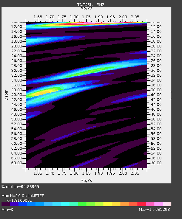
TASL Snake Pit, Albuquerque Seismic Lab, NM, USA - Earthquake Result Viewer
| Earthquake location: |
Peru-Brazil Border Region |
| Earthquake latitude/longitude: |
-8.4/-74.3 |
| Earthquake time(UTC): |
2012/08/02 (215) 09:38:30 GMT |
| Earthquake Depth: |
145 km |
| Earthquake Magnitude: |
5.9 MB, 6.1 MW, 6.1 MW |
| Earthquake Catalog/Contributor: |
WHDF/NEIC |
|
| Network: |
TA USArray Transportable Network (new EarthScope stations) |
| Station: |
TASL Snake Pit, Albuquerque Seismic Lab, NM, USA |
| Lat/Lon: |
34.95 N/106.46 W |
| Elevation: |
1838 m |
|
| Distance: |
52.8 deg |
| Az: |
326.654 deg |
| Baz: |
138.545 deg |
| Ray Param: |
0.06604378 |
| Estimated Moho Depth: |
10.0 km |
| Estimated Crust Vp/Vs: |
1.91 |
| Assumed Crust Vp: |
6.502 km/s |
| Estimated Crust Vs: |
3.404 km/s |
| Estimated Crust Poisson's Ratio: |
0.31 |
|
| Radial Match: |
94.88965 % |
| Radial Bump: |
348 |
| Transverse Match: |
77.41324 % |
| Transverse Bump: |
400 |
| SOD ConfigId: |
469095 |
| Insert Time: |
2013-02-22 03:44:57.605 +0000 |
| GWidth: |
2.5 |
| Max Bumps: |
400 |
| Tol: |
0.001 |
|

Signal To Noise
| Channel | StoN | STA | LTA |
| TA:TASL: :BHZ:20120802T09:47:00.475Z | 21.57955 | 1.3687292E-6 | 6.3427144E-8 |
| TA:TASL: :BHN:20120802T09:47:00.475Z | 13.988015 | 4.937363E-7 | 3.529709E-8 |
| TA:TASL: :BHE:20120802T09:47:00.475Z | 9.731927 | 3.9882786E-7 | 4.0981387E-8 |
| Arrivals |
| Ps | 1.5 SECOND |
| PpPs | 4.3 SECOND |
| PsPs/PpSs | 5.7 SECOND |


