You are here: Home > Network List > YE11 - Testing TA and FA Vaults and Directly Buried Sensors (3T) Stations List
> Station DBTTP Socorro, NM > Earthquake Result Viewer
DBTTP Socorro, NM - Earthquake Result Viewer
| Earthquake location: |
Peru-Brazil Border Region |
| Earthquake latitude/longitude: |
-8.4/-74.3 |
| Earthquake time(UTC): |
2012/08/02 (215) 09:38:30 GMT |
| Earthquake Depth: |
145 km |
| Earthquake Magnitude: |
5.9 MB, 6.1 MW, 6.1 MW |
| Earthquake Catalog/Contributor: |
WHDF/NEIC |
|
| Network: |
YE Testing TA and FA Vaults and Directly Buried Sensors (3T) |
| Station: |
DBTTP Socorro, NM |
| Lat/Lon: |
33.96 N/106.85 W |
| Elevation: |
1396 m |
|
| Distance: |
52.3 deg |
| Az: |
325.523 deg |
| Baz: |
137.637 deg |
| Ray Param: |
0.066387944 |
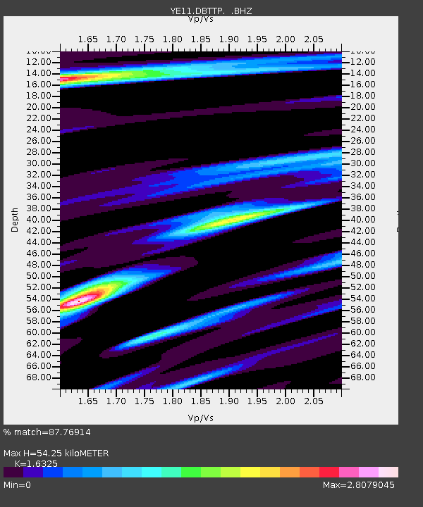
| Estimated Moho Depth: |
54.25 km |
| Estimated Crust Vp/Vs: |
1.63 |
| Assumed Crust Vp: |
6.502 km/s |
| Estimated Crust Vs: |
3.983 km/s |
| Estimated Crust Poisson's Ratio: |
0.20 |
|
| Radial Match: |
87.76914 % |
| Radial Bump: |
381 |
| Transverse Match: |
82.52148 % |
| Transverse Bump: |
400 |
| SOD ConfigId: |
469095 |
| Insert Time: |
2013-02-22 03:53:51.694 +0000 |
| GWidth: |
2.5 |
| Max Bumps: |
400 |
| Tol: |
0.001 |
|

Signal To Noise
| Channel | StoN | STA | LTA |
| YE:DBTTP: :BHZ:20120802T09:46:56.649988Z | 18.784254 | 1.7736614E-6 | 9.4422774E-8 |
| YE:DBTTP: :BHN:20120802T09:46:56.649988Z | 4.5585313 | 8.4349153E-7 | 1.850358E-7 |
| YE:DBTTP: :BHE:20120802T09:46:56.649988Z | 4.61978 | 7.9381016E-7 | 1.7182856E-7 |
| Arrivals |
| Ps | 5.6 SECOND |
| PpPs | 21 SECOND |
| PsPs/PpSs | 26 SECOND |


