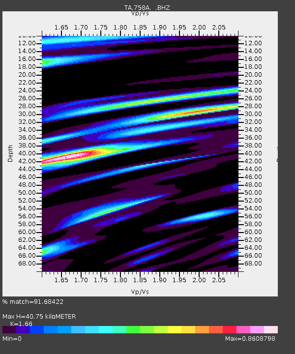
758A Lake Helen, FL, USA - Earthquake Result Viewer
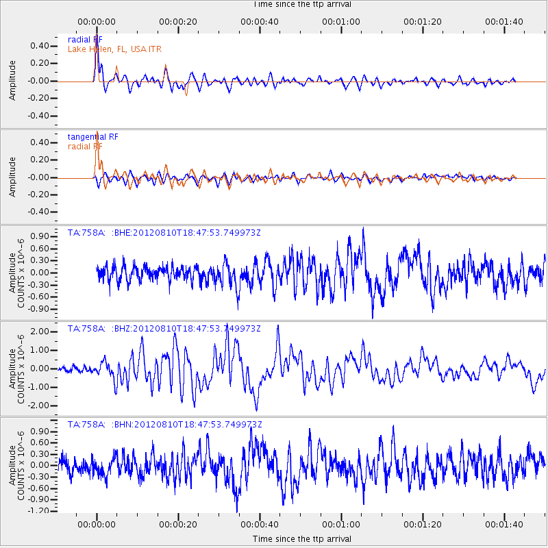
Earthquake location: Fox Islands, Aleutian Islands
Earthquake latitude/longitude: 52.6/-167.4
Earthquake time(UTC): 2012/08/10 (223) 18:37:43 GMT
Earthquake Depth: 13 km
Earthquake Magnitude: 5.9 MB, 6.2 MS, 6.2 MW, 6.2 MW
Earthquake Catalog/Contributor: WHDF/NEIC
Network: TA USArray Transportable Network (new EarthScope stations)
Station: 758A Lake Helen, FL, USA
Lat/Lon: 28.96 N/81.20 W
Elevation: 16 m
Distance: 65.3 deg
Az: 74.176 deg
Baz: 317.998 deg
Ray Param: 0.0583252
Estimated Moho Depth: 40.75 km
Estimated Crust Vp/Vs: 1.66
Assumed Crust Vp: 6.134 km/s
Estimated Crust Vs: 3.695 km/s
Estimated Crust Poisson's Ratio: 0.22
Radial Match: 91.68422 %
Radial Bump: 400
Transverse Match: 68.122765 %
Transverse Bump: 400
SOD ConfigId: 469095
Insert Time: 2013-02-22 06:11:28.279 +0000
GWidth: 2.5
Max Bumps: 400
Tol: 0.001

Signal To Noise

ChannelStoNSTALTA
TA:758A: :BHZ:20120810T18:47:53.749973Z3.4210034.881971E-71.4270584E-7
TA:758A: :BHN:20120810T18:47:53.749973Z1.13248592.2499613E-71.9867456E-7
TA:758A: :BHE:20120810T18:47:53.749973Z1.87163943.072965E-71.6418574E-7
Arrivals
Ps4.6 SECOND
PpPs17 SECOND
PsPs/PpSs22 SECOND