
Station TA 758A - Lake Helen, FL, USA
Network: TA - USArray Transportable Network (new EarthScope stations)
Nearby stations (2 deg radius)
| Station | Name | (Lat, Lon) | Start / End | Elevation |
| 758A | Lake Helen, FL, USA | (28.96, -81.20) | 2012-02-13 / 2599-12-31 | 16 m |
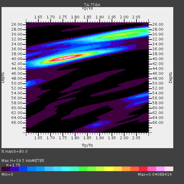
| Crust2 Type: | C3,continental shelf, 2 km seds. |
| Thickness Estimate: | 40 km |
| Thickness StdDev: | 1.6 km |
| Vp/Vs Estimate: | 1.75 |
| Vp/Vs StdDev: | 0.04 |
| Vs Estimate: | 3.505 km/s |
| Poisson's Ratio: | 0.26 |
| Peak Value: | 0.04 |
| Assumed Vp: | 6.134 km/s |
| Ps Weight: | 0.33333334 |
| PpPs Weight: | 0.33333334 |
| PsPs Weight: | 0.33333328 |
| Residual Complexity: | 0.586 |
| Nearby stations H: | +- |
| (2.0 deg) Vp/Vs: | +- |
8 with match > 90% ( 23.529411 %) and 11 with match > 80% ( 32.35294 %) out of 34.
Download stack as xyz text file.
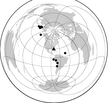
Azimuth Distribution of Events:
Prior Results for this Station
| Study | Thickness | Vp/Vs | Vp | Vs | Poissons Ratio | Extra |
| EARS | 40 km | 1.75 | 6.134 km/s | 3.505 km/s | 0.26 | |
| Crust2.0 | 31 km | 1.80 | 6.134 km/s | 3.406 km/s | 0.28 | C3,continental shelf, 2 km seds. |
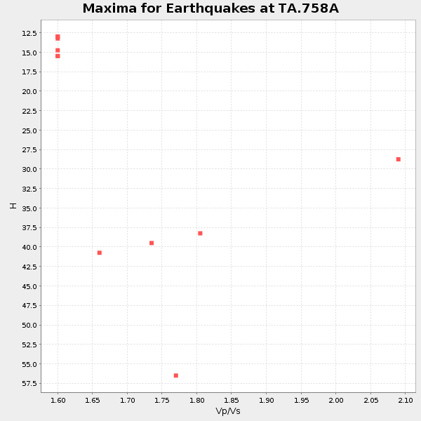
| Global Maxima | 40 km | 1.75 | 6.134 km/s | 3.505 km/s | 0.26 | amp=0.04088414 |
| Local Maxima 1 | 30 km | 1.97 | 6.134 km/s | 3.11 km/s | 0.33 | amp=0.022921605 |
| Local Maxima 2 | 28 km | 2.10 | 6.134 km/s | 2.924 km/s | 0.35 | amp=0.013584776 |
| Local Maxima 3 | 37 km | 1.88 | 6.134 km/s | 3.263 km/s | 0.30 | amp=0.008184017 |
| Local Maxima 4 | 54 km | 2.08 | 6.134 km/s | 2.945 km/s | 0.35 | amp=0.0074925935 |
| Predicted Arrivals for vertical incidence (zero ray parameter) | |
| Ps | 4.83 SECOND |
| PpPs | 17.71 SECOND |
| PsPs/PpSs | 22.54 SECOND |
Events Processed for this Station
Download zip of receiver functions as SAC
Plot maxima for each earthquake.
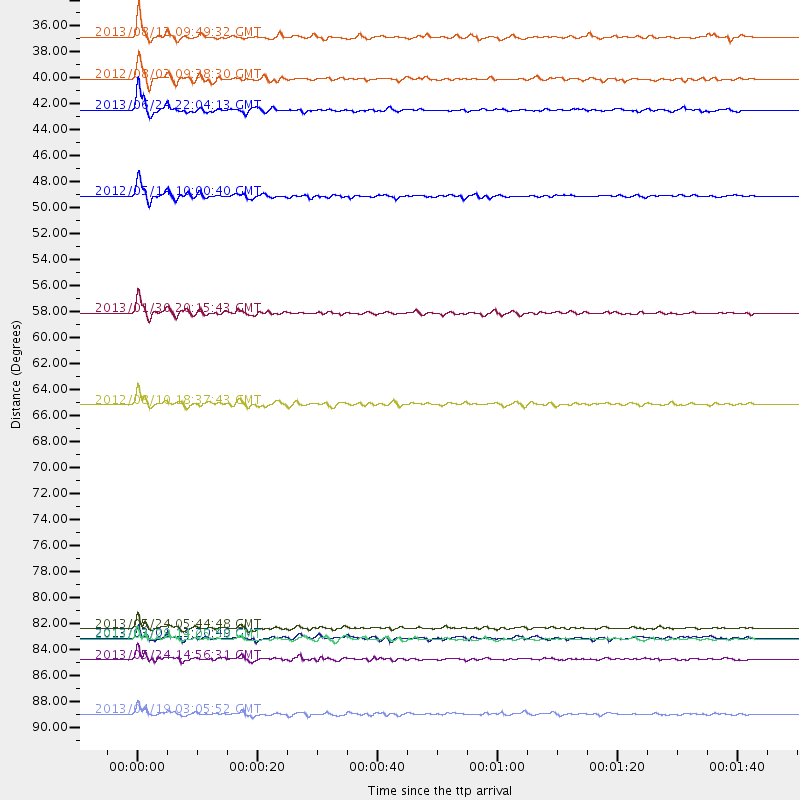
Events Used in the Stack
(11 events)| Radial Match | Distance | Baz | FERegion | Time | Lat/Lon | Depth | Magnitude |
| 95.211105 | 84.3 deg | 331.826 deg | Sea Of Okhotsk | 2013/05/24 05:44:48 GMT | (54.9, 153.2) | 598 km | 8.4 MW, 7.5 MB, 8.3 MW |
| 94.53777 | 47.7 deg | 164.968 deg | Peru-Bolivia Border Region | 2012/05/14 10:00:40 GMT | (-17.7, -69.6) | 106 km | 6.4 MB, 6.2 MW, 6.2 MW |
| 93.45092 | 91.6 deg | 326.822 deg | Kuril Islands | 2013/04/19 03:05:52 GMT | (46.2, 150.8) | 110 km | 7.2 MW, 7.1 MB, 7.2 MW |
| 92.90897 | 87.0 deg | 330.69 deg | Sea Of Okhotsk | 2013/05/24 14:56:31 GMT | (52.2, 151.4) | 624 km | 6.7 MW, 6.7 MB, 6.7 MW |
| 91.68422 | 65.3 deg | 317.998 deg | Fox Islands, Aleutian Islands | 2012/08/10 18:37:43 GMT | (52.6, -167.4) | 13 km | 5.9 MB, 6.2 MS, 6.2 MW, 6.2 MW |
| 91.486206 | 40.4 deg | 108.764 deg | Northern Mid-Atlantic Ridge | 2013/06/24 22:04:13 GMT | (10.7, -42.6) | 10 km | 6.5 MW, 6.1 MB, 6.3 MS, 6.6 MW |
| 91.3027 | 57.6 deg | 168.961 deg | Central Chile | 2013/01/30 20:15:43 GMT | (-28.1, -70.7) | 45 km | 6.5 MB, 6.5 MS, 6.8 MW, 6.8 MW |
| 90.627205 | 34.2 deg | 181.289 deg | Near Coast Of Northern Peru | 2013/08/12 09:49:32 GMT | (-5.4, -81.9) | 10 km | 6.2 MWW, 6.1 MWB, 6.2 MWW, 6.2 MWC, 6.3 MWC |
| 87.31077 | 37.8 deg | 168.74 deg | Peru-Brazil Border Region | 2012/08/02 09:38:30 GMT | (-8.4, -74.3) | 145 km | 5.9 MB, 6.1 MW, 6.1 MW |
| 85.47414 | 85.2 deg | 327.194 deg | Kuril Islands | 2013/03/01 13:20:49 GMT | (51.0, 157.4) | 29 km | 6.3 MB, 6.3 MS, 6.5 MW, 6.4 MW |
| 81.534805 | 85.2 deg | 327.243 deg | Kuril Islands | 2013/02/28 14:05:50 GMT | (51.0, 157.3) | 41 km | 6.4 MB, 6.7 MS, 6.9 MW, 6.8 MW |
Losers
(23 events)| Radial Match | Distance | Baz | FERegion | Time | Lat/Lon | Depth | Magnitude | Reason |
| 82.363 | 44.0 deg | 316.656 deg | Queen Charlotte Islands Region | 2012/10/28 19:09:53 GMT | (52.3, -132.1) | 10 km | 5.6 MB, 5.8 MW, 5.5 MW | |
| 78.75885 | 83.0 deg | 327.129 deg | Off East Coast Of Kamchatka | 2013/05/21 05:43:21 GMT | (52.3, 160.1) | 30 km | 6.1 MW, 5.8 MB, 6.1 MS, 6.1 MW | |
| 75.667694 | 43.4 deg | 167.303 deg | Central Peru | 2013/05/21 23:02:45 GMT | (-13.8, -72.3) | 92 km | 5.8 MW, 5.7 MB, 5.8 MW | |
| 74.90254 | 83.0 deg | 327.183 deg | Off East Coast Of Kamchatka | 2013/05/21 04:59:35 GMT | (52.3, 160.1) | 18 km | 5.7 MW, 5.6 MS, 5.7 MW | |
| 73.626915 | 86.9 deg | 326.682 deg | Kuril Islands | 2012/07/20 06:10:25 GMT | (49.4, 155.9) | 19 km | 5.7 MB, 5.7 MS, 6.0 MW, 6.1 MW | |
| 72.74662 | 78.3 deg | 344.331 deg | Eastern Siberia, Russia | 2013/02/14 13:13:53 GMT | (67.6, 142.5) | 11 km | 6.5 MB, 6.7 MS, 6.6 MW, 6.7 MW | |
| 71.859375 | 33.7 deg | 170.8 deg | Northern Peru | 2012/11/28 03:09:48 GMT | (-4.5, -76.1) | 118 km | 5.9 MB, 5.6 MW, 5.7 MW | |
| 71.50153 | 85.2 deg | 327.127 deg | Kuril Islands | 2013/03/01 12:53:51 GMT | (50.9, 157.5) | 33 km | 5.7 MB, 5.8 MS, 6.4 MW, 6.4 MW | |
| 71.0302 | 40.9 deg | 310.713 deg | Off Coast Of Washington | 2012/08/19 08:07:35 GMT | (47.8, -128.6) | 10 km | 5.6 MW, 5.3 MS, 5.2 MB, 5.5 MW | |
| 69.28216 | 73.2 deg | 319.295 deg | Andreanof Islands, Aleutian Is. | 2013/07/07 20:17:59 GMT | (51.0, -179.9) | 6.8 km | 5.6 MB, 5.5 ML | |
| 66.38231 | 39.6 deg | 304.494 deg | Off Coast Of Oregon | 2012/02/15 03:31:20 GMT | (43.6, -127.5) | 11 km | 5.5 MB, 5.5 MS, 5.8 MW, 5.8 MW | |
| 60.39462 | 84.0 deg | 325.886 deg | East Of Kuril Islands | 2013/03/24 04:18:33 GMT | (50.7, 160.2) | 8.0 km | 6.1 MB, 5.5 MS, 5.9 MW, 6.1 MW | |
| 59.99491 | 53.5 deg | 159.525 deg | Salta Province, Argentina | 2012/06/02 07:52:53 GMT | (-22.1, -63.6) | 527 km | 5.8 MB, 5.9 MW, 6.0 MW | |
| 59.894314 | 55.3 deg | 168.32 deg | Near Coast Of Northern Chile | 2012/05/19 08:35:10 GMT | (-25.7, -70.6) | 28 km | 5.7 MB, 5.5 MS, 5.8 MW, 5.9 MW | |
| 59.179 | 49.9 deg | 167.082 deg | Near Coast Of Northern Chile | 2013/08/05 05:40:56 GMT | (-20.2, -70.7) | 19 km | 5.5 MB | |
| 57.71833 | 59.4 deg | 161.634 deg | Santiago Del Estero Prov., Arg. | 2012/03/05 07:46:10 GMT | (-28.2, -63.3) | 554 km | 6.0 MB, 6.1 MW, 6.1 MW | |
| 56.86052 | 87.1 deg | 326.634 deg | Kuril Islands | 2012/09/09 05:39:37 GMT | (49.2, 155.8) | 31 km | 5.5 MB, 5.5 MS, 5.9 MW, 6.0 MW | |
| 54.061268 | 73.5 deg | 319.557 deg | Rat Islands, Aleutian Islands | 2013/04/22 04:36:36 GMT | (51.1, 179.4) | 18 km | 5.6 MW, 5.5 MW | |
| 51.66061 | 65.4 deg | 316.847 deg | Fox Islands, Aleutian Islands | 2013/07/03 03:40:27 GMT | (51.6, -167.0) | 5.1 km | 5.8 MW, 5.7 MW, 5.9 MB | |
| 48.689045 | 67.7 deg | 198.979 deg | Southeast Of Easter Island | 2013/07/02 18:39:43 GMT | (-35.9, -103.0) | 10 km | 5.7 MW, 5.5 MW | |
| 45.76557 | 40.5 deg | 313.769 deg | Vancouver Island, Canada Region | 2013/08/04 13:22:27 GMT | (49.7, -127.4) | 10 km | 5.6 MB, 5.5 MW | |
| 38.919983 | 96.4 deg | 7.415 deg | Southwestern Siberia, Russia | 2013/06/18 23:02:09 GMT | (54.3, 86.2) | 9.9 km | 5.6 MB | |
| 34.592564 | 71.9 deg | 319.445 deg | Andreanof Islands, Aleutian Is. | 2013/04/21 13:48:29 GMT | (51.7, -178.2) | 44 km | 5.6 MW, 5.7 MW, 5.9 MB |
