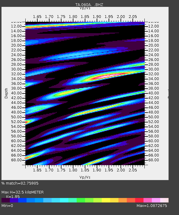
060A Indiantown, FL, USA - Earthquake Result Viewer
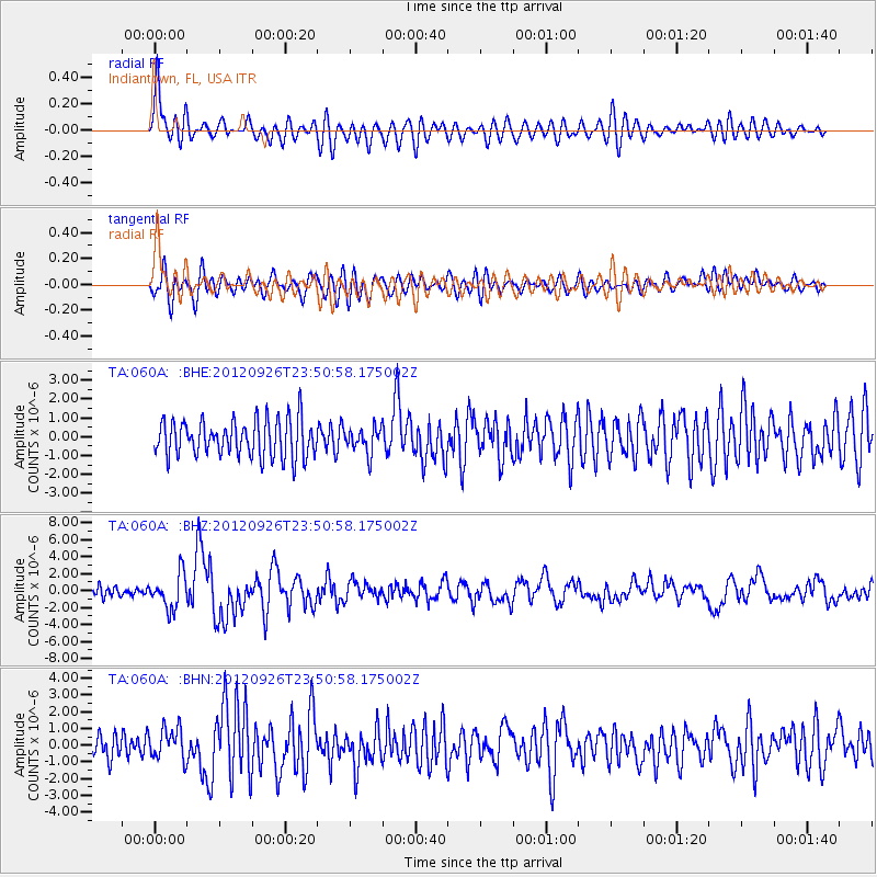
Earthquake location: Andreanof Islands, Aleutian Is.
Earthquake latitude/longitude: 51.6/-178.3
Earthquake time(UTC): 2012/09/26 (270) 23:39:55 GMT
Earthquake Depth: 16 km
Earthquake Magnitude: 6.3 MB, 6.5 MS, 6.4 MW, 6.4 MW
Earthquake Catalog/Contributor: WHDF/NEIC
Network: TA USArray Transportable Network (new EarthScope stations)
Station: 060A Indiantown, FL, USA
Lat/Lon: 27.04 N/80.36 W
Elevation: 9.0 m
Distance: 73.9 deg
Az: 66.82 deg
Baz: 319.99 deg
Ray Param: 0.05265397
Estimated Moho Depth: 32.5 km
Estimated Crust Vp/Vs: 1.95
Assumed Crust Vp: 6.347 km/s
Estimated Crust Vs: 3.255 km/s
Estimated Crust Poisson's Ratio: 0.32
Radial Match: 82.75985 %
Radial Bump: 400
Transverse Match: 64.75651 %
Transverse Bump: 400
SOD ConfigId: 478790
Insert Time: 2013-02-22 23:46:07.848 +0000
GWidth: 2.5
Max Bumps: 400
Tol: 0.001

Signal To Noise

ChannelStoNSTALTA
TA:060A: :BHZ:20120926T23:50:58.175002Z4.5308262.028865E-64.4779145E-7
TA:060A: :BHN:20120926T23:50:58.175002Z1.32454099.486548E-77.1621406E-7
TA:060A: :BHE:20120926T23:50:58.175002Z0.671686776.5974086E-79.822152E-7
Arrivals
Ps5.0 SECOND
PpPs15 SECOND
PsPs/PpSs20 SECOND