
Station TA 060A - Indiantown, FL, USA
Network: TA - USArray Transportable Network (new EarthScope stations)
Nearby stations (2 deg radius)
| Station | Name | (Lat, Lon) | Start / End | Elevation |
| 060A | Indiantown, FL, USA | (27.04, -80.36) | 2012-03-15 / 2599-12-31 | 9.0 m |
| Crust2 Type: | DH,thin Platform 4 km seds. |
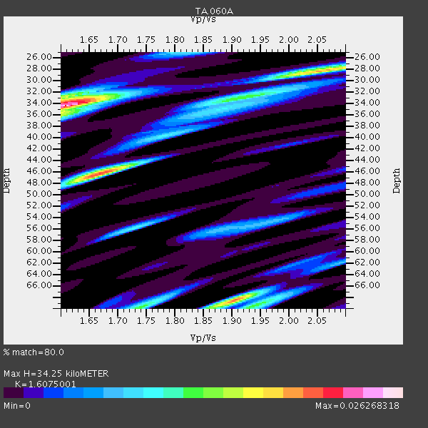
| Thickness Estimate: | 34 km |
| Thickness StdDev: | 14 km |
| Vp/Vs Estimate: | 1.61 |
| Vp/Vs StdDev: | 0.14 |
| Vs Estimate: | 3.948 km/s |
| Poisson's Ratio: | 0.18 |
| Peak Value: | 0.03 |
| Assumed Vp: | 6.347 km/s |
| Ps Weight: | 0.33333334 |
| PpPs Weight: | 0.33333334 |
| PsPs Weight: | 0.33333328 |
| Residual Complexity: | 0.831 |
| Nearby stations H: | +- |
| (2.0 deg) Vp/Vs: | +- |
3 with match > 90% ( 9.090909 %) and 6 with match > 80% ( 18.181818 %) out of 33.
Download stack as xyz text file.
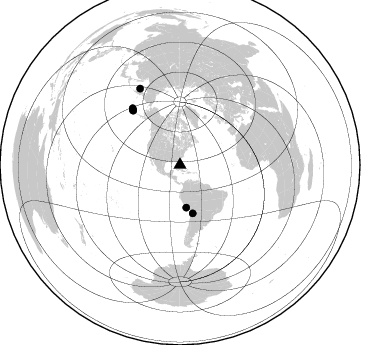
Azimuth Distribution of Events:
Prior Results for this Station
| Study | Thickness | Vp/Vs | Vp | Vs | Poissons Ratio | Extra |
| EARS | 34 km | 1.61 | 6.347 km/s | 3.948 km/s | 0.18 | |
| Crust2.0 | 34 km | 1.79 | 6.347 km/s | 3.553 km/s | 0.27 | DH,thin Platform 4 km seds. |
| Global Maxima | 34 km | 1.61 | 6.347 km/s | 3.948 km/s | 0.18 | amp=0.026268318 |
| Local Maxima 1 | 46 km | 1.67 | 6.347 km/s | 3.806 km/s | 0.22 | amp=0.02114037 |
| Local Maxima 2 | 68 km | 1.91 | 6.347 km/s | 3.327 km/s | 0.31 | amp=0.020104622 |
| Local Maxima 3 | 28 km | 2.05 | 6.347 km/s | 3.1 km/s | 0.34 | amp=0.016116094 |
| Local Maxima 4 | 70 km | 1.74 | 6.347 km/s | 3.658 km/s | 0.25 | amp=0.0127925305 |
| Predicted Arrivals for vertical incidence (zero ray parameter) | |
| Ps | 3.28 SECOND |
| PpPs | 14.07 SECOND |
| PsPs/PpSs | 17.35 SECOND |
Events Processed for this Station
Download zip of receiver functions as SAC
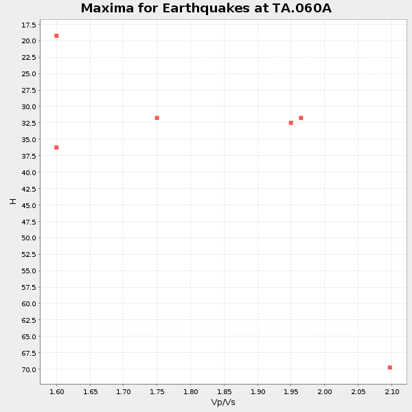
Plot maxima for each earthquake.
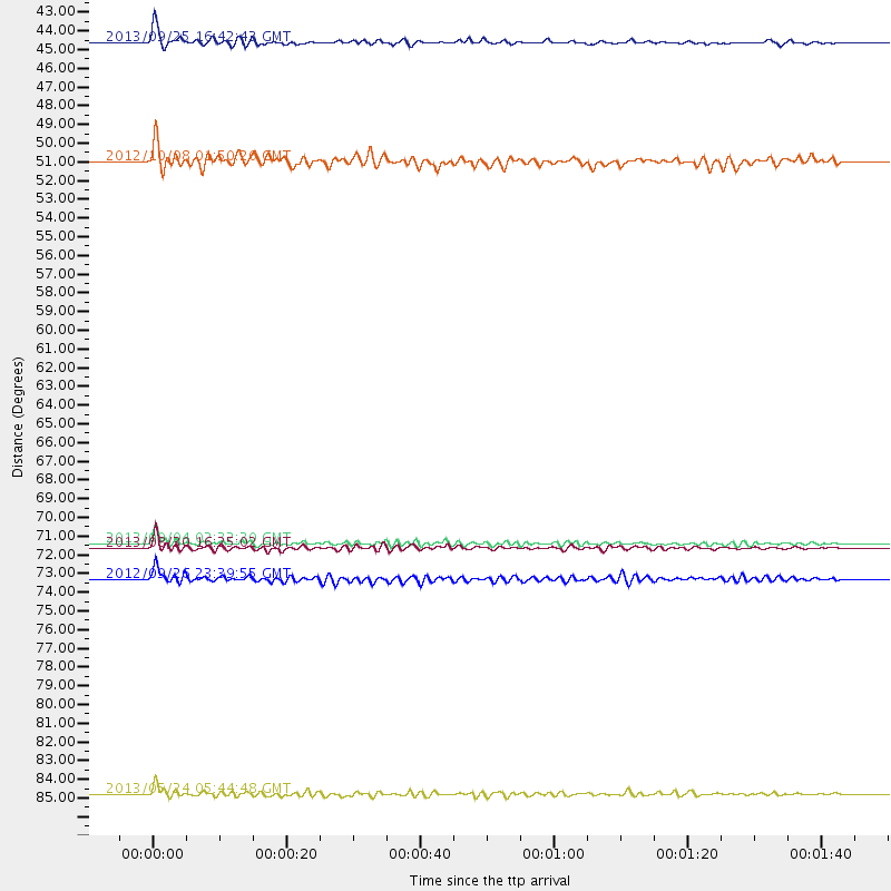
Events Used in the Stack
(6 events)| Radial Match | Distance | Baz | FERegion | Time | Lat/Lon | Depth | Magnitude |
| 94.61296 | 86.4 deg | 332.237 deg | Sea Of Okhotsk | 2013/05/24 05:44:48 GMT | (54.9, 153.2) | 598 km | 8.4 MW, 7.5 MB, 8.3 MW |
| 94.604225 | 72.2 deg | 319.184 deg | Andreanof Islands, Aleutian Is. | 2013/08/30 16:25:02 GMT | (51.5, -175.2) | 29 km | 7.0 MWW, 6.5 ML, 6.8 MI, 6.9 MWC, 6.9 MWB, 7.0 MWW, 7.0 MI, 7.0 MWC |
| 90.250374 | 43.0 deg | 171.728 deg | Near Coast Of Peru | 2013/09/25 16:42:43 GMT | (-15.8, -74.5) | 40 km | 7.1 MWW, 6.8 MI, 7.0 MWB, 7.0 MWC, 7.1 MWW, 7.1 MWC |
| 84.51505 | 71.9 deg | 319.096 deg | Andreanof Islands, Aleutian Is. | 2013/09/04 02:32:30 GMT | (51.6, -174.8) | 20 km | 6.5 MWW, 5.9 ML, 6.3 MWB, 6.5 MI, 6.5 MWC, 6.5 MWW |
| 82.75985 | 73.9 deg | 319.99 deg | Andreanof Islands, Aleutian Is. | 2012/09/26 23:39:55 GMT | (51.6, -178.3) | 16 km | 6.3 MB, 6.5 MS, 6.4 MW, 6.4 MW |
| 81.617645 | 49.9 deg | 165.117 deg | Chile-Bolivia Border Region | 2012/10/08 01:50:26 GMT | (-21.7, -68.2) | 122 km | 6.0 MB, 5.7 MW, 5.8 MW |
Losers
(27 events)| Radial Match | Distance | Baz | FERegion | Time | Lat/Lon | Depth | Magnitude | Reason |
| 79.42468 | 89.0 deg | 331.092 deg | Sea Of Okhotsk | 2013/05/24 14:56:31 GMT | (52.2, 151.4) | 624 km | 6.7 MW, 6.7 MB, 6.7 MW | |
| 78.91683 | 41.5 deg | 173.021 deg | Near Coast Of Peru | 2012/07/02 23:31:37 GMT | (-14.4, -75.6) | 40 km | 6.0 MB, 5.2 MS, 5.7 MW, 5.6 MW | |
| 78.69183 | 45.7 deg | 165.575 deg | Peru-Bolivia Border Region | 2012/05/14 10:00:40 GMT | (-17.7, -69.6) | 106 km | 6.4 MB, 6.2 MW, 6.2 MW | |
| 77.99655 | 55.6 deg | 169.597 deg | Central Chile | 2013/01/30 20:15:43 GMT | (-28.1, -70.7) | 45 km | 6.5 MB, 6.5 MS, 6.8 MW, 6.8 MW | |
| 77.71947 | 39.1 deg | 107.234 deg | Northern Mid-Atlantic Ridge | 2013/06/24 22:04:13 GMT | (10.7, -42.6) | 10 km | 6.5 MW, 6.1 MB, 6.3 MS, 6.6 MW | |
| 77.33399 | 34.7 deg | 102.667 deg | Northern Mid-Atlantic Ridge | 2013/09/05 04:01:36 GMT | (15.2, -45.2) | 10 km | 6.0 MWW, 5.9 MWB, 6.0 MWW, 6.0 MWC | |
| 77.32588 | 35.7 deg | 169.624 deg | Peru-Brazil Border Region | 2012/08/02 09:38:30 GMT | (-8.4, -74.3) | 145 km | 5.9 MB, 6.1 MW, 6.1 MW | |
| 76.44345 | 44.6 deg | 316.698 deg | Queen Charlotte Islands Region | 2013/09/03 20:19:06 GMT | (51.2, -130.4) | 2.7 km | 6.1 MWW, 6.0 MWB, 6.1 MWW, 6.1 MWC, 6.2 MI, 6.2 MWC | |
| 72.83631 | 87.2 deg | 327.613 deg | Kuril Islands | 2013/03/01 13:20:49 GMT | (51.0, 157.4) | 29 km | 6.3 MB, 6.3 MS, 6.5 MW, 6.4 MW | |
| 70.78614 | 87.7 deg | 331.199 deg | Sea Of Okhotsk | 2013/10/01 03:38:21 GMT | (53.2, 152.8) | 573 km | 6.7 MWW, 6.7 MWC, 6.8 MWC, 6.8 MWB | |
| 69.76621 | 87.2 deg | 327.661 deg | Kuril Islands | 2013/02/28 14:05:50 GMT | (51.0, 157.3) | 41 km | 6.4 MB, 6.7 MS, 6.9 MW, 6.8 MW | |
| 68.0127 | 86.0 deg | 326.317 deg | East Of Kuril Islands | 2013/03/24 04:18:33 GMT | (50.7, 160.2) | 8.0 km | 6.1 MB, 5.5 MS, 5.9 MW, 6.1 MW | |
| 66.48358 | 45.8 deg | 317.939 deg | Queen Charlotte Islands Region | 2012/10/30 02:49:02 GMT | (52.4, -131.9) | 9.0 km | 5.8 MB, 6.0 MS, 6.2 MW, 6.2 MW | |
| 65.81612 | 45.9 deg | 317.808 deg | Queen Charlotte Islands Region | 2012/10/28 19:09:53 GMT | (52.3, -132.1) | 10 km | 5.6 MB, 5.8 MW, 5.5 MW | |
| 64.3259 | 93.6 deg | 327.194 deg | Kuril Islands | 2013/04/19 03:05:52 GMT | (46.2, 150.8) | 110 km | 7.2 MW, 7.1 MB, 7.2 MW | |
| 64.308174 | 43.3 deg | 167.834 deg | Southern Peru | 2013/07/17 02:37:43 GMT | (-15.7, -71.7) | 7.0 km | 6.0 MW, 5.6 MB, 5.8 MS, 5.8 MW | |
| 64.01487 | 32.3 deg | 182.919 deg | Near Coast Of Northern Peru | 2013/08/12 09:49:32 GMT | (-5.4, -81.9) | 10 km | 6.2 MWW, 6.1 MWB, 6.2 MWW, 6.2 MWC, 6.3 MWC | |
| 62.279476 | 71.9 deg | 319.117 deg | Andreanof Islands, Aleutian Is. | 2013/09/04 06:16:49 GMT | (51.6, -174.8) | 21 km | 5.7 MWW, 5.5 ML, 5.5 MI, 5.7 MWB, 5.7 MWW, 5.8 MWC | |
| 57.517056 | 50.3 deg | 165.791 deg | Northern Chile | 2013/08/23 08:34:06 GMT | (-22.3, -68.6) | 111 km | 5.8 MWW, 5.7 MWD, 5.8 MWW, 5.8 MWB, 5.8 MWC | |
| 57.113373 | 72.1 deg | 318.822 deg | Andreanof Islands, Aleutian Is. | 2013/08/31 06:38:36 GMT | (51.2, -174.9) | 18 km | 6.0 MWW, 5.5 ML, 5.9 MWB, 5.9 MWC, 6.0 MWC, 6.0 MI, 6.0 MWW | |
| 56.822304 | 53.3 deg | 168.961 deg | Near Coast Of Northern Chile | 2012/05/19 08:35:10 GMT | (-25.7, -70.6) | 28 km | 5.7 MB, 5.5 MS, 5.8 MW, 5.9 MW | |
| 55.162613 | 31.6 deg | 171.883 deg | Northern Peru | 2012/11/28 03:09:48 GMT | (-4.5, -76.1) | 118 km | 5.9 MB, 5.6 MW, 5.7 MW | |
| 54.919823 | 51.4 deg | 159.94 deg | Salta Province, Argentina | 2012/06/02 07:52:53 GMT | (-22.1, -63.6) | 527 km | 5.8 MB, 5.9 MW, 6.0 MW | |
| 53.348892 | 85.3 deg | 171.952 deg | Drake Passage | 2012/04/14 10:56:19 GMT | (-57.7, -65.3) | 15 km | 6.1 MB, 6.1 MS, 6.2 MW, 6.2 MW | |
| 52.90007 | 85.4 deg | 120.585 deg | South Atlantic Ocean | 2012/06/29 15:31:46 GMT | (-24.7, -9.7) | 10 km | 6.0 MB, 5.2 MS, 5.8 MW, 5.8 MW | |
| 52.734447 | 57.1 deg | 161.778 deg | Santiago Del Estero Prov., Arg. | 2013/02/22 12:01:58 GMT | (-27.9, -63.1) | 575 km | 5.8 MB, 6.1 MW, 6.2 MW | |
| 47.641617 | 42.4 deg | 315.123 deg | Vancouver Island, Canada Region | 2013/08/04 13:22:27 GMT | (49.7, -127.4) | 10 km | 5.6 MB, 5.5 MW |
