You are here: Home > Network List > TA - USArray Transportable Network (new EarthScope stations) Stations List
> Station 060A Indiantown, FL, USA > Earthquake Result Viewer
060A Indiantown, FL, USA - Earthquake Result Viewer
| Earthquake location: |
Chile-Bolivia Border Region |
| Earthquake latitude/longitude: |
-21.7/-68.2 |
| Earthquake time(UTC): |
2012/10/08 (282) 01:50:26 GMT |
| Earthquake Depth: |
122 km |
| Earthquake Magnitude: |
6.0 MB, 5.7 MW, 5.8 MW |
| Earthquake Catalog/Contributor: |
WHDF/NEIC |
|
| Network: |
TA USArray Transportable Network (new EarthScope stations) |
| Station: |
060A Indiantown, FL, USA |
| Lat/Lon: |
27.04 N/80.36 W |
| Elevation: |
9.0 m |
|
| Distance: |
49.9 deg |
| Az: |
345.736 deg |
| Baz: |
165.117 deg |
| Ray Param: |
0.06799964 |
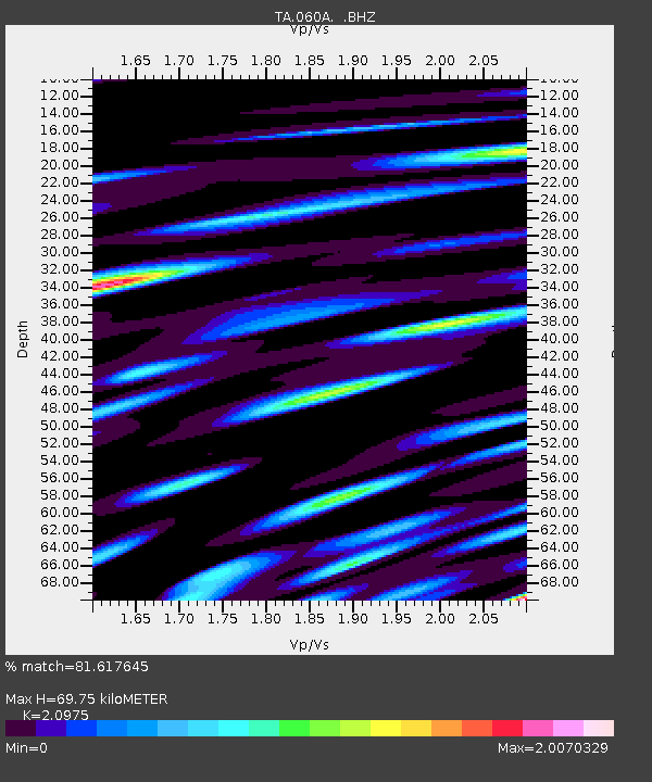
| Estimated Moho Depth: |
69.75 km |
| Estimated Crust Vp/Vs: |
2.10 |
| Assumed Crust Vp: |
6.347 km/s |
| Estimated Crust Vs: |
3.026 km/s |
| Estimated Crust Poisson's Ratio: |
0.35 |
|
| Radial Match: |
81.617645 % |
| Radial Bump: |
400 |
| Transverse Match: |
60.043472 % |
| Transverse Bump: |
400 |
| SOD ConfigId: |
478790 |
| Insert Time: |
2013-02-23 02:58:56.909 +0000 |
| GWidth: |
2.5 |
| Max Bumps: |
400 |
| Tol: |
0.001 |
|
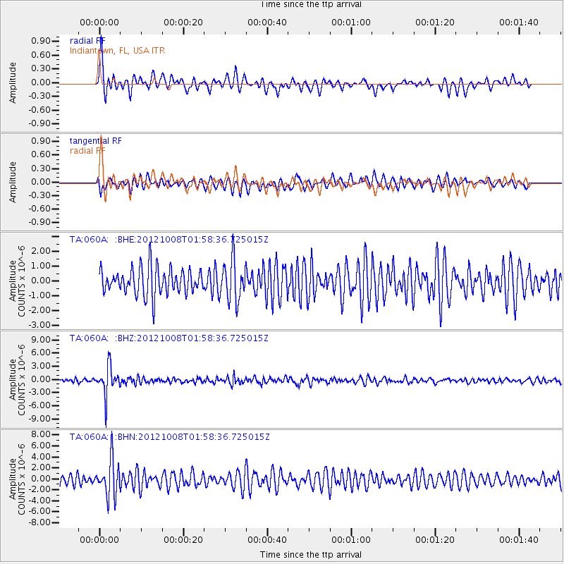
Signal To Noise
| Channel | StoN | STA | LTA |
| TA:060A: :BHZ:20121008T01:58:36.725015Z | 7.113845 | 3.2975477E-6 | 4.635394E-7 |
| TA:060A: :BHN:20121008T01:58:36.725015Z | 5.000978 | 3.3051717E-6 | 6.60905E-7 |
| TA:060A: :BHE:20121008T01:58:36.725015Z | 1.5756462 | 1.3625088E-6 | 8.6473017E-7 |
| Arrivals |
| Ps | 13 SECOND |
| PpPs | 32 SECOND |
| PsPs/PpSs | 45 SECOND |


