You are here: Home > Network List > IC - New China Digital Seismograph Network Stations List
> Station HIA Hailar, Neimenggu Province, China > Earthquake Result Viewer
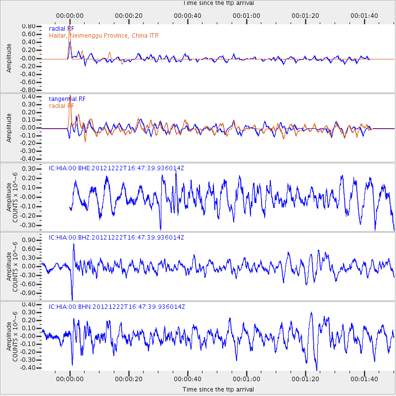
HIA Hailar, Neimenggu Province, China - Earthquake Result Viewer
*The percent match for this event was below the threshold and hence no stack was calculated.
| Earthquake location: |
Myanmar |
| Earthquake latitude/longitude: |
22.4/94.8 |
| Earthquake time(UTC): |
2012/12/22 (357) 16:41:45 GMT |
| Earthquake Depth: |
134 km |
| Earthquake Magnitude: |
5.5 MW, 5.4 MB, 5.5 MW |
| Earthquake Catalog/Contributor: |
WHDF/NEIC |
|
| Network: |
IC New China Digital Seismograph Network |
| Station: |
HIA Hailar, Neimenggu Province, China |
| Lat/Lon: |
49.27 N/119.74 E |
| Elevation: |
620 m |
|
| Distance: |
33.3 deg |
| Az: |
30.265 deg |
| Baz: |
225.387 deg |
| Ray Param: |
$rayparam |
*The percent match for this event was below the threshold and hence was not used in the summary stack. |
|
| Radial Match: |
50.134754 % |
| Radial Bump: |
400 |
| Transverse Match: |
63.42591 % |
| Transverse Bump: |
400 |
| SOD ConfigId: |
491031 |
| Insert Time: |
2013-04-05 11:47:17.137 +0000 |
| GWidth: |
2.5 |
| Max Bumps: |
400 |
| Tol: |
0.001 |
|
Signal To Noise
| Channel | StoN | STA | LTA |
| IC:HIA:00:BHZ:20121222T16:47:39.936014Z | 2.8299332 | 3.469934E-7 | 1.226154E-7 |
| IC:HIA:00:BHN:20121222T16:47:39.936014Z | 2.2365267 | 1.4157317E-7 | 6.3300455E-8 |
| IC:HIA:00:BHE:20121222T16:47:39.936014Z | 1.33231 | 1.3048914E-7 | 9.794203E-8 |
| Arrivals |
| Ps | |
| PpPs | |
| PsPs/PpSs | |


