You are here: Home > Network List > IC - New China Digital Seismograph Network Stations List
> Station HIA Hailar, Neimenggu Province, China > Earthquake Result Viewer
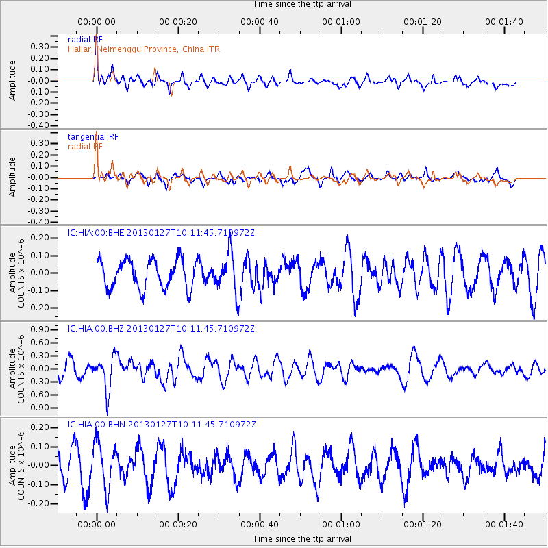
HIA Hailar, Neimenggu Province, China - Earthquake Result Viewer
*The percent match for this event was below the threshold and hence no stack was calculated.
| Earthquake location: |
Tonga Islands |
| Earthquake latitude/longitude: |
-16.1/-173.2 |
| Earthquake time(UTC): |
2013/01/27 (027) 09:59:29 GMT |
| Earthquake Depth: |
19 km |
| Earthquake Magnitude: |
5.7 MB, 5.5 MS, 5.7 MW, 5.7 MW |
| Earthquake Catalog/Contributor: |
WHDF/NEIC |
|
| Network: |
IC New China Digital Seismograph Network |
| Station: |
HIA Hailar, Neimenggu Province, China |
| Lat/Lon: |
49.27 N/119.74 E |
| Elevation: |
620 m |
|
| Distance: |
87.9 deg |
| Az: |
322.882 deg |
| Baz: |
117.68 deg |
| Ray Param: |
$rayparam |
*The percent match for this event was below the threshold and hence was not used in the summary stack. |
|
| Radial Match: |
58.009346 % |
| Radial Bump: |
400 |
| Transverse Match: |
46.017567 % |
| Transverse Bump: |
388 |
| SOD ConfigId: |
494114 |
| Insert Time: |
2013-04-24 03:41:02.557 +0000 |
| GWidth: |
2.5 |
| Max Bumps: |
400 |
| Tol: |
0.001 |
|
Signal To Noise
| Channel | StoN | STA | LTA |
| IC:HIA:00:BHZ:20130127T10:11:45.710972Z | 2.2900538 | 3.976056E-7 | 1.7362281E-7 |
| IC:HIA:00:BHN:20130127T10:11:45.710972Z | 1.3366847 | 1.205382E-7 | 9.0177E-8 |
| IC:HIA:00:BHE:20130127T10:11:45.710972Z | 1.4287663 | 1.1656829E-7 | 8.158668E-8 |
| Arrivals |
| Ps | |
| PpPs | |
| PsPs/PpSs | |


