You are here: Home > Network List > TA - USArray Transportable Network (new EarthScope stations) Stations List
> Station 858A St. Cloud, FL, USA > Earthquake Result Viewer
858A St. Cloud, FL, USA - Earthquake Result Viewer
| Earthquake location: |
Central Chile |
| Earthquake latitude/longitude: |
-28.1/-70.7 |
| Earthquake time(UTC): |
2013/01/30 (030) 20:15:43 GMT |
| Earthquake Depth: |
45 km |
| Earthquake Magnitude: |
6.5 MB, 6.5 MS, 6.8 MW, 6.8 MW |
| Earthquake Catalog/Contributor: |
WHDF/NEIC |
|
| Network: |
TA USArray Transportable Network (new EarthScope stations) |
| Station: |
858A St. Cloud, FL, USA |
| Lat/Lon: |
28.21 N/81.36 W |
| Elevation: |
27 m |
|
| Distance: |
56.9 deg |
| Az: |
348.714 deg |
| Baz: |
168.702 deg |
| Ray Param: |
0.063725494 |
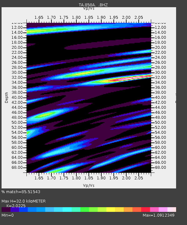
| Estimated Moho Depth: |
32.0 km |
| Estimated Crust Vp/Vs: |
2.02 |
| Assumed Crust Vp: |
6.134 km/s |
| Estimated Crust Vs: |
3.033 km/s |
| Estimated Crust Poisson's Ratio: |
0.34 |
|
| Radial Match: |
85.51543 % |
| Radial Bump: |
400 |
| Transverse Match: |
62.33237 % |
| Transverse Bump: |
400 |
| SOD ConfigId: |
494114 |
| Insert Time: |
2013-04-27 04:08:46.575 +0000 |
| GWidth: |
2.5 |
| Max Bumps: |
400 |
| Tol: |
0.001 |
|
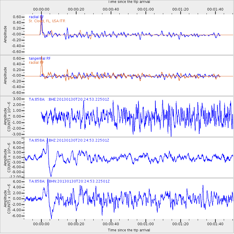
Signal To Noise
| Channel | StoN | STA | LTA |
| TA:858A: :BHZ:20130130T20:24:53.22501Z | 8.271409 | 5.073591E-6 | 6.13389E-7 |
| TA:858A: :BHN:20130130T20:24:53.22501Z | 3.8394241 | 2.7696587E-6 | 7.213735E-7 |
| TA:858A: :BHE:20130130T20:24:53.22501Z | 1.1954178 | 8.629989E-7 | 7.2192245E-7 |
| Arrivals |
| Ps | 5.6 SECOND |
| PpPs | 15 SECOND |
| PsPs/PpSs | 21 SECOND |


