You are here: Home > Network List > OE - Austrian Seismic Network Stations List
> Station DAVA Damuels, Vorarlberg, Austria > Earthquake Result Viewer
DAVA Damuels, Vorarlberg, Austria - Earthquake Result Viewer
| Earthquake location: |
Hokkaido, Japan Region |
| Earthquake latitude/longitude: |
42.8/143.1 |
| Earthquake time(UTC): |
2013/02/02 (033) 14:17:35 GMT |
| Earthquake Depth: |
107 km |
| Earthquake Magnitude: |
6.4 MB, 6.9 MW, 6.9 MW |
| Earthquake Catalog/Contributor: |
WHDF/NEIC |
|
| Network: |
OE Austrian Seismic Network |
| Station: |
DAVA Damuels, Vorarlberg, Austria |
| Lat/Lon: |
47.29 N/9.88 E |
| Elevation: |
1602 m |
|
| Distance: |
81.2 deg |
| Az: |
329.865 deg |
| Baz: |
32.889 deg |
| Ray Param: |
0.047486234 |
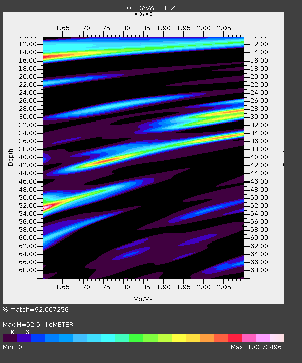
| Estimated Moho Depth: |
52.5 km |
| Estimated Crust Vp/Vs: |
1.60 |
| Assumed Crust Vp: |
6.416 km/s |
| Estimated Crust Vs: |
4.01 km/s |
| Estimated Crust Poisson's Ratio: |
0.18 |
|
| Radial Match: |
92.007256 % |
| Radial Bump: |
400 |
| Transverse Match: |
76.18479 % |
| Transverse Bump: |
400 |
| SOD ConfigId: |
494114 |
| Insert Time: |
2013-04-27 06:25:12.185 +0000 |
| GWidth: |
2.5 |
| Max Bumps: |
400 |
| Tol: |
0.001 |
|

Signal To Noise
| Channel | StoN | STA | LTA |
| OE:DAVA: :BHZ:20130202T14:29:08.197017Z | 8.257712 | 3.2333255E-6 | 3.915522E-7 |
| OE:DAVA: :BHN:20130202T14:29:08.197017Z | 5.368526 | 1.2614529E-6 | 2.3497192E-7 |
| OE:DAVA: :BHE:20130202T14:29:08.197017Z | 3.3483608 | 6.9384237E-7 | 2.0721852E-7 |
| Arrivals |
| Ps | 5.1 SECOND |
| PpPs | 21 SECOND |
| PsPs/PpSs | 26 SECOND |


