You are here: Home > Network List > TA - USArray Transportable Network (new EarthScope stations) Stations List
> Station 758A Lake Helen, FL, USA > Earthquake Result Viewer
758A Lake Helen, FL, USA - Earthquake Result Viewer

| Earthquake location: |
Kuril Islands |
| Earthquake latitude/longitude: |
51.0/157.3 |
| Earthquake time(UTC): |
2013/02/28 (059) 14:05:50 GMT |
| Earthquake Depth: |
41 km |
| Earthquake Magnitude: |
6.4 MB, 6.7 MS, 6.9 MW, 6.8 MW |
| Earthquake Catalog/Contributor: |
WHDF/NEIC |
|
| Network: |
TA USArray Transportable Network (new EarthScope stations) |
| Station: |
758A Lake Helen, FL, USA |
| Lat/Lon: |
28.96 N/81.20 W |
| Elevation: |
16 m |
|
| Distance: |
85.2 deg |
| Az: |
48.56 deg |
| Baz: |
327.243 deg |
| Ray Param: |
0.04486116 |
| Estimated Moho Depth: |
38.25 km |
| Estimated Crust Vp/Vs: |
1.81 |
| Assumed Crust Vp: |
6.134 km/s |
| Estimated Crust Vs: |
3.398 km/s |
| Estimated Crust Poisson's Ratio: |
0.28 |
|
| Radial Match: |
81.534805 % |
| Radial Bump: |
400 |
| Transverse Match: |
72.90674 % |
| Transverse Bump: |
400 |
| SOD ConfigId: |
494114 |
| Insert Time: |
2013-05-15 05:23:34.002 +0000 |
| GWidth: |
2.5 |
| Max Bumps: |
400 |
| Tol: |
0.001 |
|
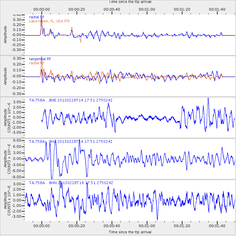
Signal To Noise
| Channel | StoN | STA | LTA |
| TA:758A: :BHZ:20130228T14:17:51.275024Z | 5.962983 | 3.5283097E-6 | 5.9170213E-7 |
| TA:758A: :BHN:20130228T14:17:51.275024Z | 1.7229025 | 9.3061095E-7 | 5.4014134E-7 |
| TA:758A: :BHE:20130228T14:17:51.275024Z | 1.0657537 | 8.314558E-7 | 7.801575E-7 |
| Arrivals |
| Ps | 5.1 SECOND |
| PpPs | 17 SECOND |
| PsPs/PpSs | 22 SECOND |


