You are here: Home > Network List > TA - USArray Transportable Network (new EarthScope stations) Stations List
> Station 658A Bunnell, FL, USA > Earthquake Result Viewer
658A Bunnell, FL, USA - Earthquake Result Viewer
| Earthquake location: |
Kuril Islands |
| Earthquake latitude/longitude: |
51.0/157.4 |
| Earthquake time(UTC): |
2013/03/01 (060) 13:20:49 GMT |
| Earthquake Depth: |
29 km |
| Earthquake Magnitude: |
6.3 MB, 6.3 MS, 6.5 MW, 6.4 MW |
| Earthquake Catalog/Contributor: |
WHDF/NEIC |
|
| Network: |
TA USArray Transportable Network (new EarthScope stations) |
| Station: |
658A Bunnell, FL, USA |
| Lat/Lon: |
29.42 N/81.26 W |
| Elevation: |
11 m |
|
| Distance: |
84.7 deg |
| Az: |
48.446 deg |
| Baz: |
327.147 deg |
| Ray Param: |
0.045229238 |
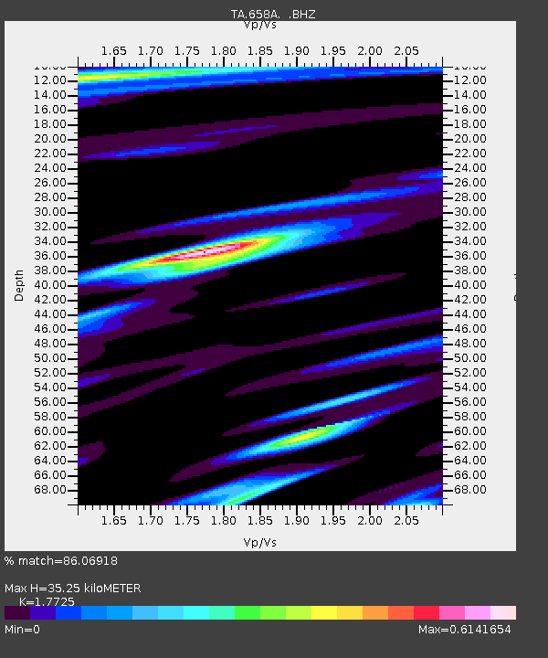
| Estimated Moho Depth: |
35.25 km |
| Estimated Crust Vp/Vs: |
1.77 |
| Assumed Crust Vp: |
6.134 km/s |
| Estimated Crust Vs: |
3.461 km/s |
| Estimated Crust Poisson's Ratio: |
0.27 |
|
| Radial Match: |
86.06918 % |
| Radial Bump: |
400 |
| Transverse Match: |
42.518826 % |
| Transverse Bump: |
400 |
| SOD ConfigId: |
494114 |
| Insert Time: |
2013-05-15 07:22:12.872 +0000 |
| GWidth: |
2.5 |
| Max Bumps: |
400 |
| Tol: |
0.001 |
|
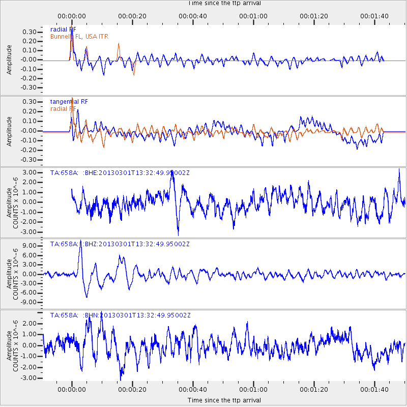
Signal To Noise
| Channel | StoN | STA | LTA |
| TA:658A: :BHZ:20130301T13:32:49.95002Z | 9.941086 | 4.4124636E-6 | 4.4386135E-7 |
| TA:658A: :BHN:20130301T13:32:49.95002Z | 1.996451 | 1.025181E-6 | 5.135017E-7 |
| TA:658A: :BHE:20130301T13:32:49.95002Z | 2.5759535 | 1.6416822E-6 | 6.373105E-7 |
| Arrivals |
| Ps | 4.5 SECOND |
| PpPs | 16 SECOND |
| PsPs/PpSs | 20 SECOND |


