You are here: Home > Network List > AK - Alaska Regional Network Stations List
> Station PTPK Patty Peak Repeater, AK, USA > Earthquake Result Viewer
PTPK Patty Peak Repeater, AK, USA - Earthquake Result Viewer
| Earthquake location: |
Southern Iran |
| Earthquake latitude/longitude: |
28.0/62.0 |
| Earthquake time(UTC): |
2013/04/16 (106) 10:44:20 GMT |
| Earthquake Depth: |
80 km |
| Earthquake Magnitude: |
7.7 MW, 7.0 MB, 7.7 MW |
| Earthquake Catalog/Contributor: |
NEIC PDE/NEIC PDE-W |
|
| Network: |
AK Alaska Regional Network |
| Station: |
PTPK Patty Peak Repeater, AK, USA |
| Lat/Lon: |
61.19 N/142.47 W |
| Elevation: |
1933 m |
|
| Distance: |
88.9 deg |
| Az: |
11.575 deg |
| Baz: |
338.523 deg |
| Ray Param: |
0.042089727 |
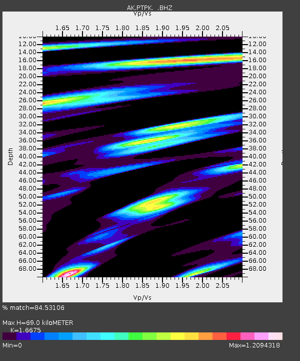
| Estimated Moho Depth: |
69.0 km |
| Estimated Crust Vp/Vs: |
1.67 |
| Assumed Crust Vp: |
6.566 km/s |
| Estimated Crust Vs: |
3.938 km/s |
| Estimated Crust Poisson's Ratio: |
0.22 |
|
| Radial Match: |
84.53106 % |
| Radial Bump: |
400 |
| Transverse Match: |
86.64643 % |
| Transverse Bump: |
400 |
| SOD ConfigId: |
512894 |
| Insert Time: |
2013-09-13 07:13:05.788 +0000 |
| GWidth: |
2.5 |
| Max Bumps: |
400 |
| Tol: |
0.001 |
|

Signal To Noise
| Channel | StoN | STA | LTA |
| AK:PTPK: :BHZ:20130416T10:56:34.468025Z | 4.24994 | 7.5532535E-7 | 1.7772612E-7 |
| AK:PTPK: :BHN:20130416T10:56:34.468025Z | 1.3528552 | 2.9248454E-7 | 2.1619796E-7 |
| AK:PTPK: :BHE:20130416T10:56:34.468025Z | 0.8651924 | 2.41186E-7 | 2.7876575E-7 |
| Arrivals |
| Ps | 7.2 SECOND |
| PpPs | 27 SECOND |
| PsPs/PpSs | 35 SECOND |


