You are here: Home > Network List > PS - Pacific21 Stations List
> Station BAG 7aguio, Philippines > Earthquake Result Viewer
BAG 7aguio, Philippines - Earthquake Result Viewer
| Earthquake location: |
New Ireland Region, P.N.G. |
| Earthquake latitude/longitude: |
-4.6/153.7 |
| Earthquake time(UTC): |
1999/01/28 (028) 18:24:25 GMT |
| Earthquake Depth: |
101 km |
| Earthquake Magnitude: |
5.6 MB, 6.4 MW, 6.3 MW |
| Earthquake Catalog/Contributor: |
WHDF/NEIC |
|
| Network: |
PS Pacific21 |
| Station: |
BAG 7aguio, Philippines |
| Lat/Lon: |
16.41 N/120.58 E |
| Elevation: |
1507 m |
|
| Distance: |
38.8 deg |
| Az: |
303.271 deg |
| Baz: |
119.729 deg |
| Ray Param: |
0.07502009 |
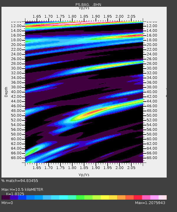
| Estimated Moho Depth: |
10.5 km |
| Estimated Crust Vp/Vs: |
1.83 |
| Assumed Crust Vp: |
6.468 km/s |
| Estimated Crust Vs: |
3.529 km/s |
| Estimated Crust Poisson's Ratio: |
0.29 |
|
| Radial Match: |
94.83455 % |
| Radial Bump: |
351 |
| Transverse Match: |
90.89704 % |
| Transverse Bump: |
400 |
| SOD ConfigId: |
4480 |
| Insert Time: |
2010-02-27 02:54:19.780 +0000 |
| GWidth: |
2.5 |
| Max Bumps: |
400 |
| Tol: |
0.001 |
|
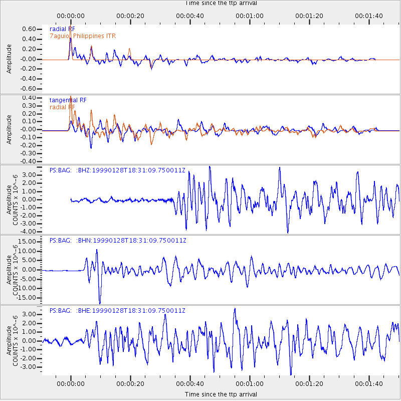
Signal To Noise
| Channel | StoN | STA | LTA |
| PS:BAG: :BHN:19990128T18:31:09.750011Z | 4.2543917 | 5.674412E-7 | 1.3337775E-7 |
| PS:BAG: :BHE:19990128T18:31:09.750011Z | 1.3479346 | 1.9501518E-7 | 1.4467705E-7 |
| PS:BAG: :BHZ:19990128T18:31:09.750011Z | 1.0530311 | 1.5450951E-7 | 1.4672834E-7 |
| Arrivals |
| Ps | 1.4 SECOND |
| PpPs | 4.3 SECOND |
| PsPs/PpSs | 5.7 SECOND |


