You are here: Home > Network List > PS - Pacific21 Stations List
> Station BAG 7aguio, Philippines > Earthquake Result Viewer
BAG 7aguio, Philippines - Earthquake Result Viewer
| Earthquake location: |
Turkmenistan |
| Earthquake latitude/longitude: |
39.6/54.8 |
| Earthquake time(UTC): |
2000/12/06 (341) 17:11:06 GMT |
| Earthquake Depth: |
30 km |
| Earthquake Magnitude: |
6.7 MB, 7.5 MS, 7.0 MW, 6.9 ME |
| Earthquake Catalog/Contributor: |
WHDF/NEIC |
|
| Network: |
PS Pacific21 |
| Station: |
BAG 7aguio, Philippines |
| Lat/Lon: |
16.41 N/120.58 E |
| Elevation: |
1507 m |
|
| Distance: |
61.2 deg |
| Az: |
92.143 deg |
| Baz: |
306.407 deg |
| Ray Param: |
0.061011467 |
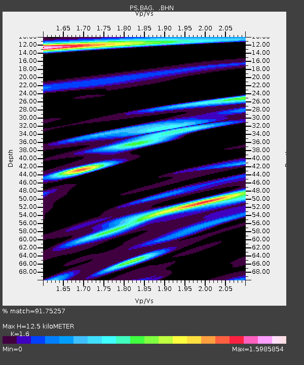
| Estimated Moho Depth: |
12.5 km |
| Estimated Crust Vp/Vs: |
1.60 |
| Assumed Crust Vp: |
6.468 km/s |
| Estimated Crust Vs: |
4.042 km/s |
| Estimated Crust Poisson's Ratio: |
0.18 |
|
| Radial Match: |
91.75257 % |
| Radial Bump: |
400 |
| Transverse Match: |
86.91114 % |
| Transverse Bump: |
400 |
| SOD ConfigId: |
20082 |
| Insert Time: |
2010-02-27 02:54:27.129 +0000 |
| GWidth: |
2.5 |
| Max Bumps: |
400 |
| Tol: |
0.001 |
|

Signal To Noise
| Channel | StoN | STA | LTA |
| PS:BAG: :BHN:20001206T17:20:47.150Z | 1.600931 | 6.3051647E-7 | 3.938436E-7 |
| PS:BAG: :BHE:20001206T17:20:47.150Z | 1.7141305 | 8.1616884E-7 | 4.761416E-7 |
| PS:BAG: :BHZ:20001206T17:20:47.150Z | 4.932396 | 1.4404153E-6 | 2.9203156E-7 |
| Arrivals |
| Ps | 1.2 SECOND |
| PpPs | 4.8 SECOND |
| PsPs/PpSs | 6.0 SECOND |


