You are here: Home > Network List > PS - Pacific21 Stations List
> Station BAG 7aguio, Philippines > Earthquake Result Viewer
BAG 7aguio, Philippines - Earthquake Result Viewer

| Earthquake location: |
Bismarck Sea |
| Earthquake latitude/longitude: |
-4.0/146.6 |
| Earthquake time(UTC): |
2000/04/30 (121) 21:08:35 GMT |
| Earthquake Depth: |
10 km |
| Earthquake Magnitude: |
5.3 MB, 5.7 MS, 5.9 MW, 5.9 MW |
| Earthquake Catalog/Contributor: |
WHDF/NEIC |
|
| Network: |
PS Pacific21 |
| Station: |
BAG 7aguio, Philippines |
| Lat/Lon: |
16.41 N/120.58 E |
| Elevation: |
1507 m |
|
| Distance: |
32.7 deg |
| Az: |
308.94 deg |
| Baz: |
126.053 deg |
| Ray Param: |
0.07853371 |
| Estimated Moho Depth: |
20.75 km |
| Estimated Crust Vp/Vs: |
1.62 |
| Assumed Crust Vp: |
6.468 km/s |
| Estimated Crust Vs: |
4.005 km/s |
| Estimated Crust Poisson's Ratio: |
0.19 |
|
| Radial Match: |
80.75486 % |
| Radial Bump: |
400 |
| Transverse Match: |
81.35306 % |
| Transverse Bump: |
400 |
| SOD ConfigId: |
3753 |
| Insert Time: |
2010-02-27 02:54:33.998 +0000 |
| GWidth: |
2.5 |
| Max Bumps: |
400 |
| Tol: |
0.001 |
|
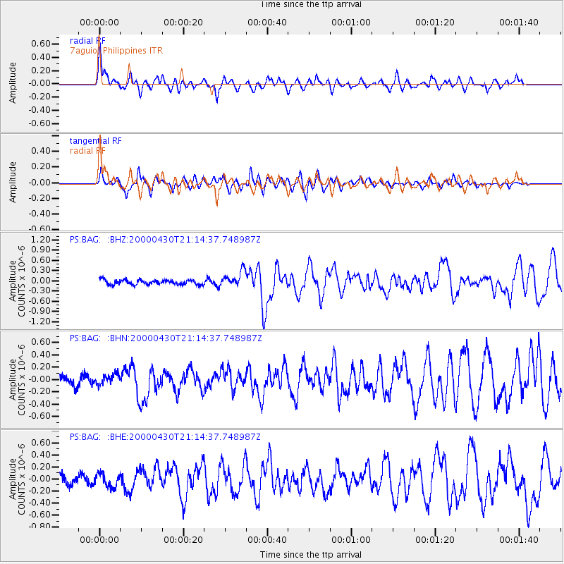
Signal To Noise
| Channel | StoN | STA | LTA |
| PS:BAG: :BHN:20000430T21:14:37.748987Z | 1.2155037 | 8.8546116E-8 | 7.284726E-8 |
| PS:BAG: :BHE:20000430T21:14:37.748987Z | 1.3829144 | 1.1071832E-7 | 8.006159E-8 |
| PS:BAG: :BHZ:20000430T21:14:37.748987Z | 3.4613886 | 2.3683558E-7 | 6.842213E-8 |
| Arrivals |
| Ps | 2.2 SECOND |
| PpPs | 7.7 SECOND |
| PsPs/PpSs | 9.8 SECOND |


