You are here: Home > Network List > PS - Pacific21 Stations List
> Station BAG 7aguio, Philippines > Earthquake Result Viewer
BAG 7aguio, Philippines - Earthquake Result Viewer
| Earthquake location: |
Fiji Islands |
| Earthquake latitude/longitude: |
-15.7/179.8 |
| Earthquake time(UTC): |
2000/09/14 (258) 14:59:57 GMT |
| Earthquake Depth: |
33 km |
| Earthquake Magnitude: |
5.7 MB, 6.2 MS, 6.3 MW, 6.2 MW |
| Earthquake Catalog/Contributor: |
WHDF/NEIC |
|
| Network: |
PS Pacific21 |
| Station: |
BAG 7aguio, Philippines |
| Lat/Lon: |
16.41 N/120.58 E |
| Elevation: |
1507 m |
|
| Distance: |
66.6 deg |
| Az: |
296.035 deg |
| Baz: |
115.642 deg |
| Ray Param: |
0.05746019 |
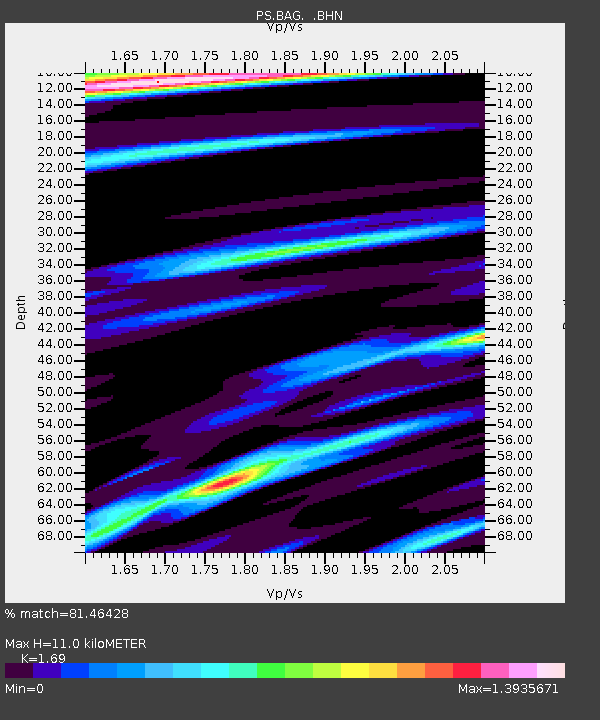
| Estimated Moho Depth: |
11.0 km |
| Estimated Crust Vp/Vs: |
1.69 |
| Assumed Crust Vp: |
6.468 km/s |
| Estimated Crust Vs: |
3.827 km/s |
| Estimated Crust Poisson's Ratio: |
0.23 |
|
| Radial Match: |
81.46428 % |
| Radial Bump: |
400 |
| Transverse Match: |
71.424095 % |
| Transverse Bump: |
400 |
| SOD ConfigId: |
3744 |
| Insert Time: |
2010-02-27 02:54:58.272 +0000 |
| GWidth: |
2.5 |
| Max Bumps: |
400 |
| Tol: |
0.001 |
|
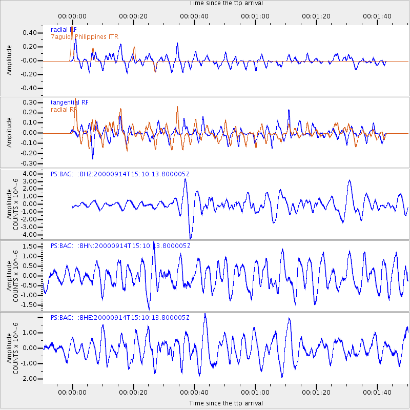
Signal To Noise
| Channel | StoN | STA | LTA |
| PS:BAG: :BHN:20000914T15:10:13.800005Z | 0.8052989 | 2.4546384E-7 | 3.048108E-7 |
| PS:BAG: :BHE:20000914T15:10:13.800005Z | 1.2020628 | 4.0695656E-7 | 3.385485E-7 |
| PS:BAG: :BHZ:20000914T15:10:13.800005Z | 1.2648824 | 4.1517185E-7 | 3.282296E-7 |
| Arrivals |
| Ps | 1.2 SECOND |
| PpPs | 4.4 SECOND |
| PsPs/PpSs | 5.6 SECOND |


