You are here: Home > Network List > PS - Pacific21 Stations List
> Station BAG 7aguio, Philippines > Earthquake Result Viewer
BAG 7aguio, Philippines - Earthquake Result Viewer
| Earthquake location: |
Vanuatu Islands |
| Earthquake latitude/longitude: |
-19.9/168.2 |
| Earthquake time(UTC): |
1999/04/02 (092) 17:05:47 GMT |
| Earthquake Depth: |
10 km |
| Earthquake Magnitude: |
6.1 MB, 6.0 MS, 6.2 MW, 6.2 MW |
| Earthquake Catalog/Contributor: |
WHDF/NEIC |
|
| Network: |
PS Pacific21 |
| Station: |
BAG 7aguio, Philippines |
| Lat/Lon: |
16.41 N/120.58 E |
| Elevation: |
1507 m |
|
| Distance: |
59.1 deg |
| Az: |
304.276 deg |
| Baz: |
125.885 deg |
| Ray Param: |
0.062425803 |
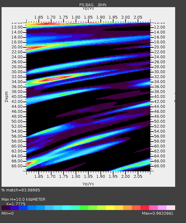
| Estimated Moho Depth: |
10.0 km |
| Estimated Crust Vp/Vs: |
1.78 |
| Assumed Crust Vp: |
6.468 km/s |
| Estimated Crust Vs: |
3.639 km/s |
| Estimated Crust Poisson's Ratio: |
0.27 |
|
| Radial Match: |
83.86965 % |
| Radial Bump: |
400 |
| Transverse Match: |
75.491325 % |
| Transverse Bump: |
400 |
| SOD ConfigId: |
4480 |
| Insert Time: |
2010-02-27 02:55:10.410 +0000 |
| GWidth: |
2.5 |
| Max Bumps: |
400 |
| Tol: |
0.001 |
|
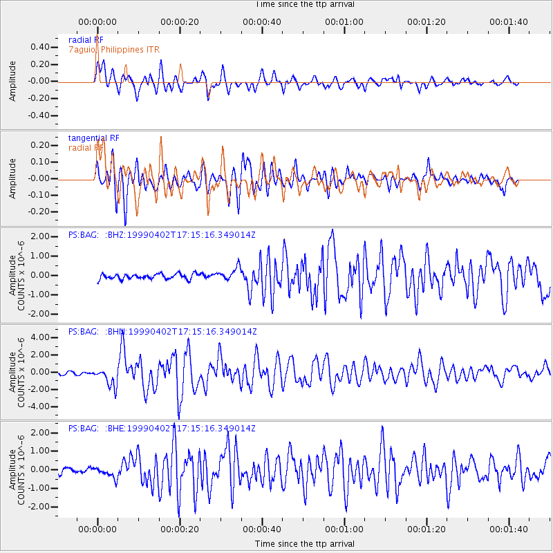
Signal To Noise
| Channel | StoN | STA | LTA |
| PS:BAG: :BHN:19990402T17:15:16.349014Z | 8.28602 | 1.1211771E-6 | 1.3530948E-7 |
| PS:BAG: :BHE:19990402T17:15:16.349014Z | 2.2320123 | 2.9950002E-7 | 1.3418385E-7 |
| PS:BAG: :BHZ:19990402T17:15:16.349014Z | 2.5692542 | 3.4428055E-7 | 1.3400019E-7 |
| Arrivals |
| Ps | 1.3 SECOND |
| PpPs | 4.1 SECOND |
| PsPs/PpSs | 5.4 SECOND |


