You are here: Home > Network List > PS - Pacific21 Stations List
> Station BAG 7aguio, Philippines > Earthquake Result Viewer
BAG 7aguio, Philippines - Earthquake Result Viewer
| Earthquake location: |
Fiji Islands Region |
| Earthquake latitude/longitude: |
-21.0/-179.1 |
| Earthquake time(UTC): |
2001/09/12 (255) 08:48:37 GMT |
| Earthquake Depth: |
608 km |
| Earthquake Magnitude: |
5.7 MB, 6.5 MW, 6.4 MW |
| Earthquake Catalog/Contributor: |
WHDF/NEIC |
|
| Network: |
PS Pacific21 |
| Station: |
BAG 7aguio, Philippines |
| Lat/Lon: |
16.41 N/120.58 E |
| Elevation: |
1507 m |
|
| Distance: |
69.9 deg |
| Az: |
297.372 deg |
| Baz: |
120.164 deg |
| Ray Param: |
0.05322756 |
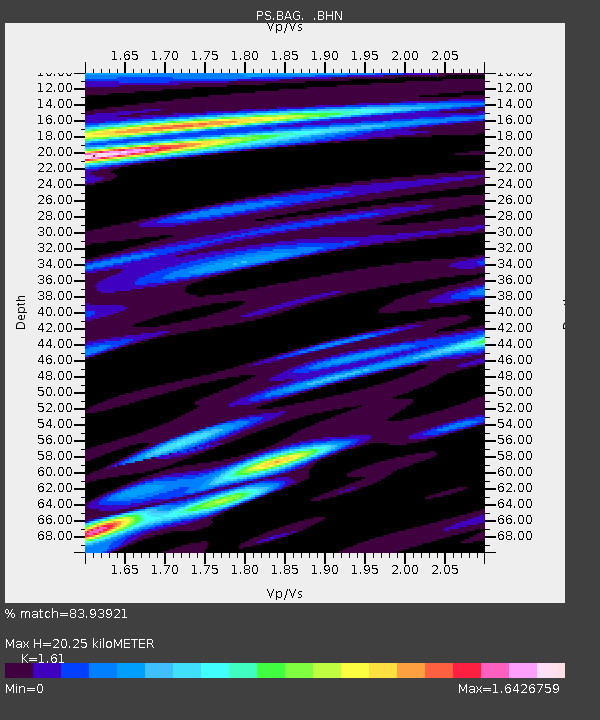
| Estimated Moho Depth: |
20.25 km |
| Estimated Crust Vp/Vs: |
1.61 |
| Assumed Crust Vp: |
6.468 km/s |
| Estimated Crust Vs: |
4.017 km/s |
| Estimated Crust Poisson's Ratio: |
0.19 |
|
| Radial Match: |
83.93921 % |
| Radial Bump: |
400 |
| Transverse Match: |
71.620995 % |
| Transverse Bump: |
400 |
| SOD ConfigId: |
20082 |
| Insert Time: |
2010-02-27 02:55:18.301 +0000 |
| GWidth: |
2.5 |
| Max Bumps: |
400 |
| Tol: |
0.001 |
|
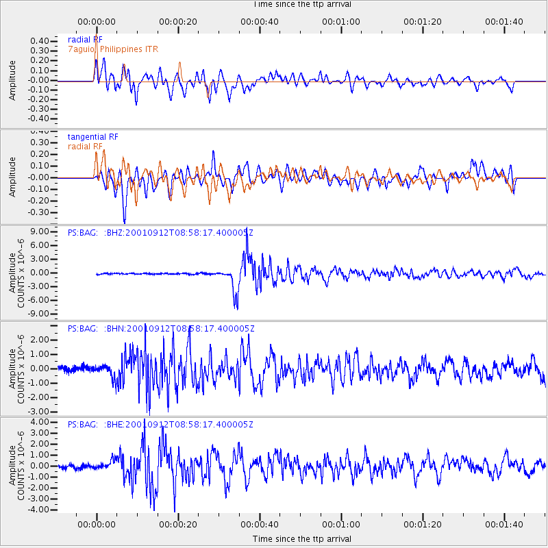
Signal To Noise
| Channel | StoN | STA | LTA |
| PS:BAG: :BHN:20010912T08:58:17.400005Z | 1.7350141 | 4.5550385E-7 | 2.625361E-7 |
| PS:BAG: :BHE:20010912T08:58:17.400005Z | 2.737939 | 4.7384148E-7 | 1.7306503E-7 |
| PS:BAG: :BHZ:20010912T08:58:17.400005Z | 27.7712 | 2.9132211E-6 | 1.049008E-7 |
| Arrivals |
| Ps | 2.0 SECOND |
| PpPs | 7.9 SECOND |
| PsPs/PpSs | 9.8 SECOND |


