You are here: Home > Network List > PS - Pacific21 Stations List
> Station BAG 7aguio, Philippines > Earthquake Result Viewer
BAG 7aguio, Philippines - Earthquake Result Viewer
| Earthquake location: |
Solomon Islands |
| Earthquake latitude/longitude: |
-7.4/155.9 |
| Earthquake time(UTC): |
2001/04/19 (109) 21:43:42 GMT |
| Earthquake Depth: |
17 km |
| Earthquake Magnitude: |
6.0 MB, 6.6 MS, 6.7 MW, 6.2 ME |
| Earthquake Catalog/Contributor: |
WHDF/NEIC |
|
| Network: |
PS Pacific21 |
| Station: |
BAG 7aguio, Philippines |
| Lat/Lon: |
16.41 N/120.58 E |
| Elevation: |
1507 m |
|
| Distance: |
42.2 deg |
| Az: |
304.346 deg |
| Baz: |
121.442 deg |
| Ray Param: |
0.07330491 |
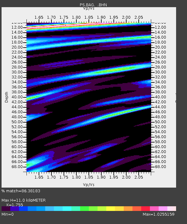
| Estimated Moho Depth: |
11.0 km |
| Estimated Crust Vp/Vs: |
1.75 |
| Assumed Crust Vp: |
6.468 km/s |
| Estimated Crust Vs: |
3.685 km/s |
| Estimated Crust Poisson's Ratio: |
0.26 |
|
| Radial Match: |
86.38183 % |
| Radial Bump: |
367 |
| Transverse Match: |
81.32965 % |
| Transverse Bump: |
400 |
| SOD ConfigId: |
4714 |
| Insert Time: |
2010-02-27 02:55:40.326 +0000 |
| GWidth: |
2.5 |
| Max Bumps: |
400 |
| Tol: |
0.001 |
|
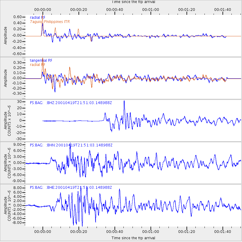
Signal To Noise
| Channel | StoN | STA | LTA |
| PS:BAG: :BHN:20010419T21:51:03.148988Z | 3.9998043 | 8.1647204E-7 | 2.04128E-7 |
| PS:BAG: :BHE:20010419T21:51:03.148988Z | 2.6630764 | 6.205572E-7 | 2.3302269E-7 |
| PS:BAG: :BHZ:20010419T21:51:03.148988Z | 16.915094 | 3.829737E-6 | 2.2640943E-7 |
| Arrivals |
| Ps | 1.4 SECOND |
| PpPs | 4.4 SECOND |
| PsPs/PpSs | 5.7 SECOND |


