You are here: Home > Network List > PS - Pacific21 Stations List
> Station BAG 7aguio, Philippines > Earthquake Result Viewer
BAG 7aguio, Philippines - Earthquake Result Viewer
| Earthquake location: |
Fiji Islands Region |
| Earthquake latitude/longitude: |
-18.1/-176.9 |
| Earthquake time(UTC): |
2001/04/28 (118) 04:49:53 GMT |
| Earthquake Depth: |
352 km |
| Earthquake Magnitude: |
6.2 MB, 6.8 MW, 6.8 MW |
| Earthquake Catalog/Contributor: |
WHDF/NEIC |
|
| Network: |
PS Pacific21 |
| Station: |
BAG 7aguio, Philippines |
| Lat/Lon: |
16.41 N/120.58 E |
| Elevation: |
1507 m |
|
| Distance: |
70.4 deg |
| Az: |
295.378 deg |
| Baz: |
116.421 deg |
| Ray Param: |
0.05393486 |
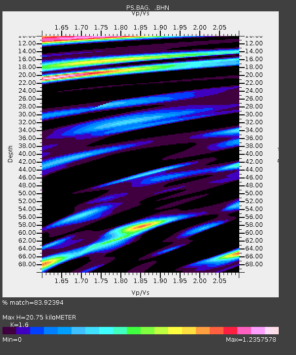
| Estimated Moho Depth: |
20.75 km |
| Estimated Crust Vp/Vs: |
1.60 |
| Assumed Crust Vp: |
6.468 km/s |
| Estimated Crust Vs: |
4.042 km/s |
| Estimated Crust Poisson's Ratio: |
0.18 |
|
| Radial Match: |
83.92394 % |
| Radial Bump: |
400 |
| Transverse Match: |
76.319046 % |
| Transverse Bump: |
400 |
| SOD ConfigId: |
4714 |
| Insert Time: |
2010-02-27 02:55:43.227 +0000 |
| GWidth: |
2.5 |
| Max Bumps: |
400 |
| Tol: |
0.001 |
|

Signal To Noise
| Channel | StoN | STA | LTA |
| PS:BAG: :BHN:20010428T04:59:59.349006Z | 1.1065714 | 1.6737621E-7 | 1.5125659E-7 |
| PS:BAG: :BHE:20010428T04:59:59.349006Z | 1.4525634 | 2.009305E-7 | 1.383282E-7 |
| PS:BAG: :BHZ:20010428T04:59:59.349006Z | 7.900891 | 7.969854E-7 | 1.0087285E-7 |
| Arrivals |
| Ps | 2.0 SECOND |
| PpPs | 8.0 SECOND |
| PsPs/PpSs | 10 SECOND |


