You are here: Home > Network List > PS - Pacific21 Stations List
> Station BAG 7aguio, Philippines > Earthquake Result Viewer
BAG 7aguio, Philippines - Earthquake Result Viewer
| Earthquake location: |
Solomon Islands |
| Earthquake latitude/longitude: |
-10.3/161.2 |
| Earthquake time(UTC): |
2001/05/09 (129) 17:38:26 GMT |
| Earthquake Depth: |
68 km |
| Earthquake Magnitude: |
6.0 MB, 5.9 MS, 6.3 MW, 6.2 MW |
| Earthquake Catalog/Contributor: |
WHDF/NEIC |
|
| Network: |
PS Pacific21 |
| Station: |
BAG 7aguio, Philippines |
| Lat/Lon: |
16.41 N/120.58 E |
| Elevation: |
1507 m |
|
| Distance: |
48.2 deg |
| Az: |
302.989 deg |
| Baz: |
120.685 deg |
| Ray Param: |
0.06931536 |
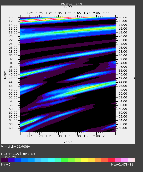
| Estimated Moho Depth: |
11.0 km |
| Estimated Crust Vp/Vs: |
1.73 |
| Assumed Crust Vp: |
6.468 km/s |
| Estimated Crust Vs: |
3.739 km/s |
| Estimated Crust Poisson's Ratio: |
0.25 |
|
| Radial Match: |
92.90594 % |
| Radial Bump: |
400 |
| Transverse Match: |
89.620605 % |
| Transverse Bump: |
400 |
| SOD ConfigId: |
4714 |
| Insert Time: |
2010-02-27 02:55:45.639 +0000 |
| GWidth: |
2.5 |
| Max Bumps: |
400 |
| Tol: |
0.001 |
|
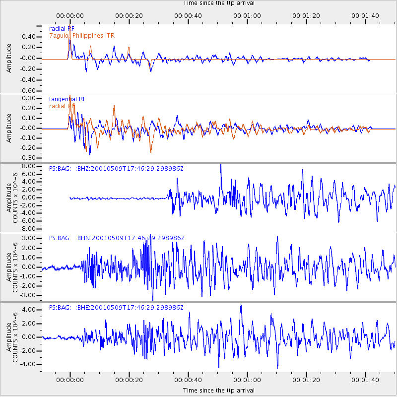
Signal To Noise
| Channel | StoN | STA | LTA |
| PS:BAG: :BHN:20010509T17:46:29.298986Z | 2.2551727 | 2.4048703E-7 | 1.0663796E-7 |
| PS:BAG: :BHE:20010509T17:46:29.298986Z | 2.620015 | 3.2886268E-7 | 1.2551939E-7 |
| PS:BAG: :BHZ:20010509T17:46:29.298986Z | 7.676029 | 9.295707E-7 | 1.2110047E-7 |
| Arrivals |
| Ps | 1.3 SECOND |
| PpPs | 4.4 SECOND |
| PsPs/PpSs | 5.7 SECOND |


