You are here: Home > Network List > PS - Pacific21 Stations List
> Station BAG 7aguio, Philippines > Earthquake Result Viewer
BAG 7aguio, Philippines - Earthquake Result Viewer

| Earthquake location: |
Kuril Islands |
| Earthquake latitude/longitude: |
44.3/148.4 |
| Earthquake time(UTC): |
2001/05/25 (145) 00:40:50 GMT |
| Earthquake Depth: |
33 km |
| Earthquake Magnitude: |
6.1 MB, 6.7 MS, 6.7 MW, 6.6 MW |
| Earthquake Catalog/Contributor: |
WHDF/NEIC |
|
| Network: |
PS Pacific21 |
| Station: |
BAG 7aguio, Philippines |
| Lat/Lon: |
16.41 N/120.58 E |
| Elevation: |
1507 m |
|
| Distance: |
36.4 deg |
| Az: |
229.037 deg |
| Baz: |
34.419 deg |
| Ray Param: |
0.07665476 |
| Estimated Moho Depth: |
45.5 km |
| Estimated Crust Vp/Vs: |
2.10 |
| Assumed Crust Vp: |
6.468 km/s |
| Estimated Crust Vs: |
3.087 km/s |
| Estimated Crust Poisson's Ratio: |
0.35 |
|
| Radial Match: |
85.40501 % |
| Radial Bump: |
400 |
| Transverse Match: |
79.42835 % |
| Transverse Bump: |
400 |
| SOD ConfigId: |
4714 |
| Insert Time: |
2010-02-27 02:55:48.604 +0000 |
| GWidth: |
2.5 |
| Max Bumps: |
400 |
| Tol: |
0.001 |
|
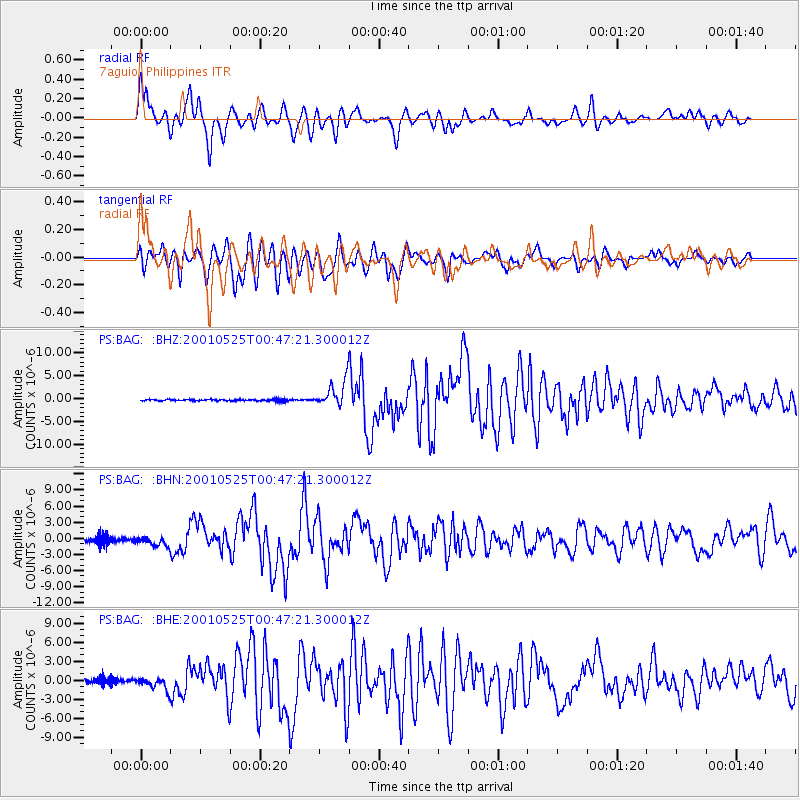
Signal To Noise
| Channel | StoN | STA | LTA |
| PS:BAG: :BHN:20010525T00:47:21.300012Z | 1.9480269 | 8.8426395E-7 | 4.53928E-7 |
| PS:BAG: :BHE:20010525T00:47:21.300012Z | 3.1458118 | 1.0047481E-6 | 3.1939234E-7 |
| PS:BAG: :BHZ:20010525T00:47:21.300012Z | 17.246187 | 2.8142827E-6 | 1.6318289E-7 |
| Arrivals |
| Ps | 8.2 SECOND |
| PpPs | 20 SECOND |
| PsPs/PpSs | 29 SECOND |


