You are here: Home > Network List > PS - Pacific21 Stations List
> Station BAG 7aguio, Philippines > Earthquake Result Viewer
BAG 7aguio, Philippines - Earthquake Result Viewer
| Earthquake location: |
Solomon Islands |
| Earthquake latitude/longitude: |
-7.9/158.6 |
| Earthquake time(UTC): |
1998/11/25 (329) 18:05:25 GMT |
| Earthquake Depth: |
48 km |
| Earthquake Magnitude: |
5.9 MB, 6.0 MS, 6.2 UNKNOWN, 6.2 MW |
| Earthquake Catalog/Contributor: |
WHDF/NEIC |
|
| Network: |
PS Pacific21 |
| Station: |
BAG 7aguio, Philippines |
| Lat/Lon: |
16.41 N/120.58 E |
| Elevation: |
1507 m |
|
| Distance: |
44.7 deg |
| Az: |
302.779 deg |
| Baz: |
119.786 deg |
| Ray Param: |
0.07163063 |
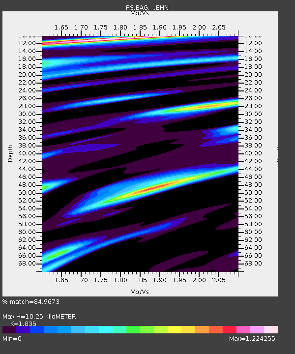
| Estimated Moho Depth: |
10.25 km |
| Estimated Crust Vp/Vs: |
1.84 |
| Assumed Crust Vp: |
6.468 km/s |
| Estimated Crust Vs: |
3.525 km/s |
| Estimated Crust Poisson's Ratio: |
0.29 |
|
| Radial Match: |
84.9673 % |
| Radial Bump: |
400 |
| Transverse Match: |
84.51887 % |
| Transverse Bump: |
400 |
| SOD ConfigId: |
4480 |
| Insert Time: |
2010-02-27 02:56:16.755 +0000 |
| GWidth: |
2.5 |
| Max Bumps: |
400 |
| Tol: |
0.001 |
|

Signal To Noise
| Channel | StoN | STA | LTA |
| PS:BAG: :BHN:19981125T18:13:03.598987Z | 8.464737 | 4.957262E-6 | 5.856368E-7 |
| PS:BAG: :BHE:19981125T18:13:03.598987Z | 2.2914233 | 1.0765525E-6 | 4.6981825E-7 |
| PS:BAG: :BHZ:19981125T18:13:03.598987Z | 2.295638 | 1.1956795E-6 | 5.208484E-7 |
| Arrivals |
| Ps | 1.4 SECOND |
| PpPs | 4.2 SECOND |
| PsPs/PpSs | 5.6 SECOND |


