You are here: Home > Network List > PS - Pacific21 Stations List
> Station BAG 7aguio, Philippines > Earthquake Result Viewer
BAG 7aguio, Philippines - Earthquake Result Viewer
*The percent match for this event was below the threshold and hence no stack was calculated.
| Earthquake location: |
Rat Islands, Aleutian Islands |
| Earthquake latitude/longitude: |
51.6/175.2 |
| Earthquake time(UTC): |
1998/08/20 (232) 15:00:08 GMT |
| Earthquake Depth: |
33 km |
| Earthquake Magnitude: |
5.6 MB, 6.0 MS, 6.2 UNKNOWN, 6.2 MW |
| Earthquake Catalog/Contributor: |
WHDF/NEIC |
|
| Network: |
PS Pacific21 |
| Station: |
BAG 7aguio, Philippines |
| Lat/Lon: |
16.41 N/120.58 E |
| Elevation: |
1507 m |
|
| Distance: |
55.6 deg |
| Az: |
251.703 deg |
| Baz: |
38.079 deg |
| Ray Param: |
$rayparam |
*The percent match for this event was below the threshold and hence was not used in the summary stack. |
|
| Radial Match: |
80.76607 % |
| Radial Bump: |
400 |
| Transverse Match: |
84.061584 % |
| Transverse Bump: |
400 |
| SOD ConfigId: |
4480 |
| Insert Time: |
2010-02-27 02:56:27.983 +0000 |
| GWidth: |
2.5 |
| Max Bumps: |
400 |
| Tol: |
0.001 |
|
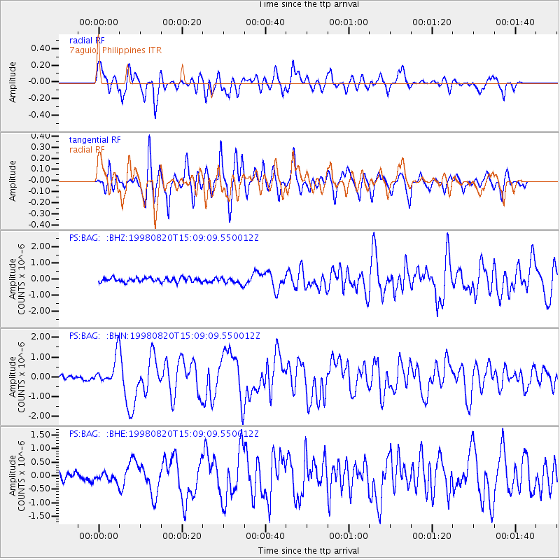
Signal To Noise
| Channel | StoN | STA | LTA |
| PS:BAG: :BHN:19980820T15:09:09.550012Z | 7.579221 | 7.6443285E-7 | 1.00859026E-7 |
| PS:BAG: :BHE:19980820T15:09:09.550012Z | 1.1184783 | 1.6082535E-7 | 1.4378942E-7 |
| PS:BAG: :BHZ:19980820T15:09:09.550012Z | 1.6234934 | 2.1136694E-7 | 1.3019266E-7 |
| Arrivals |
| Ps | |
| PpPs | |
| PsPs/PpSs | |


