You are here: Home > Network List > TA - USArray Transportable Network (new EarthScope stations) Stations List
> Station 457A Yulee, FL, USA > Earthquake Result Viewer
457A Yulee, FL, USA - Earthquake Result Viewer
| Earthquake location: |
Kuril Islands |
| Earthquake latitude/longitude: |
46.2/150.8 |
| Earthquake time(UTC): |
2013/04/19 (109) 03:05:52 GMT |
| Earthquake Depth: |
110 km |
| Earthquake Magnitude: |
7.2 MW, 7.1 MB, 7.2 MW |
| Earthquake Catalog/Contributor: |
NEIC PDE/NEIC PDE-W |
|
| Network: |
TA USArray Transportable Network (new EarthScope stations) |
| Station: |
457A Yulee, FL, USA |
| Lat/Lon: |
30.62 N/81.56 W |
| Elevation: |
16 m |
|
| Distance: |
90.1 deg |
| Az: |
43.038 deg |
| Baz: |
326.655 deg |
| Ray Param: |
0.041679036 |
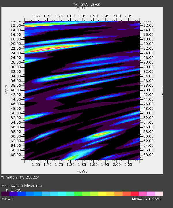
| Estimated Moho Depth: |
22.0 km |
| Estimated Crust Vp/Vs: |
1.71 |
| Assumed Crust Vp: |
5.989 km/s |
| Estimated Crust Vs: |
3.513 km/s |
| Estimated Crust Poisson's Ratio: |
0.24 |
|
| Radial Match: |
95.258224 % |
| Radial Bump: |
400 |
| Transverse Match: |
90.44618 % |
| Transverse Bump: |
400 |
| SOD ConfigId: |
512894 |
| Insert Time: |
2013-09-13 11:33:52.685 +0000 |
| GWidth: |
2.5 |
| Max Bumps: |
400 |
| Tol: |
0.001 |
|
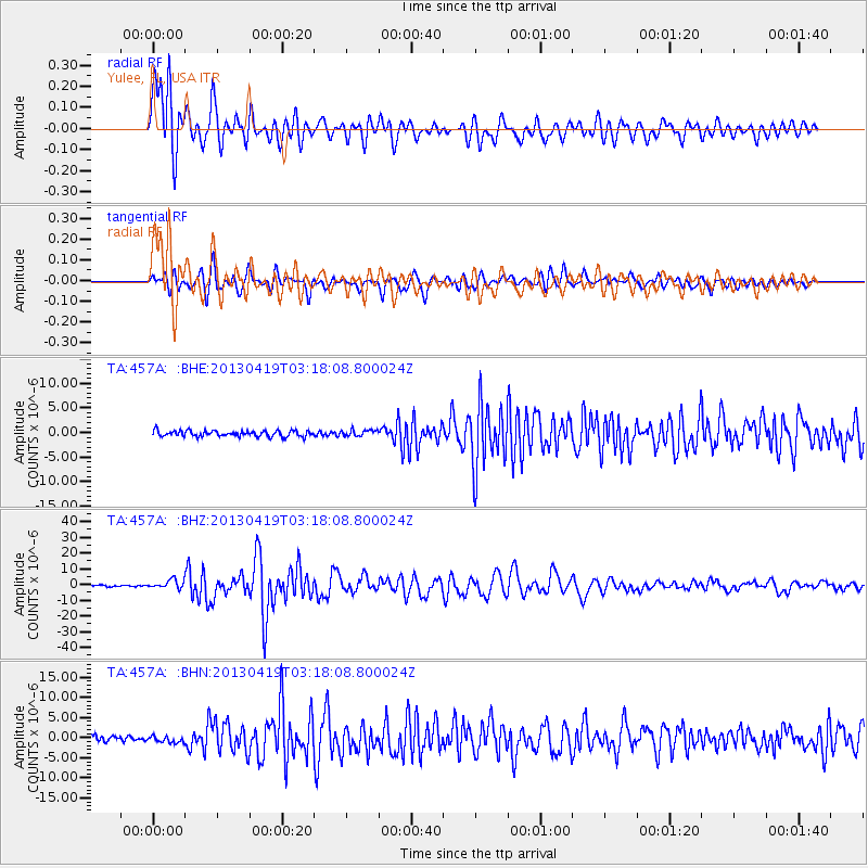
Signal To Noise
| Channel | StoN | STA | LTA |
| TA:457A: :BHZ:20130419T03:18:08.800024Z | 6.5317955 | 2.7665697E-6 | 4.235542E-7 |
| TA:457A: :BHN:20130419T03:18:08.800024Z | 1.3125927 | 8.163134E-7 | 6.219091E-7 |
| TA:457A: :BHE:20130419T03:18:08.800024Z | 1.0874776 | 6.4090204E-7 | 5.893474E-7 |
| Arrivals |
| Ps | 2.6 SECOND |
| PpPs | 9.8 SECOND |
| PsPs/PpSs | 12 SECOND |


