You are here: Home > Network List > TA - USArray Transportable Network (new EarthScope stations) Stations List
> Station 658A Bunnell, FL, USA > Earthquake Result Viewer
658A Bunnell, FL, USA - Earthquake Result Viewer

| Earthquake location: |
Kuril Islands |
| Earthquake latitude/longitude: |
46.2/150.8 |
| Earthquake time(UTC): |
2013/04/19 (109) 03:05:52 GMT |
| Earthquake Depth: |
110 km |
| Earthquake Magnitude: |
7.2 MW, 7.1 MB, 7.2 MW |
| Earthquake Catalog/Contributor: |
NEIC PDE/NEIC PDE-W |
|
| Network: |
TA USArray Transportable Network (new EarthScope stations) |
| Station: |
658A Bunnell, FL, USA |
| Lat/Lon: |
29.42 N/81.26 W |
| Elevation: |
11 m |
|
| Distance: |
91.2 deg |
| Az: |
43.477 deg |
| Baz: |
326.799 deg |
| Ray Param: |
0.04159776 |
| Estimated Moho Depth: |
35.25 km |
| Estimated Crust Vp/Vs: |
1.79 |
| Assumed Crust Vp: |
6.134 km/s |
| Estimated Crust Vs: |
3.422 km/s |
| Estimated Crust Poisson's Ratio: |
0.27 |
|
| Radial Match: |
94.29118 % |
| Radial Bump: |
400 |
| Transverse Match: |
86.39496 % |
| Transverse Bump: |
400 |
| SOD ConfigId: |
512894 |
| Insert Time: |
2013-09-13 11:34:24.963 +0000 |
| GWidth: |
2.5 |
| Max Bumps: |
400 |
| Tol: |
0.001 |
|
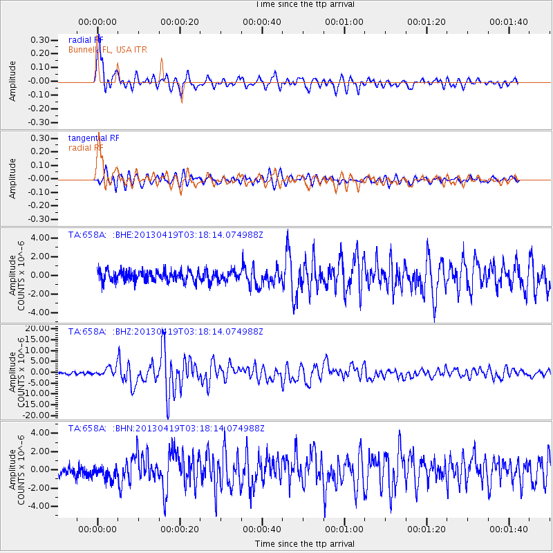
Signal To Noise
| Channel | StoN | STA | LTA |
| TA:658A: :BHZ:20130419T03:18:14.074988Z | 6.1119647 | 2.1810395E-6 | 3.5684755E-7 |
| TA:658A: :BHN:20130419T03:18:14.074988Z | 1.553753 | 7.73217E-7 | 4.9764475E-7 |
| TA:658A: :BHE:20130419T03:18:14.074988Z | 0.86855054 | 4.9275394E-7 | 5.6732904E-7 |
| Arrivals |
| Ps | 4.6 SECOND |
| PpPs | 16 SECOND |
| PsPs/PpSs | 20 SECOND |


