You are here: Home > Network List > TA - USArray Transportable Network (new EarthScope stations) Stations List
> Station 758A Lake Helen, FL, USA > Earthquake Result Viewer
758A Lake Helen, FL, USA - Earthquake Result Viewer

| Earthquake location: |
Kuril Islands |
| Earthquake latitude/longitude: |
46.2/150.8 |
| Earthquake time(UTC): |
2013/04/19 (109) 03:05:52 GMT |
| Earthquake Depth: |
110 km |
| Earthquake Magnitude: |
7.2 MW, 7.1 MB, 7.2 MW |
| Earthquake Catalog/Contributor: |
NEIC PDE/NEIC PDE-W |
|
| Network: |
TA USArray Transportable Network (new EarthScope stations) |
| Station: |
758A Lake Helen, FL, USA |
| Lat/Lon: |
28.96 N/81.20 W |
| Elevation: |
16 m |
|
| Distance: |
91.6 deg |
| Az: |
43.685 deg |
| Baz: |
326.822 deg |
| Ray Param: |
0.041538354 |
| Estimated Moho Depth: |
28.75 km |
| Estimated Crust Vp/Vs: |
2.09 |
| Assumed Crust Vp: |
6.134 km/s |
| Estimated Crust Vs: |
2.935 km/s |
| Estimated Crust Poisson's Ratio: |
0.35 |
|
| Radial Match: |
93.45092 % |
| Radial Bump: |
400 |
| Transverse Match: |
90.53394 % |
| Transverse Bump: |
400 |
| SOD ConfigId: |
512894 |
| Insert Time: |
2013-09-13 11:34:33.925 +0000 |
| GWidth: |
2.5 |
| Max Bumps: |
400 |
| Tol: |
0.001 |
|
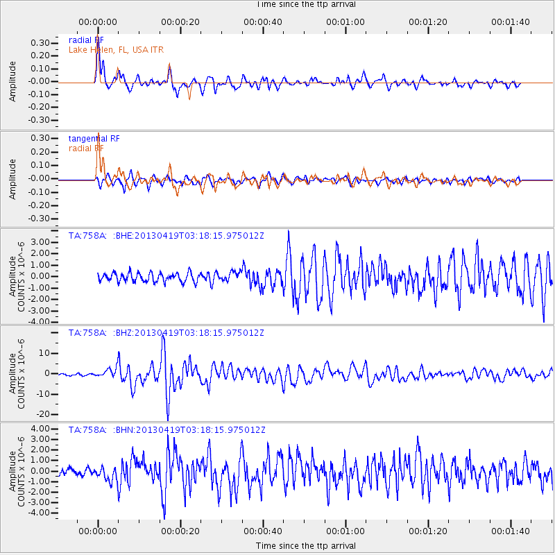
Signal To Noise
| Channel | StoN | STA | LTA |
| TA:758A: :BHZ:20130419T03:18:15.975012Z | 6.034903 | 2.3553998E-6 | 3.902962E-7 |
| TA:758A: :BHN:20130419T03:18:15.975012Z | 1.9430437 | 6.5800083E-7 | 3.3864438E-7 |
| TA:758A: :BHE:20130419T03:18:15.975012Z | 1.074574 | 4.018207E-7 | 3.7393485E-7 |
| Arrivals |
| Ps | 5.2 SECOND |
| PpPs | 14 SECOND |
| PsPs/PpSs | 19 SECOND |


