You are here: Home > Network List > TA - USArray Transportable Network (new EarthScope stations) Stations List
> Station 858A St. Cloud, FL, USA > Earthquake Result Viewer
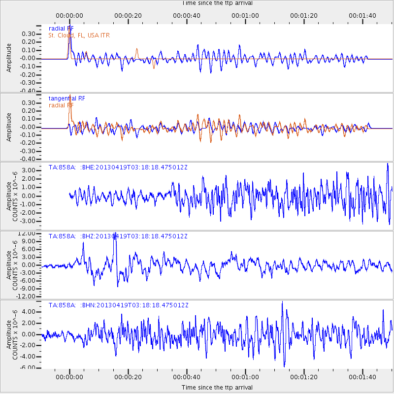
858A St. Cloud, FL, USA - Earthquake Result Viewer
*The percent match for this event was below the threshold and hence no stack was calculated.
| Earthquake location: |
Kuril Islands |
| Earthquake latitude/longitude: |
46.2/150.8 |
| Earthquake time(UTC): |
2013/04/19 (109) 03:05:52 GMT |
| Earthquake Depth: |
110 km |
| Earthquake Magnitude: |
7.2 MW, 7.1 MB, 7.2 MW |
| Earthquake Catalog/Contributor: |
NEIC PDE/NEIC PDE-W |
|
| Network: |
TA USArray Transportable Network (new EarthScope stations) |
| Station: |
858A St. Cloud, FL, USA |
| Lat/Lon: |
28.21 N/81.36 W |
| Elevation: |
27 m |
|
| Distance: |
92.1 deg |
| Az: |
44.214 deg |
| Baz: |
326.728 deg |
| Ray Param: |
$rayparam |
*The percent match for this event was below the threshold and hence was not used in the summary stack. |
|
| Radial Match: |
79.738014 % |
| Radial Bump: |
400 |
| Transverse Match: |
70.192444 % |
| Transverse Bump: |
400 |
| SOD ConfigId: |
512894 |
| Insert Time: |
2013-09-13 11:34:40.800 +0000 |
| GWidth: |
2.5 |
| Max Bumps: |
400 |
| Tol: |
0.001 |
|
Signal To Noise
| Channel | StoN | STA | LTA |
| TA:858A: :BHZ:20130419T03:18:18.475012Z | 6.634588 | 2.5961135E-6 | 3.912999E-7 |
| TA:858A: :BHN:20130419T03:18:18.475012Z | 1.3445171 | 6.461944E-7 | 4.8061446E-7 |
| TA:858A: :BHE:20130419T03:18:18.475012Z | 0.7509043 | 4.072818E-7 | 5.423884E-7 |
| Arrivals |
| Ps | |
| PpPs | |
| PsPs/PpSs | |


