You are here: Home > Network List > PS - Pacific21 Stations List
> Station MCSJ Minamitorishima, Marcus Island, Japan > Earthquake Result Viewer
MCSJ Minamitorishima, Marcus Island, Japan - Earthquake Result Viewer
| Earthquake location: |
Vancouver Island, Canada Region |
| Earthquake latitude/longitude: |
48.9/-129.3 |
| Earthquake time(UTC): |
2001/01/11 (011) 00:04:03 GMT |
| Earthquake Depth: |
10 km |
| Earthquake Magnitude: |
5.4 MB, 5.8 MS, 6.1 MW, 6.0 MW |
| Earthquake Catalog/Contributor: |
WHDF/NEIC |
|
| Network: |
PS Pacific21 |
| Station: |
MCSJ Minamitorishima, Marcus Island, Japan |
| Lat/Lon: |
24.29 N/153.98 E |
| Elevation: |
10 m |
|
| Distance: |
63.5 deg |
| Az: |
277.215 deg |
| Baz: |
45.854 deg |
| Ray Param: |
0.05951785 |
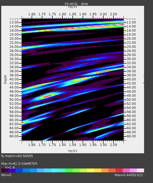
| Estimated Moho Depth: |
61.0 km |
| Estimated Crust Vp/Vs: |
1.60 |
| Assumed Crust Vp: |
4.24 km/s |
| Estimated Crust Vs: |
2.65 km/s |
| Estimated Crust Poisson's Ratio: |
0.18 |
|
| Radial Match: |
80.58555 % |
| Radial Bump: |
171 |
| Transverse Match: |
56.807972 % |
| Transverse Bump: |
400 |
| SOD ConfigId: |
3744 |
| Insert Time: |
2010-02-27 02:57:42.739 +0000 |
| GWidth: |
2.5 |
| Max Bumps: |
400 |
| Tol: |
0.001 |
|
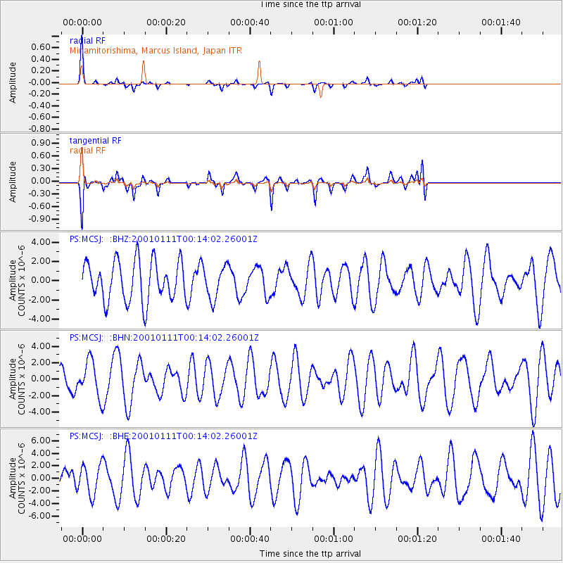
Signal To Noise
| Channel | StoN | STA | LTA |
| PS:MCSJ: :BHN:20010111T00:14:02.26001Z | 1.2573125 | 2.2079478E-6 | 1.756085E-6 |
| PS:MCSJ: :BHE:20010111T00:14:02.26001Z | 0.8830459 | 2.3888006E-6 | 2.7051826E-6 |
| PS:MCSJ: :BHZ:20010111T00:14:02.26001Z | 0.81253844 | 1.6714259E-6 | 2.0570421E-6 |
| Arrivals |
| Ps | 8.8 SECOND |
| PpPs | 37 SECOND |
| PsPs/PpSs | 45 SECOND |


