
Station PS MCSJ - Minamitorishima, Marcus Island, Japan
Network: PS - Pacific21
Nearby stations (2 deg radius)
| Station | Name | (Lat, Lon) | Start / End | Elevation |
| MCSJ | Minamitorishima, Marcus Island, Japan | (24.29, 153.98) | 1996-09-01 / 2499-01-01 | 10 m |
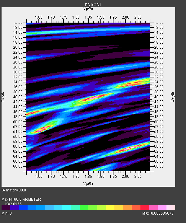
| Crust2 Type: | A0,normal oceanic, 0.07 km seds. |
| Thickness Estimate: | 60 km |
| Thickness StdDev: | 11 km |
| Vp/Vs Estimate: | 2.02 |
| Vp/Vs StdDev: | 0.16 |
| Vs Estimate: | 2.102 km/s |
| Poisson's Ratio: | 0.34 |
| Peak Value: | 0.01 |
| Assumed Vp: | 4.24 km/s |
| Ps Weight: | 0.33333334 |
| PpPs Weight: | 0.33333334 |
| PsPs Weight: | 0.33333328 |
| Residual Complexity: | 0.925 |
| Nearby stations H: | +- |
| (2.0 deg) Vp/Vs: | +- |
7 with match > 90% ( 18.918919 %) and 8 with match > 80% ( 21.621622 %) out of 37.
Download stack as xyz text file.
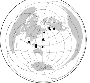
Azimuth Distribution of Events:
Prior Results for this Station
| Study | Thickness | Vp/Vs | Vp | Vs | Poissons Ratio | Extra |
| EARS | 60 km | 2.02 | 4.24 km/s | 2.102 km/s | 0.34 | |
| Crust2.0 | 12 km | 2.19 | 4.24 km/s | 1.94 km/s | 0.37 | A0,normal oceanic, 0.07 km seds. |
| Global Maxima | 60 km | 2.02 | 4.24 km/s | 2.102 km/s | 0.34 | amp=0.006585073 |
| Local Maxima 1 | 40 km | 1.88 | 4.24 km/s | 2.261 km/s | 0.30 | amp=0.0061675212 |
| Local Maxima 2 | 54 km | 1.65 | 4.24 km/s | 2.566 km/s | 0.21 | amp=0.0058562495 |
| Local Maxima 3 | 46 km | 1.62 | 4.24 km/s | 2.625 km/s | 0.19 | amp=0.0055655846 |
| Local Maxima 4 | 35 km | 2.02 | 4.24 km/s | 2.099 km/s | 0.34 | amp=0.0052334657 |
| Predicted Arrivals for vertical incidence (zero ray parameter) | |
| Ps | 14.52 SECOND |
| PpPs | 43.06 SECOND |
| PsPs/PpSs | 57.58 SECOND |
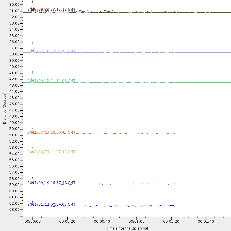
Events Processed for this Station
Download zip of receiver functions as SAC
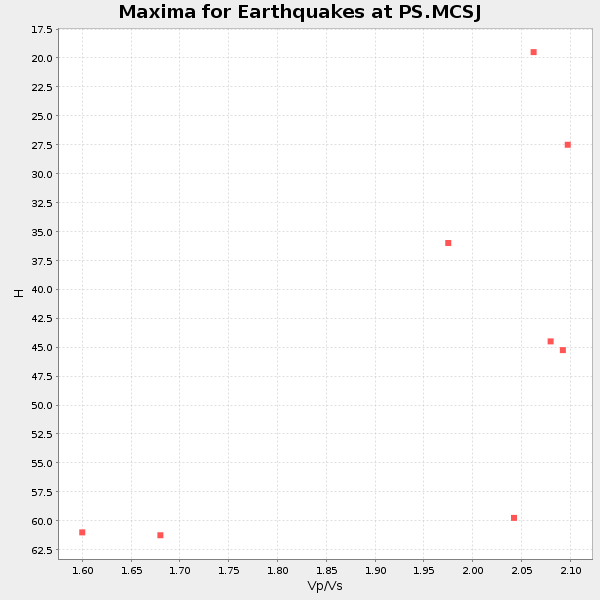
Plot maxima for each earthquake.
Events Used in the Stack
(8 events)| Radial Match | Distance | Baz | FERegion | Time | Lat/Lon | Depth | Magnitude |
| 99.734856 | 54.4 deg | 27.909 deg | Central Alaska | 2002/10/23 11:27:19 GMT | (63.5, -147.9) | 4.2 km | 6.0 MB, 6.7 MS, 6.7 MW, 6.7 MW |
| 99.1408 | 37.0 deg | 233.192 deg | Southern Molucca Sea | 2005/07/18 19:37:19 GMT | (-0.2, 125.1) | 19 km | 5.8 MB, 5.1 MS, 5.9 MW, 5.8 MW |
| 99.064415 | 51.1 deg | 34.949 deg | Kodiak Island Region, Alaska | 2001/07/19 18:00:40 GMT | (57.2, -151.0) | 33 km | 5.9 MB, 5.4 MS, 5.9 MW, 5.9 ML |
| 97.616554 | 42.2 deg | 224.716 deg | Banda Sea | 2005/09/12 21:51:06 GMT | (-7.7, 125.5) | 30 km | 5.5 MB, 4.5 MS |
| 97.20451 | 29.9 deg | 184.591 deg | New Britain Region, P.N.G. | 2005/09/30 23:15:19 GMT | (-5.7, 151.7) | 25 km | 5.5 MB, 5.7 MS, 5.9 MW, 5.9 MW |
| 91.488655 | 59.8 deg | 261.11 deg | Northern Sumatra, Indonesia | 2005/09/10 16:57:47 GMT | (4.9, 95.0) | 41 km | 5.8 MB, 5.5 MS, 5.8 MW, 5.8 MW |
| 91.00062 | 30.1 deg | 8.937 deg | Off East Coast Of Kamchatka | 1997/12/05 11:35:19 GMT | (53.9, 161.6) | 33 km | 5.7 MB |
| 80.58555 | 63.5 deg | 45.854 deg | Vancouver Island, Canada Region | 2001/01/11 00:04:03 GMT | (48.9, -129.3) | 10 km | 5.4 MB, 5.8 MS, 6.1 MW, 6.0 MW |
Losers
(29 events)| Radial Match | Distance | Baz | FERegion | Time | Lat/Lon | Depth | Magnitude | Reason |
| 99.97961 | 30.6 deg | 210.727 deg | Irian Jaya, Indonesia | 1998/07/29 18:00:29 GMT | (-2.7, 138.9) | 33 km | 5.9 MB, 6.7 MS, 6.6 UNKNOWN, 6.2 ME | |
| 99.81048 | 30.8 deg | 211.952 deg | Irian Jaya, Indonesia | 1999/05/16 15:25:53 GMT | (-2.6, 138.2) | 59 km | 6.1 MB, 6.2 MS, 6.4 MW, 6.4 ME | |
| 98.4372 | 39.9 deg | 34.588 deg | Fox Islands, Aleutian Islands | 1999/01/28 08:10:05 GMT | (52.9, -169.1) | 67 km | 6.3 MB, 6.1 MS, 6.6 MW, 6.6 ME | |
| 91.20429 | 41.0 deg | 239.385 deg | Minahassa Peninsula, Sulawesi | 1998/05/21 05:34:25 GMT | (0.2, 119.6) | 33 km | 6.2 MB, 6.3 MS, 6.6 UNKNOWN, 6.6 MW | |
| 87.028625 | 36.3 deg | 227.854 deg | Halmahera, Indonesia | 1997/06/24 23:04:53 GMT | (-1.9, 127.9) | 33 km | 5.9 MB, 6.1 MS, 6.4 UNKNOWN, 6.1 MS | |
| 86.45544 | 30.2 deg | 192.163 deg | Eastern New Guinea Reg., P.N.G. | 1997/12/22 02:05:50 GMT | (-5.5, 147.9) | 179 km | 6.3 MB, 6.7 MS, 7.1 UNKNOWN, 7.0 ME | |
| 86.385735 | 41.3 deg | 160.191 deg | Vanuatu Islands | 1997/11/15 18:59:24 GMT | (-15.1, 167.4) | 123 km | 6.4 MB, 7.0 UNKNOWN, 6.8 ME | |
| 86.25402 | 43.5 deg | 234.738 deg | Sulawesi, Indonesia | 1997/09/28 01:38:28 GMT | (-3.8, 119.7) | 33 km | 5.6 MB, 5.5 MS, 5.9 UNKNOWN, 5.9 MW | |
| 83.71356 | 94.7 deg | 226.177 deg | Mid-Indian Ridge | 1997/08/20 13:51:16 GMT | (-41.7, 80.1) | 10 km | 5.6 MB, 6.4 MS, 6.5 UNKNOWN, 6.4 MW | |
| 83.12806 | 38.5 deg | 231.244 deg | Ceram Sea | 1998/11/29 14:10:31 GMT | (-2.1, 124.9) | 33 km | 6.5 MB, 7.7 MS, 8.1 UNKNOWN, 7.8 MW | |
| 79.21722 | 35.8 deg | 233.473 deg | Northern Molucca Sea | 1998/10/28 16:25:03 GMT | (0.8, 126.0) | 33 km | 6.2 MB, 6.2 MS, 6.6 UNKNOWN, 6.6 MW | |
| 78.16706 | 60.3 deg | 153.159 deg | Kermadec Islands, New Zealand | 1998/07/09 14:45:39 GMT | (-30.5, -179.0) | 130 km | 6.2 MB, 6.2 MS, 6.9 UNKNOWN, 6.4 ME | |
| 78.07034 | 30.1 deg | 179.049 deg | Solomon Islands | 1997/09/07 12:57:06 GMT | (-6.0, 154.5) | 421 km | 5.6 MB, 5.8 UNKNOWN, 5.8 MW | |
| 77.98377 | 49.2 deg | 145.19 deg | Fiji Islands Region | 1998/03/29 19:48:16 GMT | (-17.6, -179.1) | 537 km | 6.5 MB, 7.2 UNKNOWN, 7.1 MW | |
| 74.10502 | 58.5 deg | 253.301 deg | Southern Sumatra, Indonesia | 1998/04/01 17:56:23 GMT | (-0.5, 99.3) | 56 km | 6.2 MB, 6.9 MS, 7.0 UNKNOWN, 6.6 ME | |
| 71.74331 | 54.2 deg | 146.021 deg | South Of Fiji Islands | 1997/10/14 09:53:18 GMT | (-22.1, -176.8) | 167 km | 6.7 MB, 7.7 UNKNOWN, 7.4 ME | |
| 70.59959 | 94.9 deg | 67.137 deg | Guerrero, Mexico | 1997/05/22 07:50:53 GMT | (18.7, -101.6) | 70 km | 5.9 MB, 6.0 MS, 6.6 UNKNOWN, 6.5 MW | |
| 69.92991 | 37.1 deg | 159.902 deg | Santa Cruz Islands | 1998/07/16 11:56:36 GMT | (-11.0, 166.2) | 110 km | 6.4 MB, 6.7 MS, 7.1 UNKNOWN, 6.9 ME | |
| 68.745735 | 31.2 deg | 266.24 deg | Luzon, Philippines | 1998/05/06 01:53:09 GMT | (18.7, 120.9) | 33 km | 5.5 MB, 5.3 MS, 5.9 UNKNOWN, 5.7 MW | |
| 68.46852 | 38.2 deg | 218.684 deg | Tanimbar Islands Reg., Indonesia | 1996/12/29 03:43:28 GMT | (-6.9, 131.1) | 31 km | 5.8 MB, 5.3 MS, 5.8 UNKNOWN, 5.8 MW | |
| 66.525406 | 61.3 deg | 154.198 deg | Kermadec Islands Region | 1997/05/03 16:46:02 GMT | (-31.8, -179.4) | 108 km | 6.6 MB, 6.9 UNKNOWN, 6.8 ME | |
| 65.941315 | 49.9 deg | 144.869 deg | Fiji Islands Region | 1999/04/24 08:45:16 GMT | (-18.0, -178.4) | 568 km | 5.6 MW, 5.2 MB, 5.5 MW | |
| 65.40898 | 52.9 deg | 148.787 deg | South Of Fiji Islands | 1998/05/16 02:22:03 GMT | (-22.2, -179.5) | 586 km | 6.1 MB, 6.8 UNKNOWN | |
| 61.820312 | 91.8 deg | 241.868 deg | Mid-Indian Ridge | 1999/01/24 08:00:08 GMT | (-26.5, 74.5) | 10 km | 6.0 MB, 6.3 MS, 6.3 MW, 6.3 ME | |
| 61.570473 | 83.3 deg | 299.921 deg | Northern And Central Iran | 1998/03/14 19:40:27 GMT | (30.2, 57.6) | 9.0 km | 5.9 MB, 6.9 MS, 6.6 UNKNOWN, 6.3 ME | |
| 61.067497 | 39.6 deg | 160.844 deg | Vanuatu Islands | 1997/04/23 03:47:18 GMT | (-13.6, 166.4) | 33 km | 5.5 MB, 6.0 MS, 6.1 UNKNOWN, 5.9 MW | |
| 60.833466 | 54.8 deg | 143.255 deg | Tonga Islands | 1997/09/10 12:57:07 GMT | (-21.3, -174.4) | 10 km | 5.7 MB, 6.1 MS, 6.1 UNKNOWN, 5.9 MW | |
| 55.516327 | 30.1 deg | 241.245 deg | Philippine Islands Region | 1997/03/11 19:22:00 GMT | (7.7, 127.6) | 10 km | 6.3 MB, 6.7 MS, 6.9 UNKNOWN, 6.8 MW | |
| 33.57642 | 48.2 deg | 160.064 deg | Southeast Of Loyalty Islands | 1998/07/31 12:40:59 GMT | (-21.6, 169.8) | 33 km | 5.9 MS, 5.4 MB, 6.1 UNKNOWN, 6.0 MW |
