You are here: Home > Network List > PS - Pacific21 Stations List
> Station MCSJ Minamitorishima, Marcus Island, Japan > Earthquake Result Viewer
MCSJ Minamitorishima, Marcus Island, Japan - Earthquake Result Viewer
| Earthquake location: |
Kodiak Island Region, Alaska |
| Earthquake latitude/longitude: |
57.2/-151.0 |
| Earthquake time(UTC): |
2001/07/19 (200) 18:00:40 GMT |
| Earthquake Depth: |
33 km |
| Earthquake Magnitude: |
5.9 MB, 5.4 MS, 5.9 MW, 5.9 ML |
| Earthquake Catalog/Contributor: |
WHDF/NEIC |
|
| Network: |
PS Pacific21 |
| Station: |
MCSJ Minamitorishima, Marcus Island, Japan |
| Lat/Lon: |
24.29 N/153.98 E |
| Elevation: |
10 m |
|
| Distance: |
51.1 deg |
| Az: |
253.836 deg |
| Baz: |
34.949 deg |
| Ray Param: |
0.06757285 |
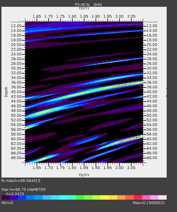
| Estimated Moho Depth: |
59.75 km |
| Estimated Crust Vp/Vs: |
2.04 |
| Assumed Crust Vp: |
4.24 km/s |
| Estimated Crust Vs: |
2.076 km/s |
| Estimated Crust Poisson's Ratio: |
0.34 |
|
| Radial Match: |
99.064415 % |
| Radial Bump: |
85 |
| Transverse Match: |
66.91852 % |
| Transverse Bump: |
400 |
| SOD ConfigId: |
3753 |
| Insert Time: |
2010-02-27 02:57:44.910 +0000 |
| GWidth: |
2.5 |
| Max Bumps: |
400 |
| Tol: |
0.001 |
|

Signal To Noise
| Channel | StoN | STA | LTA |
| PS:MCSJ: :BHN:20010719T18:09:09.058986Z | 1.8665833 | 6.976567E-7 | 3.7376134E-7 |
| PS:MCSJ: :BHE:20010719T18:09:09.058986Z | 1.6229185 | 4.2665488E-7 | 2.628936E-7 |
| PS:MCSJ: :BHZ:20010719T18:09:09.058986Z | 2.1052415 | 8.622226E-7 | 4.0955993E-7 |
| Arrivals |
| Ps | 15 SECOND |
| PpPs | 42 SECOND |
| PsPs/PpSs | 57 SECOND |


