You are here: Home > Network List > PS - Pacific21 Stations List
> Station MCSJ Minamitorishima, Marcus Island, Japan > Earthquake Result Viewer
MCSJ Minamitorishima, Marcus Island, Japan - Earthquake Result Viewer
| Earthquake location: |
Off East Coast Of Kamchatka |
| Earthquake latitude/longitude: |
53.9/161.6 |
| Earthquake time(UTC): |
1997/12/05 (339) 11:35:19 GMT |
| Earthquake Depth: |
33 km |
| Earthquake Magnitude: |
5.7 MB |
| Earthquake Catalog/Contributor: |
WHDF/NEIC |
|
| Network: |
PS Pacific21 |
| Station: |
MCSJ Minamitorishima, Marcus Island, Japan |
| Lat/Lon: |
24.29 N/153.98 E |
| Elevation: |
10 m |
|
| Distance: |
30.1 deg |
| Az: |
193.863 deg |
| Baz: |
8.937 deg |
| Ray Param: |
0.07938421 |
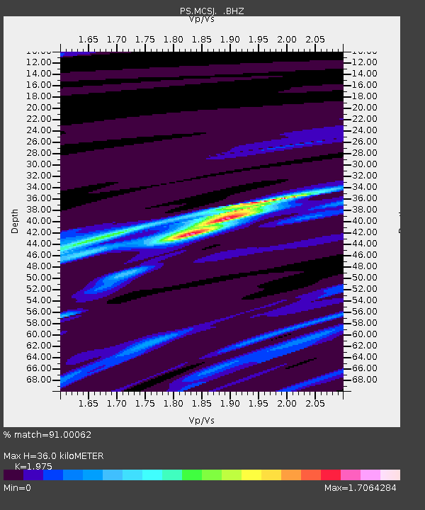
| Estimated Moho Depth: |
36.0 km |
| Estimated Crust Vp/Vs: |
1.98 |
| Assumed Crust Vp: |
4.24 km/s |
| Estimated Crust Vs: |
2.147 km/s |
| Estimated Crust Poisson's Ratio: |
0.33 |
|
| Radial Match: |
91.00062 % |
| Radial Bump: |
287 |
| Transverse Match: |
80.89004 % |
| Transverse Bump: |
400 |
| SOD ConfigId: |
4480 |
| Insert Time: |
2010-02-27 02:57:46.753 +0000 |
| GWidth: |
2.5 |
| Max Bumps: |
400 |
| Tol: |
0.001 |
|
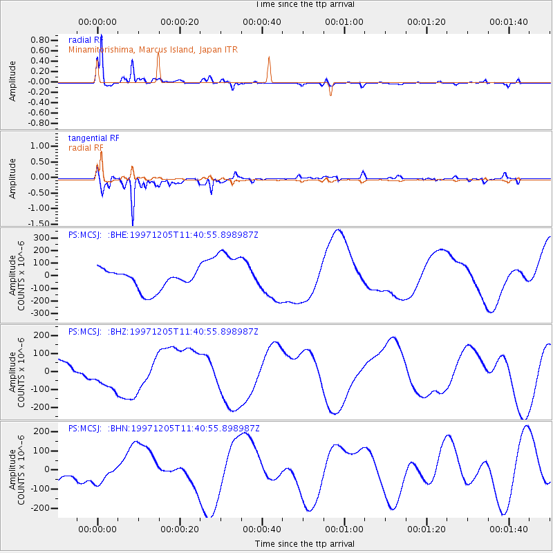
Signal To Noise
| Channel | StoN | STA | LTA |
| PS:MCSJ: :BHZ:19971205T11:40:55.898987Z | 1.973774 | 9.910174E-5 | 5.0209263E-5 |
| PS:MCSJ: :BHN:19971205T11:40:55.898987Z | 1.207576 | 4.8253074E-5 | 3.995862E-5 |
| PS:MCSJ: :BHE:19971205T11:40:55.898987Z | 2.6634321 | 2.0371203E-4 | 7.648478E-5 |
| Arrivals |
| Ps | 8.5 SECOND |
| PpPs | 25 SECOND |
| PsPs/PpSs | 33 SECOND |


