You are here: Home > Network List > PS - Pacific21 Stations List
> Station MCSJ Minamitorishima, Marcus Island, Japan > Earthquake Result Viewer
MCSJ Minamitorishima, Marcus Island, Japan - Earthquake Result Viewer
| Earthquake location: |
New Britain Region, P.N.G. |
| Earthquake latitude/longitude: |
-5.7/151.7 |
| Earthquake time(UTC): |
2005/09/30 (273) 23:15:19 GMT |
| Earthquake Depth: |
25 km |
| Earthquake Magnitude: |
5.5 MB, 5.7 MS, 5.9 MW, 5.9 MW |
| Earthquake Catalog/Contributor: |
WHDF/NEIC |
|
| Network: |
PS Pacific21 |
| Station: |
MCSJ Minamitorishima, Marcus Island, Japan |
| Lat/Lon: |
24.29 N/153.98 E |
| Elevation: |
10 m |
|
| Distance: |
29.9 deg |
| Az: |
4.209 deg |
| Baz: |
184.591 deg |
| Ray Param: |
0.07946433 |
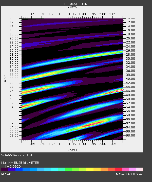
| Estimated Moho Depth: |
45.25 km |
| Estimated Crust Vp/Vs: |
2.09 |
| Assumed Crust Vp: |
4.24 km/s |
| Estimated Crust Vs: |
2.026 km/s |
| Estimated Crust Poisson's Ratio: |
0.35 |
|
| Radial Match: |
97.20451 % |
| Radial Bump: |
126 |
| Transverse Match: |
82.03212 % |
| Transverse Bump: |
160 |
| SOD ConfigId: |
2564 |
| Insert Time: |
2010-02-27 02:58:03.199 +0000 |
| GWidth: |
2.5 |
| Max Bumps: |
400 |
| Tol: |
0.001 |
|
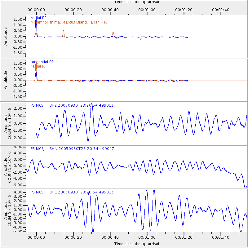
Signal To Noise
| Channel | StoN | STA | LTA |
| PS:MCSJ: :BHN:20050930T23:20:54.49901Z | 1.0523787 | 1.1992846E-6 | 1.1395942E-6 |
| PS:MCSJ: :BHE:20050930T23:20:54.49901Z | 0.709061 | 7.2281733E-7 | 1.0194008E-6 |
| PS:MCSJ: :BHZ:20050930T23:20:54.49901Z | 1.651702 | 1.4827356E-6 | 8.977016E-7 |
| Arrivals |
| Ps | 12 SECOND |
| PpPs | 32 SECOND |
| PsPs/PpSs | 44 SECOND |


