You are here: Home > Network List > PS - Pacific21 Stations List
> Station MCSJ Minamitorishima, Marcus Island, Japan > Earthquake Result Viewer
MCSJ Minamitorishima, Marcus Island, Japan - Earthquake Result Viewer
| Earthquake location: |
Banda Sea |
| Earthquake latitude/longitude: |
-7.7/125.5 |
| Earthquake time(UTC): |
2005/09/12 (255) 21:51:06 GMT |
| Earthquake Depth: |
30 km |
| Earthquake Magnitude: |
5.5 MB, 4.5 MS |
| Earthquake Catalog/Contributor: |
WHDF/NEIC |
|
| Network: |
PS Pacific21 |
| Station: |
MCSJ Minamitorishima, Marcus Island, Japan |
| Lat/Lon: |
24.29 N/153.98 E |
| Elevation: |
10 m |
|
| Distance: |
42.2 deg |
| Az: |
40.371 deg |
| Baz: |
224.716 deg |
| Ray Param: |
0.07326071 |
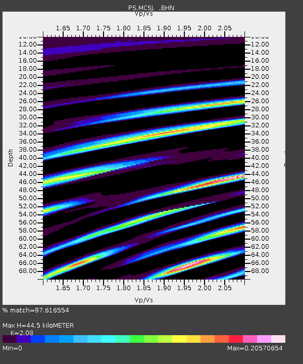
| Estimated Moho Depth: |
44.5 km |
| Estimated Crust Vp/Vs: |
2.08 |
| Assumed Crust Vp: |
4.24 km/s |
| Estimated Crust Vs: |
2.038 km/s |
| Estimated Crust Poisson's Ratio: |
0.35 |
|
| Radial Match: |
97.616554 % |
| Radial Bump: |
124 |
| Transverse Match: |
87.33411 % |
| Transverse Bump: |
198 |
| SOD ConfigId: |
2564 |
| Insert Time: |
2010-02-27 02:58:15.940 +0000 |
| GWidth: |
2.5 |
| Max Bumps: |
400 |
| Tol: |
0.001 |
|
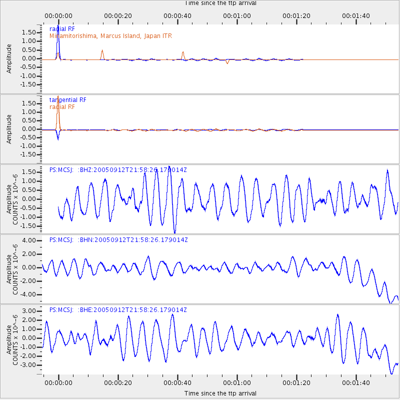
Signal To Noise
| Channel | StoN | STA | LTA |
| PS:MCSJ: :BHN:20050912T21:58:26.179014Z | 1.3410867 | 7.556272E-7 | 5.6344396E-7 |
| PS:MCSJ: :BHE:20050912T21:58:26.179014Z | 0.5803683 | 6.172218E-7 | 1.0635002E-6 |
| PS:MCSJ: :BHZ:20050912T21:58:26.179014Z | 1.7145667 | 1.0833065E-6 | 6.3182523E-7 |
| Arrivals |
| Ps | 12 SECOND |
| PpPs | 32 SECOND |
| PsPs/PpSs | 43 SECOND |


