You are here: Home > Network List > PS - Pacific21 Stations List
> Station MCSJ Minamitorishima, Marcus Island, Japan > Earthquake Result Viewer
MCSJ Minamitorishima, Marcus Island, Japan - Earthquake Result Viewer
| Earthquake location: |
Northern Sumatra, Indonesia |
| Earthquake latitude/longitude: |
4.9/95.0 |
| Earthquake time(UTC): |
2005/09/10 (253) 16:57:47 GMT |
| Earthquake Depth: |
41 km |
| Earthquake Magnitude: |
5.8 MB, 5.5 MS, 5.8 MW, 5.8 MW |
| Earthquake Catalog/Contributor: |
WHDF/NEIC |
|
| Network: |
PS Pacific21 |
| Station: |
MCSJ Minamitorishima, Marcus Island, Japan |
| Lat/Lon: |
24.29 N/153.98 E |
| Elevation: |
10 m |
|
| Distance: |
59.8 deg |
| Az: |
64.79 deg |
| Baz: |
261.11 deg |
| Ray Param: |
0.061895445 |
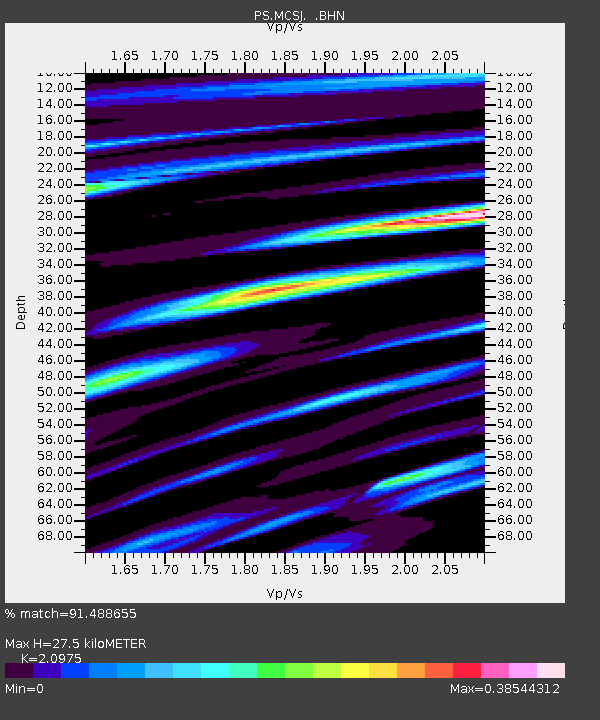
| Estimated Moho Depth: |
27.5 km |
| Estimated Crust Vp/Vs: |
2.10 |
| Assumed Crust Vp: |
4.24 km/s |
| Estimated Crust Vs: |
2.021 km/s |
| Estimated Crust Poisson's Ratio: |
0.35 |
|
| Radial Match: |
91.488655 % |
| Radial Bump: |
149 |
| Transverse Match: |
93.170334 % |
| Transverse Bump: |
128 |
| SOD ConfigId: |
2564 |
| Insert Time: |
2010-02-27 02:59:47.014 +0000 |
| GWidth: |
2.5 |
| Max Bumps: |
400 |
| Tol: |
0.001 |
|
Signal To Noise
| Channel | StoN | STA | LTA |
| PS:MCSJ: :BHN:20050910T17:07:17.319011Z | 1.2952325 | 1.1666432E-6 | 9.0072103E-7 |
| PS:MCSJ: :BHE:20050910T17:07:17.319011Z | 0.5211374 | 1.0238427E-6 | 1.964631E-6 |
| PS:MCSJ: :BHZ:20050910T17:07:17.319011Z | 2.1275427 | 1.6122951E-6 | 7.578203E-7 |
| Arrivals |
| Ps | 7.2 SECOND |
| PpPs | 20 SECOND |
| PsPs/PpSs | 27 SECOND |


