You are here: Home > Network List > PS - Pacific21 Stations List
> Station MCSJ Minamitorishima, Marcus Island, Japan > Earthquake Result Viewer
MCSJ Minamitorishima, Marcus Island, Japan - Earthquake Result Viewer
| Earthquake location: |
Southern Molucca Sea |
| Earthquake latitude/longitude: |
-0.2/125.1 |
| Earthquake time(UTC): |
2005/07/18 (199) 19:37:19 GMT |
| Earthquake Depth: |
19 km |
| Earthquake Magnitude: |
5.8 MB, 5.1 MS, 5.9 MW, 5.8 MW |
| Earthquake Catalog/Contributor: |
WHDF/NEIC |
|
| Network: |
PS Pacific21 |
| Station: |
MCSJ Minamitorishima, Marcus Island, Japan |
| Lat/Lon: |
24.29 N/153.98 E |
| Elevation: |
10 m |
|
| Distance: |
37.0 deg |
| Az: |
46.937 deg |
| Baz: |
233.192 deg |
| Ray Param: |
0.07633509 |
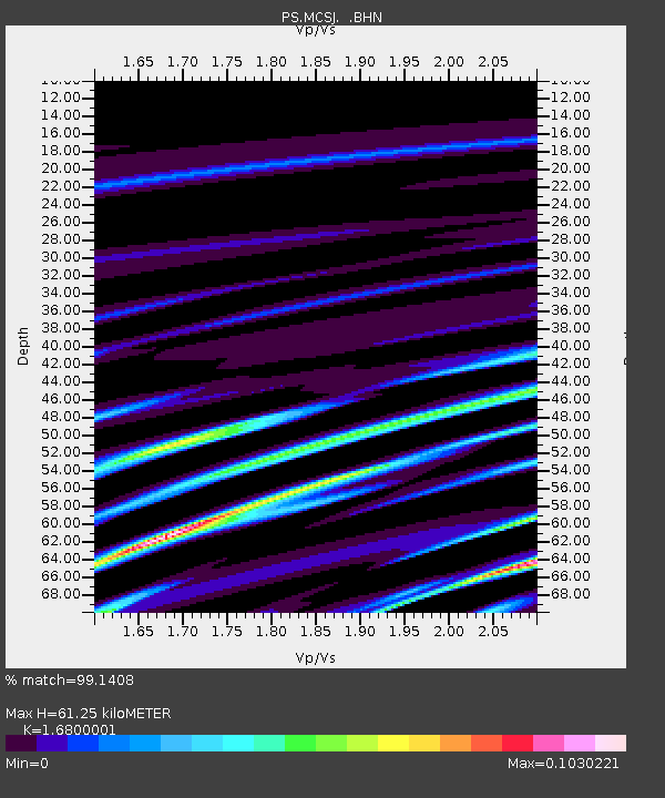
| Estimated Moho Depth: |
61.25 km |
| Estimated Crust Vp/Vs: |
1.68 |
| Assumed Crust Vp: |
4.24 km/s |
| Estimated Crust Vs: |
2.524 km/s |
| Estimated Crust Poisson's Ratio: |
0.23 |
|
| Radial Match: |
99.1408 % |
| Radial Bump: |
69 |
| Transverse Match: |
92.73314 % |
| Transverse Bump: |
106 |
| SOD ConfigId: |
2564 |
| Insert Time: |
2010-02-27 02:59:57.869 +0000 |
| GWidth: |
2.5 |
| Max Bumps: |
400 |
| Tol: |
0.001 |
|
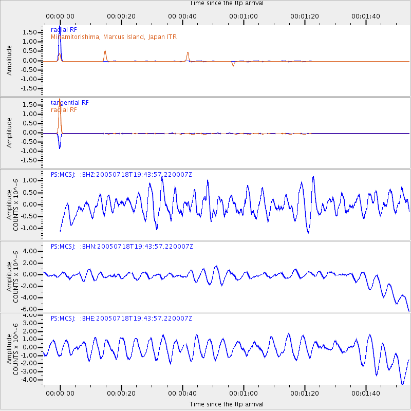
Signal To Noise
| Channel | StoN | STA | LTA |
| PS:MCSJ: :BHN:20050718T19:43:57.220007Z | 0.8602833 | 3.728998E-7 | 4.3346162E-7 |
| PS:MCSJ: :BHE:20050718T19:43:57.220007Z | 1.3452153 | 6.5572993E-7 | 4.874535E-7 |
| PS:MCSJ: :BHZ:20050718T19:43:57.220007Z | 2.2058945 | 7.193688E-7 | 3.261121E-7 |
| Arrivals |
| Ps | 10 SECOND |
| PpPs | 37 SECOND |
| PsPs/PpSs | 48 SECOND |


