You are here: Home > Network List > PS - Pacific21 Stations List
> Station MCSJ Minamitorishima, Marcus Island, Japan > Earthquake Result Viewer
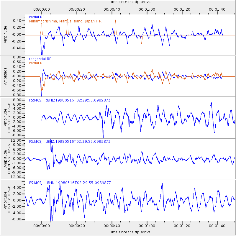
MCSJ Minamitorishima, Marcus Island, Japan - Earthquake Result Viewer
*The percent match for this event was below the threshold and hence no stack was calculated.
| Earthquake location: |
South Of Fiji Islands |
| Earthquake latitude/longitude: |
-22.2/-179.5 |
| Earthquake time(UTC): |
1998/05/16 (136) 02:22:03 GMT |
| Earthquake Depth: |
586 km |
| Earthquake Magnitude: |
6.1 MB, 6.8 UNKNOWN |
| Earthquake Catalog/Contributor: |
WHDF/NEIC |
|
| Network: |
PS Pacific21 |
| Station: |
MCSJ Minamitorishima, Marcus Island, Japan |
| Lat/Lon: |
24.29 N/153.98 E |
| Elevation: |
10 m |
|
| Distance: |
52.9 deg |
| Az: |
329.313 deg |
| Baz: |
148.787 deg |
| Ray Param: |
$rayparam |
*The percent match for this event was below the threshold and hence was not used in the summary stack. |
|
| Radial Match: |
65.40898 % |
| Radial Bump: |
399 |
| Transverse Match: |
79.17287 % |
| Transverse Bump: |
342 |
| SOD ConfigId: |
4480 |
| Insert Time: |
2010-02-27 02:59:59.143 +0000 |
| GWidth: |
2.5 |
| Max Bumps: |
400 |
| Tol: |
0.001 |
|
Signal To Noise
| Channel | StoN | STA | LTA |
| PS:MCSJ: :BHZ:19980516T02:29:55.098987Z | 6.9114995 | 3.0430574E-6 | 4.4028903E-7 |
| PS:MCSJ: :BHN:19980516T02:29:55.098987Z | 2.9792922 | 2.1934045E-6 | 7.3621663E-7 |
| PS:MCSJ: :BHE:19980516T02:29:55.098987Z | 1.0021746 | 1.21467E-6 | 1.2120342E-6 |
| Arrivals |
| Ps | |
| PpPs | |
| PsPs/PpSs | |


