You are here: Home > Network List > PS - Pacific21 Stations List
> Station MCSJ Minamitorishima, Marcus Island, Japan > Earthquake Result Viewer
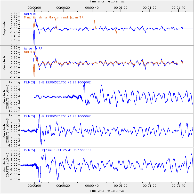
MCSJ Minamitorishima, Marcus Island, Japan - Earthquake Result Viewer
*The percent match for this event was below the threshold and hence no stack was calculated.
| Earthquake location: |
Minahassa Peninsula, Sulawesi |
| Earthquake latitude/longitude: |
0.2/119.6 |
| Earthquake time(UTC): |
1998/05/21 (141) 05:34:25 GMT |
| Earthquake Depth: |
33 km |
| Earthquake Magnitude: |
6.2 MB, 6.3 MS, 6.6 UNKNOWN, 6.6 MW |
| Earthquake Catalog/Contributor: |
WHDF/NEIC |
|
| Network: |
PS Pacific21 |
| Station: |
MCSJ Minamitorishima, Marcus Island, Japan |
| Lat/Lon: |
24.29 N/153.98 E |
| Elevation: |
10 m |
|
| Distance: |
41.0 deg |
| Az: |
51.75 deg |
| Baz: |
239.385 deg |
| Ray Param: |
$rayparam |
*The percent match for this event was below the threshold and hence was not used in the summary stack. |
|
| Radial Match: |
91.20429 % |
| Radial Bump: |
267 |
| Transverse Match: |
84.16422 % |
| Transverse Bump: |
321 |
| SOD ConfigId: |
4480 |
| Insert Time: |
2010-02-27 03:00:08.877 +0000 |
| GWidth: |
2.5 |
| Max Bumps: |
400 |
| Tol: |
0.001 |
|
Signal To Noise
| Channel | StoN | STA | LTA |
| PS:MCSJ: :BHZ:19980521T05:41:35.100006Z | 16.459661 | 5.4107522E-6 | 3.2872802E-7 |
| PS:MCSJ: :BHN:19980521T05:41:35.100006Z | 13.767924 | 4.187943E-6 | 3.0418113E-7 |
| PS:MCSJ: :BHE:19980521T05:41:35.100006Z | 9.1511965 | 4.750581E-6 | 5.1912133E-7 |
| Arrivals |
| Ps | |
| PpPs | |
| PsPs/PpSs | |


