You are here: Home > Network List > PS - Pacific21 Stations List
> Station MCSJ Minamitorishima, Marcus Island, Japan > Earthquake Result Viewer
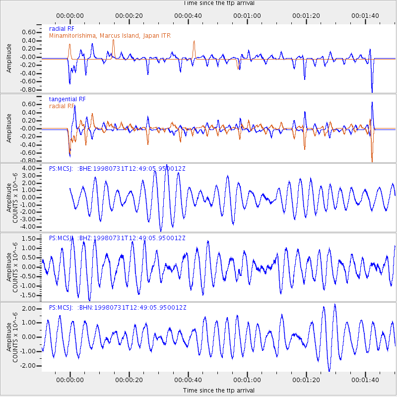
MCSJ Minamitorishima, Marcus Island, Japan - Earthquake Result Viewer
*The percent match for this event was below the threshold and hence no stack was calculated.
| Earthquake location: |
Southeast Of Loyalty Islands |
| Earthquake latitude/longitude: |
-21.6/169.8 |
| Earthquake time(UTC): |
1998/07/31 (212) 12:40:59 GMT |
| Earthquake Depth: |
33 km |
| Earthquake Magnitude: |
5.9 MS, 5.4 MB, 6.1 UNKNOWN, 6.0 MW |
| Earthquake Catalog/Contributor: |
WHDF/NEIC |
|
| Network: |
PS Pacific21 |
| Station: |
MCSJ Minamitorishima, Marcus Island, Japan |
| Lat/Lon: |
24.29 N/153.98 E |
| Elevation: |
10 m |
|
| Distance: |
48.2 deg |
| Az: |
340.466 deg |
| Baz: |
160.064 deg |
| Ray Param: |
$rayparam |
*The percent match for this event was below the threshold and hence was not used in the summary stack. |
|
| Radial Match: |
33.57642 % |
| Radial Bump: |
288 |
| Transverse Match: |
47.912937 % |
| Transverse Bump: |
287 |
| SOD ConfigId: |
4480 |
| Insert Time: |
2010-02-27 03:03:59.294 +0000 |
| GWidth: |
2.5 |
| Max Bumps: |
400 |
| Tol: |
0.001 |
|
Signal To Noise
| Channel | StoN | STA | LTA |
| PS:MCSJ: :BHZ:19980731T12:49:05.950012Z | 1.8693814 | 1.0744928E-6 | 5.7478525E-7 |
| PS:MCSJ: :BHN:19980731T12:49:05.950012Z | 0.7949312 | 8.689502E-7 | 1.0931137E-6 |
| PS:MCSJ: :BHE:19980731T12:49:05.950012Z | 2.259484 | 3.0567337E-6 | 1.3528459E-6 |
| Arrivals |
| Ps | |
| PpPs | |
| PsPs/PpSs | |


