You are here: Home > Network List > PS - Pacific21 Stations List
> Station MCSJ Minamitorishima, Marcus Island, Japan > Earthquake Result Viewer
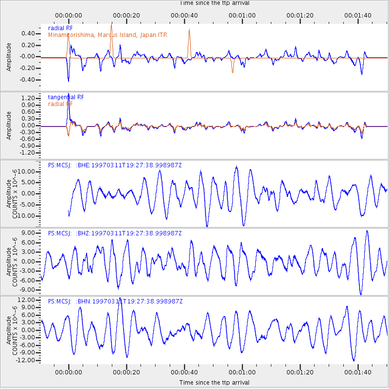
MCSJ Minamitorishima, Marcus Island, Japan - Earthquake Result Viewer
*The percent match for this event was below the threshold and hence no stack was calculated.
| Earthquake location: |
Philippine Islands Region |
| Earthquake latitude/longitude: |
7.7/127.6 |
| Earthquake time(UTC): |
1997/03/11 (070) 19:22:00 GMT |
| Earthquake Depth: |
10 km |
| Earthquake Magnitude: |
6.3 MB, 6.7 MS, 6.9 UNKNOWN, 6.8 MW |
| Earthquake Catalog/Contributor: |
WHDF/NEIC |
|
| Network: |
PS Pacific21 |
| Station: |
MCSJ Minamitorishima, Marcus Island, Japan |
| Lat/Lon: |
24.29 N/153.98 E |
| Elevation: |
10 m |
|
| Distance: |
30.1 deg |
| Az: |
53.827 deg |
| Baz: |
241.245 deg |
| Ray Param: |
$rayparam |
*The percent match for this event was below the threshold and hence was not used in the summary stack. |
|
| Radial Match: |
55.516327 % |
| Radial Bump: |
387 |
| Transverse Match: |
57.223404 % |
| Transverse Bump: |
400 |
| SOD ConfigId: |
4480 |
| Insert Time: |
2010-02-27 03:04:16.175 +0000 |
| GWidth: |
2.5 |
| Max Bumps: |
400 |
| Tol: |
0.001 |
|
Signal To Noise
| Channel | StoN | STA | LTA |
| PS:MCSJ: :BHZ:19970311T19:27:38.998987Z | 1.3428243 | 3.2360956E-6 | 2.4099172E-6 |
| PS:MCSJ: :BHN:19970311T19:27:38.998987Z | 2.708988 | 6.363163E-6 | 2.3489079E-6 |
| PS:MCSJ: :BHE:19970311T19:27:38.998987Z | 2.1944962 | 7.1588374E-6 | 3.262178E-6 |
| Arrivals |
| Ps | |
| PpPs | |
| PsPs/PpSs | |


